North Burntbush River facts for kids
Quick facts for kids North Burntbush |
|
|---|---|

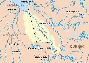
Harricana River basin in yellow
|
|
| Country | Canada |
| Province | Ontario |
| District | Cochrane |
| Physical characteristics | |
| Main source | Cochrane District, Ontario 305 m (1,001 ft) 49°40′35″N 80°15′10″W / 49.67639°N 80.25278°W |
| River mouth | Burntbush River Cochrane District, Ontario 297 m (974 ft) 49°39′04″N 80°08′48″W / 49.65111°N 80.14667°W |
| Length | 17.6 km (10.9 mi) |
The North Burntbush River is a smaller river that flows into the Burntbush River. It is located in the Cochrane District in Northeastern Ontario, Canada.
The main activity in this area is forestry, which means cutting down trees for wood. Tourism and outdoor fun are also important here.
The river usually freezes over in early November. It stays frozen until mid-May. It's generally safe to be on the ice from mid-November to the end of April.
Contents
Where the River Flows
The North Burntbush River is surrounded by other important water bodies. Here are some of them:
- To the north: Kesagami River, North Burntbush Lake, and Lake George.
- To the east: Burntbush River, Detour River, and Case River.
- To the south: Mikwam River and Burntbush River.
- To the west: Burntbush River and Seguin River.
River's Starting Point
The North Burntbush River begins at Lake George. This lake is about 2.1 kilometres (1.3 mi) long. It sits at an elevation of 305 metres (1,001 ft) above sea level.
The river's starting point is about 1.2 kilometres (0.75 mi) east of Highway 652 in Ontario. It's also 8.2 kilometres (5.1 mi) west of where the North Burntbush River joins the main Burntbush River.
How the River Travels
From Lake George, the North Burntbush River flows for about 17.6 kilometres (10.9 mi). It moves in a few different sections:
- First, it flows 9.8 kilometres (6.1 mi) towards the southeast, then northeast. It passes through some wet, marshy areas. This part ends at the south shore of North Burntbush Lake.
- Next, it travels 1.2 kilometres (0.75 mi) north. It crosses the southeastern part of North Burntbush Lake.
- Finally, it flows 6.6 kilometres (4.1 mi) southeast until it reaches its end.
Where the River Ends
The North Burntbush River joins the main Burntbush River at a specific spot. This meeting point is:
- About 45.5 kilometres (28.3 mi) west of the border between Ontario and Quebec.
- About 56.5 kilometres (35.1 mi) south of a bay in Kesagami Lake.
- About 48.3 kilometres (30.0 mi) northwest of where the Burntbush River meets the Turgeon River.
- About 9.2 kilometres (5.7 mi) east of Ontario's Highway 652.
What's in a Name?
The names "Upper Burntbush Lake," "North Burntbush Lake," "Burntbush Lake," and "Burntbush River" all come from the same origin. They are related to each other.
 | May Edward Chinn |
 | Rebecca Cole |
 | Alexa Canady |
 | Dorothy Lavinia Brown |

