Case River facts for kids
Quick facts for kids Case River |
|
|---|---|

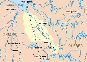
Harricana River basin in yellow
|
|
| Country | Canada |
| Province | Ontario |
| District | Cochrane |
| Physical characteristics | |
| Main source | Cochrane District, Ontario 348 m (1,142 ft) 49°01′00″N 79°55′37″W / 49.01667°N 79.92694°W |
| River mouth | Kabika River Cochrane District, Ontario 259 m (850 ft) 49°17′26″N 79°52′56″W / 49.29056°N 79.88222°W |
| Length | 51.6 km (32.1 mi) |
The Case River is a river in Canada, located in Northeastern Ontario's Cochrane District. It flows into the Kabika River. The river passes through areas like Steele, Case, and Kenning townships.
People in this area mainly work in forestry, which means cutting down trees. Tourism, like visiting for fun, is also important. A road called Ontario Highway 652 runs along the west side of the river.
The river usually freezes over from early November until mid-May. It's generally safe to walk or travel on the ice from mid-November to the end of April.
Contents
Where is the Case River?
The Case River is in Ontario, Canada. It is surrounded by other rivers and lakes. Knowing these helps us understand where the Case River fits in the bigger water system.
Rivers and Lakes Nearby
- To the north: Kabika River and Burntbush River.
- To the east: Kabika River, East Kabika River, Patten River, and Turgeon River.
- To the south: Mace Creek, Lake Abitibi, and Little Kaminisinakwa River.
- To the west: Little Joe Creek, Kenning River, and Séguin River.
Where the River Starts
The Case River starts at a place called Wheat Lake. This lake is in the northern part of Steele Township. Wheat Lake is about 348 meters (1,142 feet) above sea level.
Near the lake, there's a mountain that is 432 meters (1,417 feet) tall. It even has a guard tower! The start of the Case River is about 6.6 kilometers (4.1 miles) north of Lake Abitibi.
How the River Flows
The Case River flows for about 51.6 kilometers (32.1 miles). Here's how it travels:
- It flows northwest for 6.8 kilometers (4.2 miles) through Steele Township.
- Then, it goes north for 23.1 kilometers (14.4 miles) in Case Township.
- Next, it turns northwest for 2.6 kilometers (1.6 miles) in Kenning Township. Here, another river called the Kenning River joins it.
- Finally, it flows north and then northeast for 19.4 kilometers (12.1 miles). It winds through Hurtubise Township before reaching its end.
Where the River Ends
The Case River joins the Kabika River in Hurtubise Township. This meeting point is:
- 16.3 kilometers (10.1 miles) west of the Ontario-Quebec border.
- 16.3 kilometers (10.1 miles) southwest of where the Kabika River meets the Burntbush River.
- 31.3 kilometers (19.4 miles) southwest of where the Burntbush River meets the Turgeon River.
- About 7.5 kilometers (4.7 miles) northwest of a bay in Kesagami Lake.
- 43.4 kilometers (27.0 miles) east of Ontario Highway 652.
What's in a Name?
The name "Case" comes from an English family name.
 | Madam C. J. Walker |
 | Janet Emerson Bashen |
 | Annie Turnbo Malone |
 | Maggie L. Walker |

