Kabika River facts for kids
Quick facts for kids Kabika |
|
|---|---|

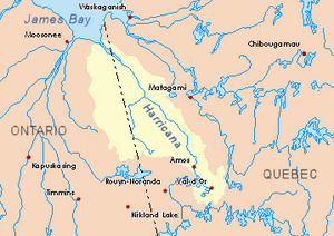
Harricana River basin in yellow
|
|
| Country | Canada |
| District | Cochrane |
| Physical characteristics | |
| Main source | Cochrane District, Ontario 298 m (978 ft) 49°01′22″N 79°52′10″W / 49.02278°N 79.86944°W |
| River mouth | Burntbush River Cochrane District, Ontario 259 m (850 ft) 49°25′19″N 79°47′25″W / 49.42194°N 79.79028°W |
| Length | 69.3 km (43.1 mi) |
The Kabika River is a river in Northeastern Ontario, Canada. It flows into the Burntbush River. This area is part of the Cochrane District.
The main activity in this region is forestry, which means cutting down trees for wood. Recreational tourism, like visiting for fun, is also popular. You can reach the west side of the river's area using Ontario Road 652.
The Kabika River usually freezes over in early November. It stays frozen until mid-May. However, it's generally safe to walk or travel on the ice from mid-November to the end of April.
Contents
Where Does the Kabika River Flow?
The Kabika River flows through a specific area. Other rivers and places nearby include:
- North: The Mikwam River and the Burntbush River.
- East: The East Kabika River, Patten River, and Turgeon River.
- South: Lake Abitibi and the La Reine River (Lake Abitibi).
- West: The Case River, Kenning River, Seguin River, and Payntouk Creek.
Where the Kabika River Starts
The Kabika River begins in a small forest lake. This lake is about 298 metres (978 ft) (978 feet) above sea level. It is located in the northern part of Scapa Township. This starting point is northeast of a mountain that is 409 metres (1,342 ft) (1,342 feet) tall.
The River's Journey
From its starting lake, the Kabika River flows for about 69.3 kilometres (43.1 mi) (43.1 miles). It winds its way through several townships:
- First, it flows for 3.5 kilometres (2.2 mi) (2.2 miles) into Lake Kabika.
- Then, it travels about 18.6 kilometres (11.6 mi) (11.6 miles) north, winding through Abbotsford and Case townships.
- Next, it flows for 20.5 kilometres (12.7 mi) (12.7 miles) north through Singer and Kenning townships. Here, it meets the Case River.
- It continues north for 4.7 kilometres (2.9 mi) (2.9 miles) through Kenning and Singer townships.
- After that, it flows for 15.6 kilometres (9.7 mi) (9.7 miles) north and northeast through Tomlinson and Hurtubise townships. It joins the East Kabika River here.
- Finally, it flows for 6.4 kilometres (4.0 mi) (4.0 miles) northwest, making a few turns before reaching its end.
Where the Kabika River Ends
The Kabika River ends when it joins the Burntbush River. This meeting point, called a confluence, is in Hurtubise Township. It's about 19.9 kilometres (12.4 mi) (12.4 miles) west of the border between Ontario and Quebec. It's also about 37.9 kilometres (23.5 mi) (23.5 miles) east of Ontario Highway 652.
What's in a Name?
The word "toponymy" means the study of place names. The name "Kabika River" is related to another river in the same area of the Cochrane District, the East Kakiba River. They likely share a similar origin for their names.
 | Laphonza Butler |
 | Daisy Bates |
 | Elizabeth Piper Ensley |

