Patten River facts for kids
Quick facts for kids Patten |
|
|---|---|

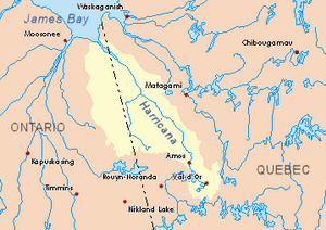
Harricana River basin in yellow
|
|
| Country | Canada |
| Provinces | |
| Physical characteristics | |
| Main source | Cochrane District, Ontario 49°06′52″N 79°28′37″W / 49.11444°N 79.47694°W |
| River mouth | Turgeon River Cochrane District, Ontario 259 m (850 ft) 49°27′31″N 79°31′18″W / 49.45861°N 79.52167°W |
| Length | 51.0 km (31.7 mi) |
| Basin features | |
| Tributaries |
|
The Patten River is a river in Canada. It flows into the Turgeon River, which then joins the Harricana River. The Harricana River eventually empties into James Bay. The Patten River travels through parts of northwestern Quebec and northeastern Ontario, specifically the Cochrane District.
Where the Patten River Flows
The Patten River starts in the western part of the Eeyou Istchee Baie-James area in Quebec. It then flows mostly northwest.
River Neighbors
Rivers often have "neighbors" called hydrographic slopes. These are the areas of land that drain water into a particular river. For the Patten River, its neighbors are:
- North: Burntbush River (in Ontario)
- East: Turgeon River (in Ontario and Quebec) and Boivin River (in Quebec)
- South: Chaboillez River (in Ontario) and La Reine River (in Ontario)
- West: Kabika River (in Ontario), Kabika River East (in Ontario), and Case River (in Ontario)
The River's Journey
The main source of the Patten River is Bill Lake. This lake is about 800 meters long and sits at an elevation of 298 meters. It's special because it's right on the border between Ontario and Quebec!
Before reaching Bill Lake, the Patten River flows for about 3.8 kilometers through marshy areas in Quebec. Along this part, it collects water from several smaller streams. One important stream comes from the south, near the border, and feeds into the Patten River about 1.8 kilometers from its mouth. This stream also gets water from Lake Poison.
After Bill Lake, the Patten River continues its journey:
- It flows west for 1.7 kilometers into Lake Joe in Ontario.
- Then, it travels about 10 kilometers northwest, curving north and picking up water from many surrounding creeks.
- Next, it goes about 7 kilometers further northwest.
- For the longest stretch, about 26.8 kilometers, it flows north, often running parallel to the Ontario-Quebec border. In some places, it goes as far as 11.25 kilometers into Ontario.
- Finally, it flows about 22.5 kilometers north, making a curve to the west before reaching its mouth.
The Patten River ends in a swampy area in Ontario. It's located about 2 kilometers west of the Ontario-Quebec border.
What's in a Name?
The name "Patten" comes from an English family name.
 | DeHart Hubbard |
 | Wilma Rudolph |
 | Jesse Owens |
 | Jackie Joyner-Kersee |
 | Major Taylor |

