Boivin River facts for kids
Quick facts for kids Boivin |
|
|---|---|

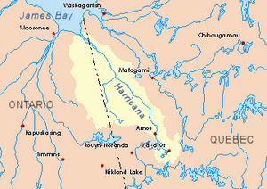
Harricana River basin in yellow
|
|
| Country | Canada |
| Province | Ontario |
| Region | Nord-du-Québec |
| Physical characteristics | |
| Main source | Eeyou Istchee Baie-James (municipality), Quebec 49°16′11″N 79°20′04″W / 49.26972°N 79.33444°W |
| River mouth | Turgeon River Eeyou Istchee Baie-James (municipality), Nord-du-Québec, Quebec 276 m (906 ft) 49°27′31″N 79°31′18″W / 49.45861°N 79.52167°W |
The Boivin River is a river in Quebec, Canada. It flows into the Turgeon River. The Turgeon River is a larger river that eventually joins the Harricana River. All these rivers flow towards James Bay in Ontario.
The Boivin River is located in the Nord-du-Québec region, within the large municipality of Eeyou Istchee Baie-James. It's an important part of the local water system.
Contents
Where the Boivin River Flows
The Boivin River is surrounded by other rivers and streams. These are called its "hydrographic slopes." Think of them as the areas that drain water into the Boivin River.
- To the north, you'll find the Turgeon River.
- To the east, there's Hal Creek and more of the Turgeon River.
- To the south, you'll see the South River and the La Sarre River.
- To the west, the Patten River in Ontario runs nearby.
The River's Journey
The Boivin River starts in the southeastern part of a place called Perron township. It then flows mostly north through this township. It also crosses a part of Boivin township further down its path.
As it flows north, the river stays about 15 to 16 kilometers (about 9 to 10 miles) away from the border between Quebec and Ontario.
How the River Starts
The Boivin River actually begins with three smaller streams that join together. These streams meet southwest of a village called Val-Paradis, Quebec.
- Tremblay Watercourse: This stream is about 7.5 kilometers (4.7 miles) long. It comes from the southeast and drains water from marshy areas.
- Lavoie Stream: This stream has two smaller branches. One branch comes from Lake Imbeau and Oloron Lake. The other branch comes from Domena Lake and Pajegasque Lake. Pajegasque Lake is a popular spot with a diameter of about 1.1 kilometers (0.7 miles). The Lavoie stream starts in a swampy area and flows north for many kilometers before joining the other branches.
- Third Branch: This stream comes from the west. It also has two smaller parts that join up before this branch flows east to meet the Boivin River.
After these three branches combine, the Boivin River flows north for about 1.8 kilometers (1.1 miles). It then passes under Road 393, which is close to Val-Paradis, Quebec. From there, the river continues through a forested area for about 12.5 kilometers (7.8 miles). Finally, it empties into the Turgeon River on its west bank.
The Boivin River is the main Quebec stream that feeds into the Turgeon River. The Turgeon River then flows into the Harricana River, which eventually reaches James Bay.
Why is it Called Boivin River?
The name "Boivin River" is connected to the "Boivin township." A "toponym" is a place name, and these two names are linked.
The Boivin township is located about 45 kilometers (28 miles) north-northwest of La Sarre, Quebec. It shares its western border with the province of Ontario.
Honoring a Canadian Politician
The name "Boivin" honors a man named Georges-Henri Boivin (1882-1926). He was a Member of Parliament for Shefford County. A Member of Parliament is a person elected to represent a specific area in the Canadian Parliament. This is where laws are made for the country.
Georges-Henri Boivin served in Parliament from 1911 to 1926. In 1925, he also held the important job of Minister of Customs and Excise. This role involved managing taxes on goods coming into and out of the country.
The Boivin township was officially named in 1940. The name "Boivin River" was made official on December 5, 1968. This was done by the Commission de toponymie du Quebec, which is the group in charge of naming places in Quebec.
 | Chris Smalls |
 | Fred Hampton |
 | Ralph Abernathy |

