Turcotte River facts for kids
Quick facts for kids Turcotte |
|
|---|---|

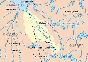
Harricana River basin in yellow
|
|
| Country | Canada |
| Provinces | |
| Physical characteristics | |
| Main source | Upper Turcotte Lake Cochrane District, Ontario 311 m (1,020 ft) 49°41′55″N 79°48′01″W / 49.69861°N 79.80028°W |
| River mouth | Turgeon River Eeyou Istchee Baie-James (municipalité)|Eeyou Istchee Baie-James, Nord-du-Québec, Quebec 259 m (850 ft) 49°30′54″N 79°30′09″W / 49.51500°N 79.50250°W |
| Length | 51.1 km (31.8 mi) |
The Turcotte River is a river in Canada. It flows into the Turgeon River. A "tributary" is a smaller river or stream that flows into a larger river.
The Turcotte River starts in the Cochrane District of Ontario. Then, it flows into the Eeyou Istchee Baie-James area in Quebec.
For much of the year, the river's surface is frozen. This usually happens from early November until mid-May. However, it's generally safe to walk or travel on the ice from mid-November to the end of April.
Contents
Where Does the Turcotte River Flow?
The Turcotte River is surrounded by other rivers and land areas. These are called its "hydrographic slopes." Think of them as the areas that drain water into the Turcotte River or are nearby.
- To the north, you'll find the Little Turcotte River and the Detour River.
- To the east, there's the Turgeon River and the Garneau River.
- To the south, you can see the Burntbush River and the Kabika River.
- To the west, there are the Chabie River and the Burntbush River.
How Long is the Turcotte River?
The Turcotte River begins at Upper Turcotte Lake. This lake is in the eastern part of the Cochrane District in Ontario. The lake is about 1.1 kilometers (0.7 miles) long. Its surface is about 311 meters (1,020 feet) above sea level.
The river flows for about 51.1 kilometers (31.8 miles) from this lake. It winds through different areas before joining the Turgeon River.
Where Does the Turcotte River End?
The Turcotte River flows into the northwest side of the Turgeon River. This meeting point is called a "confluence." It's located near the border between Quebec and Ontario.
This confluence is about 87.1 kilometers (54.1 miles) west of the village of Joutel, Quebec. It's also about 82.3 kilometers (51.1 miles) north of the town of La Sarre, Quebec.
What Does "Turcotte" Mean?
The name "Turcotte" comes from a family name that is originally French.
The name "Rivière Turcotte" became official on December 5, 1968. This was when the Commission de toponymie du Québec (Quebec Toponymy Commission) was created. This commission is in charge of naming places in Quebec.
 | Misty Copeland |
 | Raven Wilkinson |
 | Debra Austin |
 | Aesha Ash |

