La Sarre facts for kids
Quick facts for kids
La Sarre
|
||
|---|---|---|
|
City
|
||

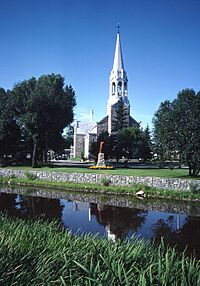
Church of La Sarre
|
||
|
||
| Motto(s):
Oblivisci Nescius
|
||

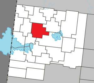
Location within Abitibi-Ouest RCM
|
||
| Country | Canada | |
| Province | Quebec | |
| Region | Abitibi-Témiscamingue | |
| RCM | Abitibi-Ouest | |
| Settled | 1912 | |
| Constituted | 19 April 1980 | |
| Area | ||
| • Total | 153.24 km2 (59.17 sq mi) | |
| • Land | 148.36 km2 (57.28 sq mi) | |
| Population
(2021)
|
||
| • Total | 7,358 | |
| • Density | 49.6/km2 (128/sq mi) | |
| • Pop (2016-21) | ||
| • Dwellings | 3,698 | |
| Time zone | UTC−5 (EST) | |
| • Summer (DST) | UTC−4 (EDT) | |
| Postal code(s) |
J9Z
|
|
| Area code(s) | 819 | |
| Highways | ||
La Sarre is a city in northwestern Quebec, Canada. It is the biggest town and the main center of the Abitibi-Ouest Regional County Municipality. You can find it where two highways, Route 111 and Route 393, meet. The La Sarre River, which flows into Lake Abitibi, runs through the city.
The city of La Sarre also includes a smaller community called Bienvenu. This community is located along Route 111, west of the La Sarre River.
Contents
History of La Sarre
Before European settlers arrived, the Algonquin lived in this area. They called the place Wabakin, which means "there is a mountain of hardwood." They also called the La Sarre River Adikameg Sibi.
The first European settlers arrived in the late 1800s. They settled on the land without official permission. In 1908, their presence was noted during a land survey. The real growth of the settlement began when the National Transcontinental Railway was completed. This railway ran through the Abitibi region.
The first permanent pioneer family arrived in 1912. More settlers followed, attracted by the area's potential for mining, forestry, and farming. This growth led to the formation of the settlement. In 1915, a post office opened. A year later, the La Sarre Township was officially named. It was named after the La Sarre Regiment, a military group famous for its role in the Battle of Carillon and the capture of Fort Oswego in 1756.
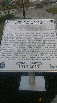
In 1917, the Township Municipality of La Sarre was created. The Parish of Saint-André-de-la-Sarre was also established that same year. The Hudson's Bay Company, a famous trading company, opened a post here in 1932, but it closed in 1941.
In 1937, the village of La Sarre became its own separate municipality. It was officially called the Village Municipality of La Sarre. On August 17, 1949, it became a full town (ville). In April 1980, the town and the township municipality joined together to form the city we know today.
Geography and Climate
La Sarre's Climate
La Sarre has a climate that is mostly humid continental. This means it has warm summers and cold, snowy winters. It is also quite close to a subarctic climate, which means winters can be very harsh.
Each year, La Sarre gets about 2.47 meters (97 inches) of snow. However, sometimes warm air from the southeast can cause temperatures to rise above freezing, even in winter. For example, on February 6, 1988, the temperature reached an amazing 20.5 degrees Celsius (68.9 degrees Fahrenheit). The warmer half of the year is usually pleasant, but it can rain often.
| Climate data for La Sarre | |||||||||||||
|---|---|---|---|---|---|---|---|---|---|---|---|---|---|
| Month | Jan | Feb | Mar | Apr | May | Jun | Jul | Aug | Sep | Oct | Nov | Dec | Year |
| Record high °C (°F) | 7.8 (46.0) |
20.5 (68.9) |
17.0 (62.6) |
29.0 (84.2) |
31.7 (89.1) |
35.0 (95.0) |
37.2 (99.0) |
33.3 (91.9) |
32.2 (90.0) |
26.1 (79.0) |
17.8 (64.0) |
11.1 (52.0) |
37.2 (99.0) |
| Mean daily maximum °C (°F) | −11.7 (10.9) |
−8.9 (16.0) |
−1.8 (28.8) |
7.2 (45.0) |
15.9 (60.6) |
21.5 (70.7) |
23.5 (74.3) |
21.5 (70.7) |
15.7 (60.3) |
8.7 (47.7) |
−0.6 (30.9) |
−8.6 (16.5) |
6.9 (44.4) |
| Daily mean °C (°F) | −18.2 (−0.8) |
−16.2 (2.8) |
−8.8 (16.2) |
0.8 (33.4) |
8.9 (48.0) |
14.3 (57.7) |
16.9 (62.4) |
15.2 (59.4) |
10.3 (50.5) |
4.3 (39.7) |
−4.5 (23.9) |
−14 (7) |
0.7 (33.3) |
| Mean daily minimum °C (°F) | −24.6 (−12.3) |
−23.4 (−10.1) |
−15.7 (3.7) |
−5.7 (21.7) |
1.8 (35.2) |
7.0 (44.6) |
10.3 (50.5) |
8.7 (47.7) |
4.7 (40.5) |
−0.2 (31.6) |
−8.4 (16.9) |
−19.4 (−2.9) |
−5.4 (22.3) |
| Record low °C (°F) | −47 (−53) |
−47 (−53) |
−43.9 (−47.0) |
−31.7 (−25.1) |
−12 (10) |
−6.7 (19.9) |
−2 (28) |
−3.5 (25.7) |
−8.5 (16.7) |
−13 (9) |
−34 (−29) |
−44.5 (−48.1) |
−47 (−53) |
| Average precipitation mm (inches) | 58.6 (2.31) |
37.9 (1.49) |
52.4 (2.06) |
55.9 (2.20) |
78.2 (3.08) |
84.7 (3.33) |
101.0 (3.98) |
99.0 (3.90) |
110.7 (4.36) |
81.5 (3.21) |
67.6 (2.66) |
62.3 (2.45) |
889.8 (35.03) |
| Average rainfall mm (inches) | 5.4 (0.21) |
2.8 (0.11) |
14.4 (0.57) |
40.5 (1.59) |
74.8 (2.94) |
84.7 (3.33) |
101 (4.0) |
99 (3.9) |
110.1 (4.33) |
73.5 (2.89) |
30.1 (1.19) |
7.3 (0.29) |
643.6 (25.35) |
| Average snowfall cm (inches) | 53.3 (21.0) |
35.1 (13.8) |
38 (15) |
15.5 (6.1) |
3.4 (1.3) |
0 (0) |
0 (0) |
0 (0) |
0.6 (0.2) |
8.1 (3.2) |
37.5 (14.8) |
55 (22) |
246.5 (97.4) |
| Average precipitation days (≥ 0.2 mm) | 14.8 | 11.0 | 10.2 | 10.0 | 12.6 | 13.4 | 14.8 | 14.4 | 16.1 | 14.9 | 15.1 | 16.7 | 164 |
| Average rainy days (≥ 0.2 mm) | 0.76 | 0.67 | 3.1 | 7.4 | 12.3 | 13.4 | 14.8 | 14.4 | 15.9 | 13.3 | 5.5 | 1.5 | 103.03 |
| Average snowy days | 14.5 | 10.7 | 8.4 | 4.3 | 0.8 | 0.0 | 0.0 | 0.0 | 0.3 | 2.8 | 11.0 | 15.7 | 68.5 |
| Source: Environment Canada | |||||||||||||
People and Population
In the 2021 Census, La Sarre had a population of 7,358 people. These people lived in 3,493 homes. The city has a total of 3,698 private homes. This population was a small increase of 1.0% from its 2016 population of 7,282.
La Sarre covers a land area of 148.36 square kilometers (57.28 square miles). In 2021, this meant there were about 49.6 people living in each square kilometer. This number is called the population density.
Here is a look at how La Sarre's population has changed over the years:
| Canada census – La Sarre community profile | |||
|---|---|---|---|
| 2016 | 2011 | 2006 | |
| Population: | 7,282 (-5.7% from 2011) | 7,719 (+5.2% from 2006) | 7,336 (-5.1% from 2001) |
| Land area: | 148.50 km2 (57.34 sq mi) | 148.74 km2 (57.43 sq mi) | 148.68 km2 (57.41 sq mi) |
| Population density: | 49.0/km2 (127/sq mi) | 51.9/km2 (134/sq mi) | 49.3/km2 (128/sq mi) |
| Median age: | 48.2 (M: 46.3, F: 50.5) | 46.6 (M: 44.9, F: 47.9) | 43.9 (M: 43.1, F: 44.7) |
| Total private dwellings: | 3,643 | 3,617 | 3,520 |
| Median household income: | $52,119 | $43,315 | $40,772 |
| References: 2016 2011 2006 earlier | |||
| Historical Census Data - La Sarre, Quebec | |||||||||||||||||||||||||||||||||||||||||||||||||||||||
|---|---|---|---|---|---|---|---|---|---|---|---|---|---|---|---|---|---|---|---|---|---|---|---|---|---|---|---|---|---|---|---|---|---|---|---|---|---|---|---|---|---|---|---|---|---|---|---|---|---|---|---|---|---|---|---|
|
|
||||||||||||||||||||||||||||||||||||||||||||||||||||||
| Source: Statistics Canada | |||||||||||||||||||||||||||||||||||||||||||||||||||||||
This table shows the main languages spoken by people in La Sarre:
| Canada Census Mother Tongue - La Sarre, Quebec | ||||||||||||||||||
|---|---|---|---|---|---|---|---|---|---|---|---|---|---|---|---|---|---|---|
| Census | Total |
|
|
|
|
|||||||||||||
| Year | Responses | Count | Trend | Pop % | Count | Trend | Pop % | Count | Trend | Pop % | Count | Trend | Pop % | |||||
|
|
|
7,175 | 98.2% | 35 | 0.5% | 40 | 0.5% | 40 | 0.5% | |||||||||
|
|
|
7,130 | 98.5% | 45 | 0.6% | 20 | 0.3% | 40 | 0.6% | |||||||||
|
|
|
7,510 | 98.0% | 65 | 0.9% | 30 | 0.4% | 60 | 0.8% | |||||||||
|
|
|
7,100 | 98.3% | 50 | 0.7% | 25 | 0.4% | 45 | 0.6% | |||||||||
|
|
|
7,520 | 98.5% | 30 | 0.4% | 30 | 0.4% | 55 | 0.7% | |||||||||
|
|
|
8,175 | n/a | 99.2% | 25 | n/a | 0.3% | 30 | n/a | 0.4% | 10 | n/a | 0.1% | |||||
Economy and Jobs
The most important natural resource in La Sarre is its forest. This forest covers over 4,700 square kilometers (1,800 square miles). It provides wood for the city's main employers, Norbord and Tembec.
Farming is also a big part of the economy. More than 60% of the land in La Sarre is used for growing crops. The mining industry also adds to the local economy. Many small businesses in the service sector help the economy too. The city's airport, La Sarre Airport, helps with travel and business needs.
Famous People from La Sarre
Many notable people have come from La Sarre:
- Aurèle Audet (1920-2015) was a former Member of the National Assembly of Quebec. This is like a provincial politician.
- Marie-Claude Audet is a former cyclist.
- Yvan Bordeleau was also a former Member of the National Assembly of Quebec.
- Gérard Laprise (1925-2000) was a former Member of Parliament. This is like a national politician.
- Bob Mongrain is a former ice hockey player.
- Christine Moore was a former Member of Parliament.
- Doris Piché is a badminton player.
- Sébastien Piché is an ice hockey player.
- Pierre St-Amand is a retired Royal Canadian Air Force Lieutenant-General. This is a very high rank in the military.
- Gilles Ste-Croix is a vice president and co-creator of Cirque du Soleil, a famous entertainment company.
See also
 In Spanish: La Sarre para niños
 | James Van Der Zee |
 | Alma Thomas |
 | Ellis Wilson |
 | Margaret Taylor-Burroughs |


