Little Mikwam River facts for kids
Quick facts for kids Little Mikwam |
|
|---|---|

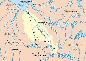
Harricana River basin in yellow
|
|
| Country | Canada |
| Province | Ontario |
| District | Cochrane |
| Physical characteristics | |
| Main source | Cochrane District, Ontario 309 m (1,014 ft) 49°29′41″N 80°06′26″W / 49.49472°N 80.10722°W |
| River mouth | Mikwam River Cochrane District, Ontario 293 m (961 ft) 49°31′01″N 79°09′25″W / 49.51694°N 79.15694°W |
| Length | 11.3 km (7.0 mi) |
The Little Mikwam River is a small river in Canada. It flows into the Mikwam River through Mikwam Lake. You can find it in the Cochrane District of Northeastern Ontario.
People in this area mainly work in forestry, which means they harvest trees. Tourism is also important, with visitors enjoying the outdoors. A road called Ontario Highway 652 helps people get around the western part of the river's area.
The river usually freezes over in early November. It stays frozen until about mid-May. People can safely travel on the ice from mid-November to the end of April.
Contents
River's Journey
The Little Mikwam River starts from a small forest lake. This lake is about 309 meters (1,014 feet) above sea level. From there, the river flows for about 11.3 kilometers (7 miles).
Flowing Through Blakelock Township
The river first flows southeast for about 5.6 kilometers (3.5 miles). Then, it turns northwest towards the south shore of Little Lake Mikwam.
Through Little Lake Mikwam
Next, the river travels westward through Little Lake Mikwam for about 4 kilometers (2.5 miles). This lake is about 4.4 kilometers (2.7 miles) long and sits at an altitude of 298 meters (978 feet).
Reaching the Mikwam River
Finally, the Little Mikwam River flows southwest for about 1.7 kilometers (1.1 miles). It then reaches its end, joining the main Mikwam River.
Where the River Ends
The Little Mikwam River meets the Mikwam River in Blakelock Township. This spot is about 46.2 kilometers (28.7 miles) west of the border between Ontario and Quebec. It is also about 17.6 kilometers (10.9 miles) southwest of where the Mikwam River itself ends.
The river's mouth is about 44.7 kilometers (27.8 miles) west of the Burntbush River's mouth. It is also 71 kilometers (44 miles) south of a bay in Kesagami Lake. The Ontario Highway 652 is about 9.1 kilometers (5.7 miles) southeast of this point.
What's in a Name?
The name "Mikwam" is used for several places in the same area of the Cochrane District. These include the Mikwam River, Little Wikwam River, East Mikwam River, Mikwam Lake, and Mikwam Lake superior. They all share the same origin for their names.
 | John T. Biggers |
 | Thomas Blackshear |
 | Mark Bradford |
 | Beverly Buchanan |

