Lake Turgeon facts for kids
Quick facts for kids Lake Turgeon |
|
|---|---|

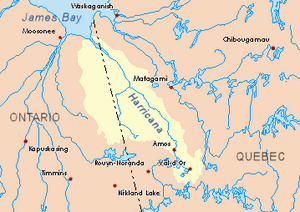
Image of watershed of Harricana River
|
|
| Location | Eeyou Istchee Baie-James (municipality) |
| Coordinates | 49°01′27″N 79°01′15″W / 49.02417°N 79.02083°W |
| Lake type | Natural |
| Primary inflows | Kadiga creek, Deception creek, Ojima River, Lavergne River |
| Primary outflows | Turgeon River |
| Basin countries | Canada |
| Max. length | 9.2 km (9,200 m) |
| Max. width | 4.7 km (4,700 m) |
| Surface elevation | 288 m (945 ft) |
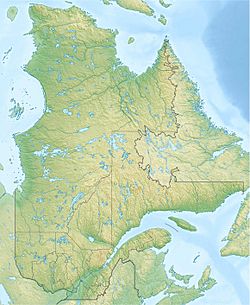
Lake Turgeon is a freshwater lake found in the northwest part of Quebec, Canada. This lake is unique because it crosses the boundaries of two different municipalities:
- Eeyou Istchee Baie-James (municipality), which is in the Nord-du-Québec region.
- Chazel, Quebec, which is in the Abitibi-Témiscamingue region.
A special line that divides these two big regions of Quebec actually runs right through the middle of the southeastern part of Lake Turgeon.
The main activity around the lake is forestry, which means cutting down trees for wood. Another important activity is tourism, where people visit for fun and relaxation.
Roads help people get to the lake. The Conquerors road runs north-south on the west side. Another forest road, "Chemin de la presqu’île," goes east-west. This road leads to a peninsula on the south shore. Many vacation spots have been built on the south shore, especially near where the Lavergne River flows into the lake.
Every year, the lake's surface usually freezes over from mid-November until late April. However, it's generally safe to walk or play on the ice from mid-December to mid-April.
Contents
Exploring Lake Turgeon's Geography
Lake Turgeon is surrounded by many rivers and creeks. These are like its neighbors, either flowing into the lake or carrying water away from it.
Rivers and Creeks Around the Lake
- North side: Kodiga Creek and Hal Creek.
- East side: Trudelle River, Perdrix River (Eeyou Istchee Baie-James), and Davy River.
- South side: Deception Creek, Ojima River, and Lavergne River.
- West side: Turgeon River, Morin Stream, and Leslie Creek.
Bays and Islands of Lake Turgeon
The lake has several interesting bays and islands:
- Nidokwagan Bay is on the south shore, right across from Kakinwanaga Island.
- Kinojeaminikami Bay is in the northwest part of the lake, near where the water flows out.
- Kohokoho Bay is north of the northwestern part of the lake.
- Nigigami Bay is where the Lavergne River enters the lake.
The main islands you can find in Lake Turgeon are Kaicpabikinaga Island, Saban Island, Kawigwasiginaga Island, Cagawapani Island, and Ikodjic Island. There's also Tagwagici Point, a piece of land that sticks out towards the east, forming the southern edge of Kinojeamini Bay.
Where Lake Turgeon's Water Goes
The water from Lake Turgeon flows out through the Turgeon River. The mouth of Lake Turgeon is located:
- About 33.7 kilometres (20.9 mi) east of the border between Quebec and Ontario.
- South of where the Turgeon River begins.
- About 66 kilometres (41 mi) east of the Harricana River.
- About 23.8 kilometres (14.8 mi) northwest of the mouth of Macamic Lake.
The Turgeon River flows for about 216.6 kilometres (134.6 mi), making a big curve to the west. Eventually, it empties into the Harricana River. The Harricana River then flows northwest into Ontario and finally empties into the southern part of James Bay.
The History of Lake Turgeon's Name
In the past, the Native Americans of the Algonquin Nation called this lake "Nigigwadinibi Lake." This name meant "lake with cold crystallized waters." Many of the names for the bays and islands in the lake also come from the Algonquin language.
The name "Lac Turgeon" became official on December 5, 1968. This was decided by the Commission de toponymie du Québec, which is the official group in Quebec that names places.
 | Bayard Rustin |
 | Jeannette Carter |
 | Jeremiah A. Brown |


