Ojima River facts for kids
Quick facts for kids Ojima |
|
|---|---|

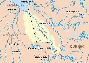
Harricana River basin in yellow
|
|
| Country | Canada |
| Province | Quebec |
| Region | Abitibi-Témiscamingue |
| Physical characteristics | |
| Main source | Swamp pond Rivière-Ojima, Quebec (territoire non organisé), Abitibi-Ouest (MRC), Quebec 314 m (1,030 ft) 48°54′20″N 78°57′24″W / 48.90556°N 78.95667°W |
| River mouth | Lake Turgeon Rivière-Ojima, Quebec (territoire non organise), Abitibi-Témiscamingue, Quebec 288 m (945 ft) 48°59′06″N 79°59′00″W / 48.98500°N 79.98333°W |
| Basin features | |
| Tributaries |
|
The Ojima River is a river in Quebec, Canada. It flows into Lake Turgeon. The river is located in the Abitibi-Ouest area, which is part of the Abitibi-Témiscamingue region.
The main activity around the river is forestry, which means growing and harvesting trees. Recreational tourism, like fishing or boating, is also popular here.
During the colder months, the river usually freezes over. You can often find safe ice for activities from early December to mid-April.
Contents
River's Path and Surroundings
The Ojima River is surrounded by other important water bodies. Here are some of them:
- North: Lake Turgeon and Kodiga Creek.
- East: Deception Creek, Trudelle River, and Perdrix River (Eeyou Istchee Baie-James).
- South: La Sarre River, Macamic Lake, and Chazel Creek.
- West: Brodeur Stream, Lavergne River, Morin Stream, and Leslie Creek.
Where the River Starts
The Ojima River begins in a marshy area. It starts from a pond that is about 1.9 kilometers (1.2 miles) long. This starting point is about 314 meters (1,030 feet) above sea level.
This source is located:
- About 4 kilometers (2.5 miles) southwest of Oditan Hill.
- About 42.2 kilometers (26.2 miles) east of the Ontario-Quebec border.
- About 10.7 kilometers (6.6 miles) southeast of where the Ojima River flows into Lake Turgeon.
- About 22.1 kilometers (13.7 miles) northeast of downtown La Sarre, Quebec.
How the River Flows
From its source, the Ojima River flows for about 19.2 kilometers (11.9 miles). It travels mostly through forested areas.
First, it flows about 9 kilometers (5.6 miles) to the northwest. It crosses a road about 2.5 kilometers (1.6 miles) west of the village of Saint-Eugène-de-Chazel.
Then, it flows about 10.2 kilometers (6.3 miles) to the northeast. It makes a loop to the west and goes through a part of the municipality of Val-Saint-Gilles, Quebec. The river then winds its way until it reaches its mouth.
Where the River Ends
The Ojima River ends by flowing into a marshy area on the south shore of Lake Turgeon.
This mouth of the river is located:
- About 8.2 kilometers (5.1 miles) southeast of the main outlet of Lake Turgeon.
- About 57.2 kilometers (35.5 miles) east of the Ontario-Quebec border.
- About 115 kilometers (71 miles) southeast of the mouth of the Lake Turgeon.
- About 13.7 kilometers (8.5 miles) northeast of the village center of Val-Saint-Gilles.
The Name of the River
The word "toponymy" means the study of place names. The name "Ojima River" was officially recognized on December 5, 1968. This happened when the Commission de toponymie du Québec (Quebec's Place Names Commission) was created.
 | Precious Adams |
 | Lauren Anderson |
 | Janet Collins |

