Corset River facts for kids
Quick facts for kids Corset |
|
|---|---|

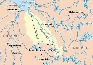
Harricana River basin in yellow
|
|
| Country | Canada |
| Province | Quebec |
| Region | Nord-du-Québec |
| Physical characteristics | |
| Main source | Forested creek Eeyou Istchee Baie-James (municipality), Nord-du-Québec, Quebec 302 m (991 ft) 49°22′38″N 79°15′44″W / 49.37722°N 79.26222°W |
| River mouth | Turgeon River (Harricana River) Eeyou Istchee Baie-James (municipality), Nord-du-Québec, Quebec 259 m (850 ft) 49°31′15″N 79°24′11″W / 49.52083°N 79.40306°W |
| Length | 37.6 km (23.4 mi) |
The Corset River, also known as Rivière du Corset in French, is a river in Quebec, Canada. It flows into the Turgeon River. The Turgeon River is a larger river that the Corset River helps to fill.
This river is located in a part of Quebec called Nord-du-Québec. Specifically, it flows through the area known as Eeyou Istchee Baie-James (municipality). The Corset River passes through three different areas called townships: Laberge, Collet, and Dieppe.
The main activities in this area are forestry, which means harvesting trees. Tourism, like fishing or exploring nature, is also popular. The river usually freezes over in winter, from late November to late April. It's generally safe to be on the ice from early December to mid-April.
Contents
Where the Corset River Flows
The Corset River is part of a larger network of waterways. It has other rivers and creeks nearby that affect its flow.
- North side: The Turgeon River is to the north, flowing through both Ontario and Quebec.
- East side: The Théo River, Wawagosic River, and Memegweci Creek are to the east.
- South side: The Turgeon River and Orfroy Creek are also to the south.
- West side: The Turgeon River and Patten River are to the west.
Starting Point of the River
The Corset River begins as a small stream in a forest. This starting point is about 302 meters (991 feet) above sea level.
- It is about 19 kilometers (12 miles) east of the border between Ontario and Quebec.
- It is also about 19.5 kilometers (12.1 miles) southeast of where the Corset River ends.
- The source is about 69.6 kilometers (43.2 miles) southwest of the village of Joutel, Quebec.
The River's Journey
The Corset River flows for about 37.6 kilometers (23.4 miles) through forested areas.
- For the first 6.7 kilometers (4.2 miles), it flows west through the Laberge township.
- Then, it travels 16.4 kilometers (10.2 miles) northwest through the Collet township, winding its way.
- Finally, it flows 14.5 kilometers (9.0 miles) north through the Dieppe Township, also winding, until it reaches its end.
Where the River Ends
The Corset River empties into the southern bank of the Turgeon River. Right across from its mouth is Corset Island, which is about 3.9 kilometers (2.4 miles) long and 2.1 kilometers (1.3 miles) wide.
- This spot is about 7.0 kilometers (4.3 miles) west of the Ontario-Quebec border.
- It is 64.7 kilometers (40.2 miles) southwest of where the Turgeon River itself ends.
- The mouth of the Corset River is about 81 kilometers (50 miles) west of the village center of Joutel, Quebec.
What's in a Name?
The name "Du Corset" comes from a French family name. This is why the river is called the Corset River.
 | Stephanie Wilson |
 | Charles Bolden |
 | Ronald McNair |
 | Frederick D. Gregory |

