Wawagosic River facts for kids
Quick facts for kids Wawagosic |
|
|---|---|

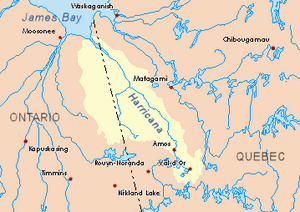
Harricana River basin in yellow
|
|
| Country | Canada |
| Province | Quebec |
| Region | Nord-du-Québec |
| Physical characteristics | |
| Main source | Little marsh Lac-Chicobi, Quebec, Nord-du-Québec, Quebec 288 m (945 ft) 48°59′35″N 78°35′36″W / 48.99306°N 78.59333°W |
| River mouth | Turgeon River Eeyou Istchee Baie-James (municipalité), Quebec 235 m (771 ft) 49°57′51″N 79°05′30″W / 49.96417°N 79.09167°W |
| Basin features | |
| Tributaries |
|
The Wawagosic River is a river in Quebec, Canada. It flows into the Turgeon River. The Turgeon River is a branch of the Harricana River. The Wawagosic River is located in the Nord-du-Québec region, specifically in the area of Eeyou Istchee James Bay.
Contents
Where is the Wawagosic River?
The Wawagosic River starts in a small marsh. This marsh is found near Authier Lake. It is in the unorganized territory of Lac-Chicobi, Quebec. This area is part of the Nord-du-Québec region. The river's starting point is also close to the border of the Abitibi-Témiscamingue region.
The river's source is west of the Octave River (Harricana River). It is also north of Chicobi Lake. This whole area is part of a special place. It is called the Esker-Mistaouac's proposed biodiversity reserve. A biodiversity reserve helps protect nature. It keeps plants and animals safe.
The Wawagosic River gets its water from nearby hills. These include the western side of Saucer Hills. They are about 367 meters (1,204 feet) high. It also gets water from Mount Plamondon. This mountain is about 445 meters (1,460 feet) high.
Rivers and Lakes Nearby
Many other rivers and lakes are close to the Wawagosic River. These are called its hydrographic slopes. They include:
- To the north: The Turgeon River.
- To the east: The Octave River (Harricana River).
- To the south: Chicobi Lake and the Kaomakomiskiwag stream.
- To the west: Lake Turgeon and the Turgeon River.
How the River Flows
The Wawagosic River mainly flows north. Some parts of it turn westward. It passes through many marshy areas. Marshes are wetlands with lots of grasses.
Along its path, the river collects water from several lakes. These lakes include Motherland, Plamondon, and Wawagosic Lake. Other lakes are Cadieux, Carheil, Horney, Morin, Dent, Leblond, and Casgrain.
Wawagosic Lake is about 4.0 kilometers (2.5 miles) long. Water from this lake flows into the Wawagosic River. It does this through the Tangente River. The Tangente River flows for about 6.9 kilometers (4.3 miles) to reach the Wawagosic River.
What's in a Name?
The name "Wawagosic" comes from the Algonquin language. It means "river in zigzag." This name fits the river well. Its banks are made of clay and have no rocks. This zigzag shape was noticed a long time ago.
In 1908, surveyors explored this area. They were looking for ways to develop northwestern Quebec. They were planning for a new railway. At that time, people sometimes called this river "Croche River." "Croche" means "crooked" in French.
The Algonquins of Pikogan gave the name to Wawagosic Lake. This lake is known for its sandy shores. It also has many islands.
The official name "rivière Wawagosic" was made public on December 5, 1968. This was done by the Commission de toponymie du Québec. This commission is in charge of place names in Quebec.
 | Claudette Colvin |
 | Myrlie Evers-Williams |
 | Alberta Odell Jones |

