Martigny River facts for kids
Quick facts for kids Martigny |
|
|---|---|

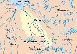
Harricana River basin in yellow
|
|
| Country | Canada |
| Province | Quebec |
| Region | Eeyou Istchee Baie-James (municipality) |
| Physical characteristics | |
| Main source | Lac aux Épices Eeyou Istchee Baie-James (municipality), Nord-du-Québec, Quebec 241 m (791 ft) 50°07′47″N 79°11′42″W / 50.12972°N 79.19500°W |
| River mouth | Turgeon River Eeyou Istchee Baie-James, Quebec 235 m (771 ft) 49°59′20″N 79°00′50″W / 49.98889°N 79.01389°W |
| Length | 30.2 km (18.8 mi) |
| Basin features | |
| Tributaries |
|
The Martigny River is a river located in the Nord-du-Québec region of Quebec, Canada. It flows into the Turgeon River. This river is found within the large area known as Eeyou Istchee James Bay (municipality).
The Martigny River flows through areas that have many marshlands. During the colder months, the river usually freezes over. It is typically frozen from early November until mid-May. However, it's generally safe to travel on the ice from mid-November to the end of April.
Contents
Where the Martigny River Flows
The Martigny River is part of a larger system of rivers. Understanding its location helps us see how it connects to other waterways.
River Neighbors: What's Nearby?
The Martigny River has several other rivers close by. These are like its neighbors in the water system:
- To the north: The Harricana River, Breynat River, Mannerelle River, and Malouin River.
- To the east: The Harricana River and Samson River (Baie-James).
- To the south: The Turgeon River and Wawagosic River.
- To the west: The Turgeon River and Detour River.
The River's Beginning: Lac aux Épices
The Martigny River starts from a lake called "Lac aux Épices." This lake is about 3.9 kilometers long and sits at an altitude of 241 meters above sea level. It is located in the Martigny area, within the Eeyou Istchee James Bay (municipality).
The starting point of the Martigny River, at Lac aux Épices, is:
- About 20.7 kilometers northwest of where the Martigny River joins the Turgeon River.
- About 103.6 kilometers southeast of the mouth of the Harricana River.
- About 23.3 kilometers northwest of the mouth of the Turgeon River.
- About 23.0 kilometers east of the border with Ontario.
The River's Journey: How it Flows
The Martigny River travels for about 30.2 kilometers from its source to its mouth. Here's how its journey unfolds:
- It flows southeast for 4.3 kilometers. Along this part, it receives water from a group of lakes, including Lemoyne, Laforge, and Bouchard.
- It continues southeast for another 6.0 kilometers, reaching the western side of Lac Martigny.
- The river then crosses Lac Martigny, flowing southeast for 4.6 kilometers. Lac Martigny is 5.7 kilometers long and is 242 meters above sea level.
- Next, it flows southeast for 8.4 kilometers, crossing Finger Lake. Finger Lake is 2.5 kilometers long and also 242 meters above sea level.
- Finally, the river flows southeast for 6.9 kilometers until it reaches its mouth.
The River's End: Joining the Turgeon River
The Martigny River empties into the northern side of the Turgeon River. This meeting point is:
- About 6.0 kilometers southwest of the mouth of the Turgeon River.
- About 36.2 kilometers east of the Ontario border.
- About 102.3 kilometers west of the town of Matagami.
The Name "Martigny"
The name "Martigny" comes from a French family name. The official name "rivière Martigny" was formally recognized on December 5, 1968, by the Commission de toponymie du Québec. This commission is responsible for naming places in Quebec.
 | Toni Morrison |
 | Barack Obama |
 | Martin Luther King Jr. |
 | Ralph Bunche |

