Breynat River facts for kids
Quick facts for kids Breynat River |
|
|---|---|

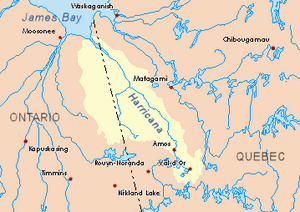
Harricana River basin in yellow
|
|
| Country | Canada |
| Province | Quebec |
| Physical characteristics | |
| Main source | Streams Baie-James, Jamésie, Quebec 263 m (863 ft) 50°09′51″N 79°13′05″W / 50.16417°N 79.21806°W |
| River mouth | Harricana River Baie-James, Jamésie, Quebec 44 m (144 ft) 50°36′10″N 79°11′14″W / 50.60278°N 79.18722°W |
| Length | 61.1 km (38.0 mi) |
| Basin features | |
| Tributaries |
|
The Breynat River is a river in Quebec, Canada. It flows into the Harricana River. It's located in the Nord-du-Québec region, near a place called Baie-James.
The river usually freezes over from early November to mid-May. It's generally safe to be on the ice from mid-November to the end of April.
Contents
Where is the Breynat River?
The Breynat River is surrounded by other rivers and areas. Here are some of the main ones:
- To the north: The Harricana River and the Joncas River.
- To the east: The Harricana River, Joncas River, and the Despreux River.
- To the south: The Turgeon River and the Martigny River.
- To the west: The Malouin River and the River Mannerelle.
Where Does the River Start?
The Breynat River begins from a small forest stream. This stream is about 263 meters (863 feet) above sea level. It's located in the Martigny Township, within the Eeyou Istchee Baie-James (Municipality). It's found northwest of a lake called "Lac aux Épices," which means "Spices Lake."
The starting point of the Breynat River is:
- About 1 kilometer (0.6 miles) north of "Lac aux Épices."
- About 20.6 kilometers (12.8 miles) west of the Harricana River.
- About 4.6 kilometers (2.9 miles) southeast of where the Malouin River starts.
- About 18.6 kilometers (11.6 miles) east of the border with Ontario.
How Does the River Flow?
The Breynat River flows for about 61.1 kilometers (38 miles). It generally runs alongside the Harricana River.
Here's how it flows:
- It starts by flowing north for about 0.3 kilometers (0.2 miles).
- Then, it continues north for about 15.4 kilometers (9.6 miles), where another stream joins it from the south.
- It flows north again for about 10.1 kilometers (6.3 miles), meeting another stream from the southeast.
- Next, it goes north for about 4.4 kilometers (2.7 miles) to the outlet of Lake Breynat.
- It then travels north for about 17.9 kilometers (11.1 miles), turning northeast and winding a bit. Another stream joins it from the south.
- Finally, it flows north for about 13.0 kilometers (8.1 miles) through a marshy area. It crosses the "Rapides des Roches Rouges" (Red Rocks Rapids) before reaching its end.
Where Does the River End?
The Breynat River empties into the western side of the Harricana River.
Its mouth (where it ends) is located:
- About 5.0 kilometers (3.1 miles) downstream from "Île des Sept Milles" (Island of Seven Miles).
- About 78.3 kilometers (48.7 miles) southeast of the Harricana River's own mouth.
- About 23.4 kilometers (14.5 miles) east of the Ontario border.
- About 145.3 kilometers (90.3 miles) northwest of downtown Matagami.
What's in a Name?
The name "rivière Breynat" was officially recognized on December 5, 1968. This happened when the Commission de toponymie du Québec (Quebec's Place Names Commission) was first created.
 | Lonnie Johnson |
 | Granville Woods |
 | Lewis Howard Latimer |
 | James West |

