Despreux River facts for kids
Quick facts for kids Despreux |
|
|---|---|

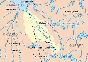
Harricana River basin in yellow
|
|
| Country | Canada |
| Province | Quebec |
| Region | Nord-du-Québec |
| Physical characteristics | |
| Main source | Eeyou Istchee Baie-James (municipality), Nord-du-Québec, Quebec 261 m (856 ft) 50°10′32″N 79°04′53″W / 50.17556°N 79.08139°W |
| River mouth | Harricana River Eeyou Istchee Baie-James (municipality), Nord-du-Québec, Quebec 97 m (318 ft) 50°30′54″N 79°08′14″W / 50.51500°N 79.13722°W |
| Length | 44.7 km (27.8 mi) |
The Despreux River is a river in Quebec, Canada. It flows into the Harricana River. This river is located in the Nord-du-Québec region, specifically in the area known as Jamésie.
Like many rivers in this cold region, the Despreux River usually freezes over. Its surface is frozen from early November until mid-May. However, it's generally safe to walk or move on the ice from mid-November to the end of April.
Contents
Where is the Despreux River?
The Despreux River is found in a large area called Eeyou Istchee Baie-James (municipality). This municipality is part of the Nord-du-Québec region in Quebec.
River's Neighbors
Rivers often have "neighbors" – other rivers or streams nearby. Here are some of the main rivers close to the Despreux River:
- North: Breynat River, Harricana River, Joncas River
- East: Harricana River, Joncas River
- South: Turgeon River (Eeyou Istchee James Bay), Martigny River
- West: Breynat River, Malouin River, Mannerelle River
Where the River Starts
Every river starts somewhere! The Despreux River begins from a small forest stream. This starting point is called its source. The source is located in the municipality of Eeyou Istchee James Bay. It is quite high up, at about 261 metres (856 ft) (about 856 feet) above sea level.
The source of the Despreux River is:
- 8.5 kilometres (5.3 mi) (about 5.3 miles) west of the Harricana River.
- 15.1 kilometres (9.4 mi) (about 9.4 miles) east of where the Malouin River starts.
- 30.5 kilometres (19.0 mi) (about 19 miles) east of the border with Ontario.
The River's Journey
From its source, the Despreux River flows for about 44.7 kilometres (27.8 mi) (about 27.8 miles). It takes a few turns along the way:
- First, it flows about 15.4 kilometres (9.6 mi) (about 9.6 miles) north. It passes a place where water from Lake Despreux flows into it.
- Then, it continues north for another 24.9 kilometres (15.5 mi) (about 15.5 miles). Here, a small creek joins the river from the south.
- Finally, it flows about 4.4 kilometres (2.7 mi) (about 2.7 miles) northeast until it reaches its mouth.
Where the River Ends
The Despreux River ends by flowing into the Harricana River. This meeting point is called the river's mouth. It joins the Harricana River on its west bank, near a place called the Island of Seven Mile.
The mouth of the Despreux River is:
- 88.6 kilometres (55.1 mi) (about 55 miles) southeast of where the Harricana River itself ends.
- 26.9 kilometres (16.7 mi) (about 16.7 miles) east of the Ontario border.
- 136 kilometres (85 mi) (about 84.5 miles) northwest of the town of Matagami, Quebec.
What's in a Name?
The word toponymy means the study of place names. The name "Despreux River" was officially recognized on December 5, 1968. This happened when the Commission de toponymie du Québec was created. This commission is responsible for naming places in Quebec.
 | Selma Burke |
 | Pauline Powell Burns |
 | Frederick J. Brown |
 | Robert Blackburn |

