Malouin River facts for kids
Quick facts for kids Malouin |
|
|---|---|

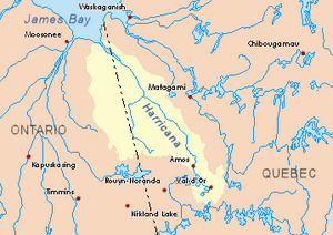
Harricana River basin in yellow
|
|
| Country | Canada |
| Province | Quebec |
| Region | Nord-du-Québec |
| Physical characteristics | |
| Main source | Eeyou Istchee Baie-James (municipality), Nord-du-Québec, Quebec 264 m (866 ft) 50°11′42″N 79°18′00″W / 50.19500°N 79.30000°W |
| River mouth | Turgeon River (Eeyou Istchee Baie-James) Eeyou Istchee Baie-James (municipality), Nord-du-Québec, Quebec 34 m (112 ft) 50°42′03″N 79°19′23″W / 50.70083°N 79.32306°W |
| Length | 67.2 km (41.8 mi) |
The Malouin River is a river in Quebec, Canada. It flows into the Harricana River. The river is located in the area called Eeyou Istchee Baie-James (municipality), which is part of the Nord-du-Québec region. The river flows through two areas known as Massicotte and Manthet.
The Malouin River usually freezes over in early November. It stays frozen until mid-May. However, it's generally safe to be on the ice from mid-November to the end of April.
Contents
Where is the Malouin River?
This section explains where the Malouin River is located and which other rivers are nearby.
Nearby Rivers and Waterways
The Malouin River is surrounded by several other important rivers. These are called its "hydrographic slopes." Think of them as neighboring river systems.
- North side: The Harricana River and the Mannerelle River.
- East side: The Harricana River, the Breynat River, and the Despreux River.
- South side: The Turgeon River (Eeyou Istchee James Bay) and the Detour River.
- West side: The Again River (which flows in both Ontario and Quebec), the Lawagamau River (in Ontario), and the Mannerelle River.
The River's Starting Point
The Malouin River begins from a small forest stream. This starting point is about 264 metres (866 ft) (or about 866 feet) above sea level. It is located in the southern part of the Eeyou Istchee James Bay (municipality) area.
The source of the Malouin River is:
- About 21.5 kilometres (13.4 mi) (13.4 miles) west of the Harricana River.
- About 56.4 kilometres (35.0 mi) (35 miles) south of where the Malouin River ends (its mouth).
- About 16.5 kilometres (10.3 mi) (10.3 miles) west of the border with Ontario.
How the River Flows
The Malouin River flows for about 67.2 kilometres (41.8 mi) (41.8 miles). It flows mostly parallel to the Ontario border. Here's how its journey unfolds:
- For 25.2 kilometres (15.7 mi) (15.7 miles), it flows north through a marshy area until it reaches a bend.
- Then, for 17.1 kilometres (10.6 mi) (10.6 miles), it continues north through another marshy area, reaching a small creek that joins it from the southeast.
- Next, it flows 5.6 kilometres (3.5 mi) (3.5 miles) north through a marshy zone until it meets the Mannerelle River.
- Finally, it flows 19.3 kilometres (12.0 mi) (12 miles) north through a marshy area until it reaches its mouth.
Where the River Ends
The Malouin River flows into the southwestern side of the Harricana River. Here are some distances from its mouth:
- It is 32.8 kilometres (20.4 mi) (20.4 miles) upstream from Low Shoal Island, which is in Ontario.
- It is 64.3 kilometres (40.0 mi) (40 miles) southeast of where the Harricana River itself ends.
- It is 14.1 kilometres (8.8 mi) (8.8 miles) east of the Ontario border.
- It is 158 kilometres (98 mi) (98.2 miles) northwest of the center of Matagami.
The Name of the River
This section explains how the Malouin River got its name.
Honoring a Surveyor
The name "Malouin River" honors the life and work of a surveyor named Paul Malouin (1884-1945). He was born in Quebec City. Paul Malouin studied at the School of Surveying at Laval University starting in 1904. He became a certified surveyor in 1910. That same year, he started a business with another surveyor, Paul Joncas, called "Joncas and Malouin."
Early Names and Formalization
The name "Malouin River" was shown on a regional map of the Abitibi area in 1962. This map was made by the Department of Lands and Forests.
Before that, in 1895, an explorer named Henry O'Sullivan discovered this river. He named it "Rivière du Mariage" (which means "The River of Marriage") or "Birthday." He chose this name because he found the river on September 15, which was his 20th wedding anniversary.
The name "Malouin River" was officially recognized on December 5, 1968. This happened when the Commission de toponymie du Québec (Quebec's Place Names Commission) was created.
 | Audre Lorde |
 | John Berry Meachum |
 | Ferdinand Lee Barnett |

