Albany River facts for kids
Quick facts for kids Albany River |
|
|---|---|

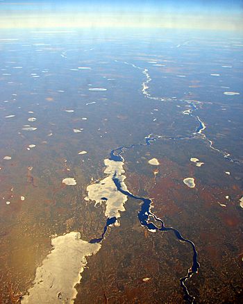
The Albany river between the Eabametoong First Nation (out of picture), and Marten Falls First Nation in the far distance downstream
|
|
|
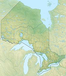
Location of the mouth of the Albany River in Ontario
|
|
| Country | Canada |
| Province | Ontario |
| Region | Northern Ontario |
| Districts |
|
| Physical characteristics | |
| Main source | Lake St. Joseph 371 m (1,217 ft) 51°11′40″N 90°13′20″W / 51.19444°N 90.22222°W |
| River mouth | James Bay Akimiski Strait 0 m (0 ft) 52°17′00″N 81°30′59″W / 52.28333°N 81.51639°W |
| Length | 982 km (610 mi) |
| Basin features | |
| River system | James Bay drainage basin |
| Basin size | 135,200 km2 (52,200 sq mi) |
| Tributaries |
|
The Albany River is a long river in Northern Ontario, Canada. It starts at Lake St. Joseph and flows northeast. Finally, it empties into James Bay.
This river is about 982 kilometres (610 mi) long. This makes it one of the longest rivers in Ontario, just like the Severn River. Some important rivers that flow into the Albany River are the Kenogami River and the Ogoki River.
The river got its name from James, Duke of York and Albany. He later became King James II of England.
Contents
Where Does the Albany River Flow?
The Albany River begins at Lake St. Joseph. This lake is about 371 metres (1,217 ft) above sea level. From there, the river flows past the Rat Rapids dam. It also goes under Ontario Highway 599 into Osnaburgh Lake.
The river then splits into different paths around Kagami Island. It picks up water from smaller rivers like the Misehkow River and the Etowamami River. The Albany River also flows over waterfalls like Upper Eskakwa Falls and Snake Falls.
Finally, the river reaches James Bay through many channels. The community of Fort Albany is on one of these channels. The Kashechewan First Nation is on another channel nearby. You can travel by boat on the first 400 kilometres (249 mi) of the river.
The Albany River's Watershed
A watershed is an area of land where all the water drains into one river or lake. The Albany River's watershed covers a huge area of 135,200 square kilometres (52,201 sq mi). This means a lot of water flows into it! On average, about 1,420 cubic metres (50,147 cu ft) of water flows through the river every second.
For much of its journey, the Albany River forms a natural border. It separates the Kenora District from the Thunder Bay and Cochrane Districts.
Water Diversions
Sometimes, water is moved from one river system to another. This is called a diversion. There are three main diversions in the Albany River watershed. These diversions help with hydroelectric projects, which create electricity using water power.
- Some water from the Ogoki River is sent towards Lake Superior.
- Water from the Kenogami River's source is also sent towards Lake Superior.
- Water from Lake St. Joseph is diverted into the English River. This water eventually flows into Hudson Bay.
History of the Albany River

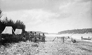
Because the Albany River reaches far to the west, its mouth was a great spot for trading posts. These posts were places where people could trade goods. For a long time, there was competition between the English and the French over trade in this area. The English came from Hudson Bay, and the French came from the Great Lakes.
French traders, known as coureurs des bois, explored much of the Albany River area early on. In 1674, Charles Bayly of the Hudson's Bay Company was the first European to see the Albany River. Before 1679, the Hudson's Bay Company built Fort Albany at the river's mouth.
Over the years, other trading posts were built along the river:
- In 1685, the French built Fort des Français.
- In 1743, Henley House was set up about 160 miles upriver.
- In 1777, Glouster House was built even further up.
- Around 1786, Osnaburgh House was built near Lake St. Joseph.
By the 1790s, trade from Fort Albany reached all the way to Lake Winnipeg. The land north of the Albany River used to be part of the Northwest Territories. But in 1912, it became part of Ontario.
Economy and Parks
A special provincial waterway park has been created on the Albany River. This park is located north of Wabakimi Provincial Park. It helps protect the river and its natural beauty.
Rivers that Join the Albany River
Many smaller rivers flow into the Albany River. These are called tributaries.
- Pagashi River (on the left side)
- Cheepay River (on the right side)
- Henley River (on the left side)
- Streatfeild River (on the right side)
- Kenogami River (on the right side)
- Ogoki River (on the right side)
- Shabuskwia River (on the right side)
- Etowamami River (on the left side)
- Misehkow River (on the right side)
- Lake St. Joseph (where the river starts)
- Cat River (flows into Lake St. Joseph)
Communities Along the River
Several communities are located along the Albany River or very close to it:
- Kashechewan First Nation
- Fort Albany
- Ghost River (where the Cheepay River joins)
- Ogoki Post (part of Marten Falls First Nation)
- Eabametoong First Nation / Fort Hope (connected by the Eabamet River)
- Osnaburgh (part of Mishkeegogamang First Nation)
See also
 In Spanish: Río Albany para niños
 | Kyle Baker |
 | Joseph Yoakum |
 | Laura Wheeler Waring |
 | Henry Ossawa Tanner |


