Severn River (northern Ontario) facts for kids
Quick facts for kids Severn River |
|
|---|---|

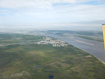
Severn River near its mouth at Fort Severn
|
|
|
Location of the mouth of Severn River in Ontario
|
|
| Country | Canada |
| Province | Ontario |
| Physical characteristics | |
| Main source | Deer Lake Deer Lake, Kenora District 310 m (1,020 ft) 52°40′N 94°25′W / 52.667°N 94.417°W |
| River mouth | Hudson Bay Fort Severn 55°59′N 87°38′W / 55.983°N 87.633°W |
| Length | 982 km (610 mi) |
| Basin features | |
| River system | Hudson Bay drainage basin |
| Basin size | 102,800 km2 (39,700 sq mi) |
The Severn River is a very long river in northern Ontario, Canada. It starts near the western edge of the province. The river stretches for about 982 kilometers (610 miles). Its waters drain a huge area of land, about 102,800 square kilometers (39,700 square miles). A small part of this area is in Manitoba.
The Severn River begins at Deer Lake. From there, it flows northeast into Severn Lake. After that, it continues its journey to Hudson Bay. The river finally empties into the bay at a place called Fort Severn.
Contents
Communities Along the River
Several First Nations communities are located along the Severn River. These include Sandy Lake, Bearskin Lake, and Fort Severn. These communities grew up around old trading posts. These posts were very important during the time of the fur trade. The Severn River was a key route for trade back then.
At the very start of the river, near Deer Lake, is the small community of Deer Lake, Ontario.
Fort Severn: A Place of History
Fort Severn is located right where the river meets Hudson Bay. It was first set up as a trading post in 1689. The Hudson's Bay Company built it to trade furs.
However, in 1690, a French explorer named Pierre Le Moyne d'Iberville captured the post. Later, in 1759, the trading post was rebuilt. It has been open and active ever since. This makes Fort Severn one of the oldest European settlements in Ontario that is still in use today.
Rivers That Join the Severn
Many smaller rivers flow into the Severn River. These are called tributaries. They add their water to the main river as it flows towards Hudson Bay.
Here are some of the rivers that join the Severn River:
- McInness River
- Cobham River (this river starts in Manitoba)
- Windigo River
- Makoop River
- Blackbear River
- Sachigo River
- Wapaseese River
- Beaver Stone River
- Fawn River
- Beaver River
See also
 In Spanish: Río Severn (bahía de Hudson) para niños
 | Misty Copeland |
 | Raven Wilkinson |
 | Debra Austin |
 | Aesha Ash |


