Kenogami River facts for kids
Quick facts for kids Kenogami River |
|
|---|---|

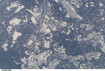
Kenogami River from the International Space Station (diagonally at upper left corner)
|
|
|
Location of the mouth of the Kenogami River in Ontario
|
|
| Country | Canada |
| Province | Ontario |
| Region | Northern Ontario |
| Districts |
|
| Physical characteristics | |
| Main source | Long Lake Longlac, Town of Greenstone, Thunder Bay District 311 m (1,020 ft) |
| River mouth | Albany River 75 m (246 ft) 51°06′22″N 84°28′54″W / 51.10611°N 84.48167°W |
| Length | 320 km (200 mi) |
| Basin features | |
| River system | James Bay drainage basin |
| Tributaries |
|
The Kenogami River is a river in Northern Ontario, Canada. It is part of the James Bay drainage basin, which means its waters eventually flow into James Bay. The river starts at Long Lake near Longlac and flows north. It then empties into the Albany River. The Kenogami River is about 320 kilometers (200 miles) long. Its name comes from the Cree language and means "long water." A small part of the river's starting waters has been redirected to flow into the Lake Superior drainage basin instead.
River's Journey
The Kenogami River begins at Longlac Bay on Long Lake. This is near the community of Longlac, which is part of Greenstone. From there, the river flows under Ontario Highway 11 and the Canadian National Railway tracks.
As it continues, the Kenogami River is joined by smaller rivers called tributaries. These include the Kenogamisis River and Burrows River. The river then reaches the Kenogami Lake Dam. It keeps flowing northeast and is joined by the Kawakanika River.
The river then enters Cochrane District and is joined by the Fernow River and Wabigano River. It passes under an old railway line before meeting the Atikasibi River. The Kenogami River continues its journey, collecting water from many more tributaries like the Mundino River, Flint River, Watistiguam River, and Nemasa River.
Further along, it meets the Pagwachuan River, and then, very close together, the Nagagami River and the Kabinakagami River. The Kabinakagami River joins the Kenogami near Mammamattawa. This area was once home to an old trading post.
Finally, the Kenogami River turns north. It flows past the English River 66 First Nations Reserve. It is joined by more tributaries, such as the Ash River and Kingfisher River, and the Drowning River. The Kenogami River then reaches its end at a place called The Albany Forks, where it joins the Albany River. The Albany River then flows into James Bay.
River History
The first trading post built far inland by the Hudson's Bay Company was called Henley House. It was set up in 1743 where the Kenogami River meets the Albany River.
Later, in 1884, a new trading post was built at Mammamattawa, Ontario. This was where the Kenogami River and the Kabinakagami River meet. This post was known as the English River Post because the Kenogami River was also sometimes called the English River.
Long Lake Diversion Project
Between 1937 and 1938, a big project was completed by the Hydro-Electric Power Commission of Ontario, which is now called Ontario Power Generation. They built the Kenogami Lake Dam and the Long Lake Diversion Dam.
The goal of this project was to change the flow of some of the Kenogami River's starting waters. Instead of flowing towards James Bay, these waters were redirected through Long Lake and the Aguasabon River into Lake Superior. The Kenogami Lake Dam held back the water, and the Long Lake Diversion Dam controlled how much water flowed into the Aguasabon River.
This change moved a large amount of water, about 1,377 cubic feet (39 cubic meters) per second, from the James Bay area to the Great Lakes Basin. This diversion helped with forestry (logging) and creating hydroelectric power further downstream on the Great Lakes, especially near Niagara Falls.
In 1948, another part of the project was finished. This included the Hayes Lake Dam and the Aguasabon Generating Station. These were built to help power a pulp and paper mill in the nearby town of Terrace Bay.
Tributaries
- Little Current River (joins from the left)
- Drowning River (joins from the left)
- Little Drowning River (joins from the left)
- Wakashi River (joins from the right)
- Kingfisher River (joins from the left)
- Ash River (joins from the left)
- Little Ash River (joins from the left)
- Kabinakagami River (joins from the right)
- Nagagami River (joins from the right)
- Pagwachuan River (joins from the right)
- Nemasa River (joins from the left)
- Watistiguam River (joins from the left)
- Flint River (joins from the right)
- Mundino River (joins from the left)
- Atikasibi River (joins from the left)
- North Barlow Creek (joins from the right)
- Wabigano River (joins from the right)
- Fernow River (joins from the right)
- Chipman Lake
- Jobrin Creek (joins from the left)
- Pardee Creek (joins from the right)
- Kawakanika River (joins from the left)
- Burrows River (joins from the left)
- Kenogamisis River (joins from the left)
- Blueberry Creek (joins from the right)
- Isis Creek (joins from the left)
 | Kyle Baker |
 | Joseph Yoakum |
 | Laura Wheeler Waring |
 | Henry Ossawa Tanner |


