
Aguasabon River facts for kids
Quick facts for kids Aguasabon River |
|
|---|---|

Aguasabon Gorge and Falls near Terrace Bay
|
|

Location of the mouth of the Aguasabon River in Ontario
|
|
| Country | Canada |
| Province | Ontario |
| District | Thunder Bay |
| Physical characteristics | |
| Main source | Chorus Lake 395 m (1,296 ft) 49°14′12″N 87°09′43″W / 49.23667°N 87.16194°W |
| River mouth | Lake Superior Terrace Bay 180 m (590 ft) 48°46′22″N 87°07′00″W / 48.77278°N 87.11667°W |
| Length | 70 km (43 mi) |
| Basin features | |
| River system | Great Lakes Basin |
The Aguasabon River is a river located in the Thunder Bay District of Ontario, Canada. It begins at Chorus Lake and flows into Lake Superior near the community of Terrace Bay. This river is about 70 kilometres (43 mi) long.
The Aguasabon River is known for its beautiful Aguasabon Falls. Here, the water plunges down 30 metres (98 ft)! The river flows over very old rocks. These rocks are about 2.6 billion years old and are a type called granodiorite.
Contents
History of the Aguasabon River
When the Canadian Pacific Railway was being built between 1882 and 1885, this river was called the Black River. It was located 857 miles from Montreal. This is not to be confused with another river called the Black River near Heron Bay.
Aguasabon Hydroelectric Station
The Aguasabon Station is a special place on the river. It has a dam and a power plant. This plant uses the river's water to create hydroelectric power. It is run by Ontario Power Generation.
How the Power Plant Works
The power plant has two units that generate electricity. This electricity helps power a Kimberly-Clark pulp and paper plant in Terrace Bay. It's a great example of how we can use natural resources to create energy.
Building the Station
In 1945, a group called the Hydro-Electric Power Commission of Ontario started planning this power plant. Construction began in 1946 and the plant opened in 1948. Building it took a lot of work. People worked for five million hours!
They also built many roads and 25 buildings. These included homes for staff, a hospital, and offices. The dam made Hays Lake much bigger, about 500 times its original size. This meant that Ontario Highway 17 had to be moved, and a new bridge was built.
Changing River Flow
As part of this big project, the Hydro-Electric Power Commission of Ontario changed the direction of the Kenogami River. Before, the Kenogami River flowed north towards Hudson Bay. Now, its upper waters flow south into Long Lake. From there, the water joins the Aguasabon River system and flows into Lake Superior. This was a major change to the natural flow of the rivers.
Images for kids
-
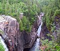
Aguasabon Gorge and Falls
