
Rupert River facts for kids
Quick facts for kids Rupert River |
|
|---|---|
 |
|

Rupert River original basin in yellow and orange, diverted basin in orange
|
|
| Native name | Rivière Rupert |
| Country | Canada |
| Province | Quebec |
| Region | Nord-du-Québec |
| Physical characteristics | |
| Main source | Lake Mistassini 50°57′0″N 73°42′0″W / 50.95000°N 73.70000°W |
| River mouth | Rupert Bay Waskaganish 51°29′0″N 78°46′0″W / 51.48333°N 78.76667°W |
| Length | 763 km (474 mi) |
| Discharge (location 2) |
|
| Basin features | |
| Basin size | 43,400 km2 (16,800 sq mi) |
| Tributaries |
|
The Rupert River is a very long river in Quebec, Canada. It starts in Lake Mistassini, which is the biggest natural lake in Quebec. From there, it flows about 556 kilometres (345 mi) west. It ends in Rupert Bay, which is part of James Bay. The Rupert River and all its smaller rivers drain an area of about 43,400 square kilometres (16,800 sq mi).
Contents
Exploring the Rupert River's Waters
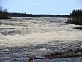
The Rupert River has some really exciting and powerful whitewater sections. Whitewater means the water is very rough and bubbly, like rapids. If people are paddling canoes, they can often go around these rough spots. This is called a portage, where you carry your boat and gear over land.
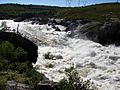
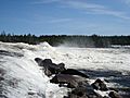
Two of the most impressive waterfalls on the river are the "Oatmeal Rapids" and "The Fours." The Oatmeal Rapids are near the James Bay Road and drop about 18 m (59 ft). "The Fours" are closer to the end of the river and have a 24 m (79 ft) drop! These big drops are usually avoided by portaging.
A River of History and Culture
For a very long time, the Rupert River has been super important to the Cree people who live in the area. Every year, young Cree people from the village of Waskaganish, which is right at the mouth of the Rupert River, travel up the river to Lake Nemiscau. This journey helps them connect with their traditions.
Key Rivers Joining the Rupert
Many smaller rivers flow into the Rupert River. These are called tributaries. Here are some of the main ones:
- Natastan River (also called Rivière Natastan)
- Lemare River (Rivière Lemare)
- Marten River (Rivière à la Marte)
- Nemiscau River (Rivière Nemiscau)
The Rupert River's Past
In 1668, a group led by Médard des Groseilliers arrived at the mouth of the Rupert River. They wanted to find a new way to trade furs without going through areas controlled by the French. They named the river after Prince Rupert of the Rhine, who helped pay for their trip.
They built a fort there, first called Fort Charles. This fort later became a trading post known as Rupert House. It was the very first trading post for the Hudson's Bay Company, a famous trading company. The Rupert River was super important for bringing supplies to other trading posts further inland, like Nemiscau and Mistissini. People used canoe brigades, which were groups of canoes carrying goods, to move things along the river. This continued until the early 1900s, when trains and roads started to be used instead.
Even though it's not a main trade route anymore, the Rupert River is still a popular place. People love to go canoe camping and enjoy whitewater canoeing there.
Image gallery
-
The Rupert River at the Route du Nord
-
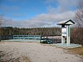
A great spot to view the Rupert River
-
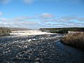
The Rupert River near the James Bay Road.
-
A close-up view of the Oatmeal Rapids


,_Oatmeal_Rapids.jpg)
Images for kids
-
The Oatmeal Rapids on the Rupert River.

See also
 In Spanish: Río Rupert para niños
