Nemiscau River facts for kids
Quick facts for kids Nemiscau River |
|
|---|---|

Watershed of Rupert River
|
|
| Country | Canada |
| Province | Quebec |
| Region | Nord-du-Québec |
| Physical characteristics | |
| Main source | Eeyou Istchee Baie-James, Nord-du-Québec, Quebec 1,191 m (3,907 ft) 52°2′40″N 74°55′20″W / 52.04444°N 74.92222°W |
| River mouth | Lake Nemiscau Eeyou Istchee Baie-James, Nord-du-Québec, Quebec, Canada 50°14′44″N 73°48′57″W / 50.24556°N 73.81583°W |
| Length | 180 km (110 mi) |
| Basin features | |
| Basin size | 3,015 km2 (1,164 sq mi) |
The Nemiscau River is a river located in Quebec, Canada. It flows through the Nord-du-Québec region, which is a large area in northern Quebec. This river is an important part of the local geography and history.
Contents
Where is the Nemiscau River?
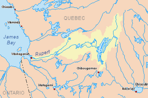
The Nemiscau River flows into Lake Nemiscau. It travels for over 100 kilometers (about 62 miles) from the northeast to the southwest. The river passes just south of a small community called Nemaska.
How Does the River Start?
The Nemiscau River begins from several lakes located east and southeast of the Eastmain Reservoir. The highest point where the river starts is about 450 meters (1,476 feet) high. As the river flows, it goes through many lakes and marshy areas. Some of these lakes include Cramoisy, Teilhard, Biggar, and Mountains.
What Rivers are Nearby?
The Nemiscau River is surrounded by other important water bodies.
- To the north, you'll find the Pontax River, Eastmain River, and the Eastmain Reservoir.
- To the south, there is the Rupert River.
- To the west, the river reaches Lake Nemiscau.
Where Does the River End?
The Nemiscau River flows into the northern part of Lake Nemiscau. This lake has a unique "U" shape that opens towards the northeast. The Rupert River also flows into the other end of this "U" shaped lake. Lake Nemiscau is located north of Lake Giffard and Lake Evans, and south of Jolliet Lake.
The Story Behind the Name: Nemiscau
The name "Nemiscau" has a long and interesting history. It has been used for different rivers over time!
Early Explorers and River Names
In 1672, an explorer and Catholic priest named Charles Albanel called what we now know as the Rupert River "Nemiskausipiou." Later, in 1679, another famous explorer, Louis Jolliet, also used the name "Nemisco" for the Rupert River. Jolliet even wrote about how he traveled from the Saguenay River to a large lake called "Timigaming" (which is now Lake Mistassini). He mentioned that the "River Némiskau" (meaning the Rupert River) flowed from there into James Bay.
How the Name Nemiscau Moved
The name "Nemiscau" for the river we know today started being used in the 1940s. Before that, this river was not officially named. The name "Nemiscau" was originally linked to the Rupert River.
In 1982, the Commission de toponymie du Québec (which is like Quebec's official board for place names) made it official. They decided that this specific river would be called the "Rivière Nemiscau."
Old Maps and Different Names
Maps from 1690 started using the name "Rupert" for both the river and a fort. Later maps, like those by Claude-Charles Bacqueville de La Potherie and Father Laure, also used "R. Rupert." However, in 1744, Nicolas Bellin's maps still showed "R. Nemiscau."
Eventually, the name "Rupert River" became the most common name for that larger river until the 1900s. The name "Nemiscau" was then used again, but it moved northeast to identify the river that had been unnamed until the 1940s.
What Does Nemiscau Mean?
In the Cree language, the word "Nemiscau" means "where fish are abundant." This suggests that the area around the river has always been a good place for fishing!
Some old maps also show different names for rivers in this region. For example, a 1685 map by Alexis Jaillot shows "François R." And a 1703 map by Guillaume Delisle has "Miskoutenagachit." Another map from 1715 (revised in 1732) shows "Miskautenagachit R."
The official name Nemiscau River was formally added to the Quebec Names Board's list on December 2, 1982.
 | James Van Der Zee |
 | Alma Thomas |
 | Ellis Wilson |
 | Margaret Taylor-Burroughs |

