Saguenay River facts for kids
Quick facts for kids Saguenay River |
|
|---|---|

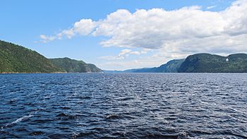
Saguenay River, inside the Saguenay–St. Lawrence Marine Park
|
|
 |
|
| Native name | Rivière Saguenay |
| Country | Canada |
| Province | Quebec |
| Region | Saguenay–Lac-Saint-Jean |
| Physical characteristics | |
| Main source | Lac Saint-Jean Alma, Saguenay–Lac-Saint-Jean 102 m 48°32′28″N 71°36′54″W / 48.54111°N 71.61500°W |
| River mouth | Saint Lawrence River Tadoussac / Baie-Sainte-Catherine, Côte-Nord / Capitale-Nationale 3 m 48°07′45″N 69°42′13″W / 48.12917°N 69.70361°W |
| Length | 170 km (110 mi) |
| Basin features | |
| Basin size | 88,000 km2 (34,000 sq mi) |
| Tributaries |
|
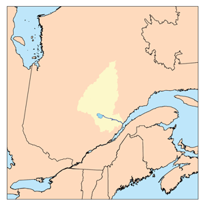
The Saguenay River (called Rivière Saguenay in French) is a very important river in Quebec, Canada. It starts from Lac Saint-Jean in the Laurentian Highlands. The river flows east from Alma and eventually joins the big Saint Lawrence River. The city of Saguenay is built along this river.
The Saguenay River flows very fast. It is surrounded by tall cliffs because it sits in a deep valley called the Saguenay Graben. Ocean tides can reach far up the river, all the way to Chicoutimi, which is about 100 kilometers (62 miles) inland.
Many Beluga whales come to the cold waters near the river's mouth to have their babies. This makes Tadoussac, a town at the river's end, a popular spot for whale watching and sea kayaking. You might even spot Greenland sharks in the deeper parts of the river. The area where the Saguenay meets the Saint Lawrence River is protected as the Saguenay–St. Lawrence Marine Park. This is one of Canada's national parks.
River History: A Journey Through Time
The Saguenay River has always been important. Long ago, First Nations people used it as a major path for trading deep into the land.
Fur Trade and French Settlement
When the French came to North America, the river became a key route for the fur trade. In 1600, the French set up their first trading post in Canada at Tadoussac. They named the river after a famous old story about a "Kingdom of Saguenay." The river also gave its name to the Saguenay Herald, a special title in Canada.
Industry and Power
Starting in the 1800s, people used the river for moving logs and for making paper. A large dam on the upper Saguenay River creates hydroelectricity. This power helps local factories, like those that make aluminum and paper.
The Saguenay Flood of 1996
From July 18 to 21, 1996, heavy rains caused the Saguenay's smaller rivers to flood. This event, known as the Saguenay Flood, was one of Canada's most expensive natural disasters. However, something unexpected happened: the flood covered the dirty river bottom with new, clean mud. Scientists later found that the old, polluted mud was no longer a danger to the river's ecosystems.
River Geography: Where the Saguenay Flows
The Saguenay River starts at Lac Saint-Jean in Alma.
River Channels and Dams
At Alma, the river splits into two channels: La Petite Décharge and La Grande Décharge. The Île Maligne hydroelectric plant is built on La Grande Décharge. The land between these two channels is part of Alma. Here, the water is fresh. Several bridges cross these channels. The Saguenay River truly begins when these two channels meet east of Alma. It forms a long, wide area, very different from the fast rapids and waterfalls that were there before dams were built.
Further downstream, at Shipshaw, Quebec, the Saguenay splits again. The Shipshaw hydroelectric station is on the northern part, and the Chute-à-Caron power plant is on the southern side. This is also where the Aluminum Bridge is located.
From Fresh to Saltwater
Between Chicoutimi and Jonquière, the two river parts come together to form the Saguenay we know best. From this point, boats can easily travel on the river. The name "Chicoutimi" actually means "how deep is it" in the Montagnais language. In downtown Chicoutimi, you can see the Dubuc bridge and the Sainte-Anne bridge.
Saltwater from the ocean reaches all the way to Chicoutimi. At Tadoussac, a ferry boat connects Tadoussac with Baie-Sainte-Catherine.
Main Tributaries
The Saguenay River has many smaller rivers that flow into it. Here are some of the most important ones, listed from the mouth of the Saguenay going upstream:
- Sainte-Marguerite River
- Saint-Jean River
- Ha! Ha! River
- Mars River
- Valin River
- Rivière du Moulin
- Chicoutimi River
- Shipshaw River
- Rivière aux Sables
- Lake Saint-Jean (which itself has many rivers flowing into it, like the Peribonka River, Mistassini River, and Ashuapmushuan River)
Towns Along the Saguenay
Many towns and cities are located along the Saguenay River, from its start to where it meets the ocean:
- Alma
- Saint-Charles-de-Bourget, Quebec
- Shipshaw, Quebec (now part of Saguenay)
- Jonquière (now part of Saguenay)
- Chicoutimi (now part of Saguenay)
- Saint-Fulgence, Quebec
- La Baie, Quebec (at the end of Ha! Ha! Bay, now part of Saguenay)
- Sainte-Rose-du-Nord, Quebec
- Rivière-Éternité, Quebec
- L'Anse-Saint-Jean, Quebec
- Petit-Saguenay, Quebec
- Sacré-Cœur
- Tadoussac, Quebec
- Baie-Sainte-Catherine, Quebec
See also
 In Spanish: Río Saguenay para niños
 | Kyle Baker |
 | Joseph Yoakum |
 | Laura Wheeler Waring |
 | Henry Ossawa Tanner |

