Saguenay Graben facts for kids
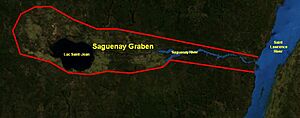
The Saguenay Graben is a special kind of valley in southern Quebec, Canada. It's like a long, flat-bottomed ditch in the Earth's crust. This valley is about 250 kilometers (155 miles) long and 50 kilometers (31 miles) wide. It formed when a large block of land dropped down between two long cracks in the Earth, called faults. Geologists call this type of valley a rift valley or a graben.
Contents
How the Saguenay Graben Formed
Scientists are still figuring out exactly when the Saguenay Graben was created. It's tricky to measure the age of these large cracks in the Earth. Some clues suggest it formed when a very old ocean, called the Iapetus Ocean, started to open up between 600 and 400 million years ago. Other clues point to the opening of the Atlantic Ocean about 195 to 170 million years ago.
During one of these times, the land began to pull apart. This pulling created two main cracks, or faults, one to the north and one to the south. The huge block of rock in between these two faults slowly sank downwards. This sinking created the deep valley we now call the Saguenay Graben. We only know where these faults are on the surface. How deep they go and their exact shape underground is still a mystery.
These faults are not just old cracks; they can still move. They have caused earthquakes in the past, like the one that happened near Saguenay in 1988.
Shaped by Ice: The Glaciers' Work
Over many thousands of years, huge sheets of ice, called glaciers, covered this area. This happened many times during the Pleistocene Ice Age. The Saguenay Graben was like a natural pathway for these moving ice sheets. This is because the valley ran in the same direction as the ice was flowing.
As the glaciers moved, they carved into the graben. They made some parts of the valley wider and other parts much deeper. When the last ice sheet finally melted away, the land slowly started to bounce back up. This process is called isostatic rebound. The land rose by different amounts: about 140 meters (460 feet) on the north side and 120 meters (390 feet) on the south side.
Saguenay Graben Today
The flat lands inside the Saguenay Graben are usually between 100 and 200 meters (330 to 660 feet) above sea level. To the east, there's a slightly higher area called the Kenogami threshold, which is about 200 to 260 meters (660 to 850 feet) high. This higher ground divides the graben into two main areas: the Lac Saint-Jean region in the west and the Saguenay region in the east. The land around the graben is much higher, ranging from 200 to 800 meters (660 to 2,600 feet) in altitude.
Two important water features are found within the Saguenay Graben: the Saguenay River and Lac Saint-Jean.
Rocks of the Saguenay Graben
The Saguenay Graben is located in a very old geological area called the Grenville Province. The rocks here are mostly very ancient, from the Proterozoic Eon. You can find types of rock like gneiss, anorthosite, and granite. Because of the way the graben formed with its faults, there are also two smaller areas of younger rocks. These are limestone and shale from the Paleozoic Era, which are only found within the graben itself.
 | William M. Jackson |
 | Juan E. Gilbert |
 | Neil deGrasse Tyson |


