
Rivière à Mars facts for kids
Quick facts for kids Rivière à Mars |
|
|---|---|
 |
|
| Country | Canada |
| Province | Quebec |
| Region | Capitale-Nationale and Saguenay-Lac-Saint-Jean |
| Regional County Municipality | Charlevoix Regional County Municipality, Le Fjord-du-Saguenay Regional County Municipality |
| Unorganized territory, municipality and city | Lac-Pikauba, Saguenay (city) |
| Physical characteristics | |
| Main source | Little unidentified lake Lac-Pikauba 869 m (2,851 ft) 47°44′42″N 70°57′45″W / 47.74512°N 70.962582°W |
| River mouth | Saguenay River Saguenay (ville) 72 m (236 ft) 48°20′09″N 70°52′47″E / 48.33583°N 70.87972°E |
| Length | 104.1 km (64.7 mi) |
| Basin features | |
| Tributaries |
|
The Rivière à Mars is a river in Quebec, Canada. It flows into the Baie des Ha! Ha!, which is part of the Saguenay River. This river is special because it's known for its Atlantic salmon.
The river starts in the Laurentides Wildlife Reserve. It flows through the area of Saguenay (city), especially the part called La Baie. The "Rivière à Mars" was greatly affected by a big flood that happened in July 1996.
The valley around the river is used for different activities. Roads like Route 381 follow the river. The main activity here is forestry, which means cutting down trees. Other activities include industry, shipping, and recreational tourism, like fishing.
The river usually freezes over from early December to late March. It's generally safe to walk on the ice from mid-December to mid-March.
Contents
River's Journey: From Source to Mouth
The Rivière à Mars starts from a small lake high up in the Laurentides Wildlife Reserve. It begins at about 869 meters (2,851 feet) above sea level. The river flows for about 104.1 kilometers (64.7 miles). Along its journey, the river drops a total of 797 meters (2,615 feet).
Most of the river flows through forests. However, the last 10.7 kilometers (6.6 miles) run through industrial and city areas before it reaches its end.
Upper River Course
The first part of the river's journey is about 38.1 kilometers (23.7 miles) long. It flows mostly north through a deep valley. It passes through Lac Turcotte and collects water from several other lakes and streams, like Lake Dusette and Lake Colon. This section of the river has many twists and turns.
Middle River Course
The middle part of the river is about 40.8 kilometers (25.4 miles) long and is still in a forest area. Here, the river continues to flow north and northwest. It passes by Mont aux Oiseaux, where an old fire tower once stood. It also meets other streams, including the Bras de l'Enfer (rivière à Mars) and the Bras d'Isaïe.
Lower River Course
The last part of the river, about 25.2 kilometers (15.7 miles) long, is also mostly in a forest area. In this section, the river flows northwest and then northeast. It crosses some rapids and goes under a railway bridge and a road bridge.
Finally, the Mars River flows into the Baie des Ha! Ha!. From there, the water travels about 11.0 kilometers (6.8 miles) northeast through the bay. Then, it joins the Saguenay River and flows east for about 99.5 kilometers (61.8 miles) until it reaches Tadoussac. At Tadoussac, the Saguenay River mixes with the larger Saint Lawrence estuary.
Aquatic Life: Salmon and Trout
The Rivière à Mars is famous for its fish, especially Atlantic salmon and sea trout. Sea trout are a type of brook trout that live in the ocean and return to fresh water to lay eggs. Fishing here is usually done by wading in the river and using a fly fishing rod. Only the first 7 kilometers (4.3 miles) of the river are easily accessible for fishing.
History of Fishing
For many years, from 1894 to 1935, a company called Price Brothers ran a private fishing club on the river. In 1930, a dam was built. This dam made it harder for salmon to swim upstream, but it helped float logs down the river until 1952.
After a lot of work to help the fish, including building a special "fishway" for salmon, a group called the Association of Sports Fishermen of the Mars River was started in 1983. Fishing was reopened in 1992.
Today, a group called Contact Nature Rivière-à-Mars manages fishing on the river. They also run a special place where you can learn about salmon and sea trout. You can even watch the salmon swim through the fishway using an underwater window!
River's Past: A Brief History
The name "Rivière à Mars" comes from one of the first settlers in the area, around the 1870s. His name was Mars Simard.
Here are some important moments in the river's history:
- 1888: A permit was given to build a wooden dam. It was used for a bakery to grind grain.
- 1930: Logs started to be floated down the river.
- 1934: A historical novel called Rivière à Mars was written by Damase Potvin.
- 1945: Log floating ended.
- 1983: The Association of Sports Fishermen of the River in Mars was founded.
- 1985: Sport fishing was closed for a while.
- 1985: A fishway was built to help salmon move upstream.
- 1992: Sport fishing for salmon started again.
- 1996: A big flood happened, destroying the fishway and the dam.
- 1997: The fishway and dam were rebuilt. Work was also done to stabilize the riverbanks.
- 2009: A big increase in the number of sea trout was observed.
- 2011: Repairs were made to the Roméo Tremblay dam.
Naming the River
The name "Rivière à Mars" was officially recognized on December 5, 1968, by the Quebec Place Names Bank.
Images for kids
-
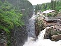
A canyon along the Rivière à Mars

Related Articles
- Charlevoix Regional County Municipality
- Le Fjord-du-Saguenay Regional County Municipality
- Laurentides Wildlife Reserve
- Zec de la Rivière-à-Mars, a controlled harvesting zone
- Zec Mars-Moulin, a controlled exploitation area
- Baie des Ha! Ha!
- Saguenay (city)
- Saguenay River
- Rivière à Mars North-West
- List of rivers of Quebec
