Baie des Ha! Ha! (Saguenay River) facts for kids
Quick facts for kids Baie des Ha! Ha! |
|
|---|---|
 |
|
| Lua error in Module:Location_map at line 416: Malformed coordinates value. | |

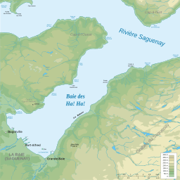
Map of the Baie des Ha! Ha!
|
|
| Location | Saguenay River, Quebec, Canada |
| Coordinates | Lua error in Module:Coordinates at line 614: attempt to index field 'wikibase' (a nil value). |
| Type | Bay |
| Max. length | 11 km (6.8 mi) |
| Max. width | 4.6 km (2.9 mi) |
| Surface area | 31 km (19 mi) |
The Baie des Ha! Ha! is a large bay, about 11 kilometers long, located on the Saguenay River in Quebec, Canada. It's part of the Saguenay–Lac-Saint-Jean region.
At the end of this bay, two rivers flow in: the Ha! Ha! River and Rivière à Mars. Long ago, people called this bay "Grande Anse" or "Grande Baie." Scientists believe this bay is connected to a big crack in the Earth's surface that also formed Kenogami Lake, which is nearby.
Contents
History of Baie des Ha! Ha!
For a very long time, even before settlers arrived in 1838, the Baie des Ha! Ha! was a special meeting place for First Nations people. Later, two villages grew near the bay. These villages eventually became part of the larger city of Saguenay.
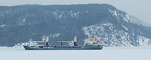
The bay is also important for shipping. Large ships carry bauxite, a material used to make aluminum, through the bay. This bauxite goes to factories in the area.
Since 2009, the bay has become a popular spot for cruise ships to visit. In winter, when the ice is thick, many people enjoy ice fishing here. In 1996, a big flood in the Saguenay area brought a lot of mud and sand into the bay.
What Does "Ha! Ha!" Mean?
The name Ha! Ha! doesn't mean someone is laughing! It probably comes from an old Montagnais language word. This word was hard to say in French and meant "place where bark is exchanged."
Some language experts think it might come from an old French word, haha. This word means "an unexpected obstacle on a path." But in the case of the bay, there isn't a clear obstacle.
Other places in the Saguenay-Lac-Saint-Jean region also use this interesting name:
- Ha! Ha! River
- Lake Ha! Ha!
- Petit lac Ha! Ha!
Geography of the Bay
The Baie des Ha! Ha! is a large inlet that stretches inland from the Saguenay River. It looks like a natural extension of the Saguenay fjord. The bay is about 11 km (6.8 mi) long and up to 4.6 km (2.9 mi) wide. Its surface is about 4 m (13 ft) above sea level.
From the Baie des Ha! Ha!, the Saguenay River flows for another 99.5 km (61.8 mi) eastward. It eventually reaches Tadoussac, where it joins the large Estuary of Saint Lawrence.
Animals of Baie des Ha! Ha!
Land Animals
Many animals that live near the Saguenay Fjord can also be found around the Baie des Ha! Ha!. These include:
- River otter
- American mink
- Pygmy weasel
- Long-tailed weasel
- Ermine
- Striped skunk
- Raccoon
- Muskrat
- Canadian Beaver
- Red fox
Water Animals
The Baie des Ha! Ha! and the Saguenay River are home to about 76 different kinds of fish. These include both freshwater and saltwater species. This is because the bay has two layers of water.
The top layer is slightly salty and comes from rivers flowing into the fjord. The bottom layer is cold, salty ocean water that slowly moves in from the Gulf of St. Lawrence with the tides. These two layers, separated by a special zone called a halocline, create a rich environment for many different kinds of life.
Some of the fish you might find here are:
- Brook trout
- Rainbow smelt
- Atlantic cod
- Sébaste (also known as redfish)
- Greenland shark
- Sea trout
- Lake sturgeon
- American eel
 | Lonnie Johnson |
 | Granville Woods |
 | Lewis Howard Latimer |
 | James West |


