Lake Ha! Ha! facts for kids
Quick facts for kids Lake Ha! Ha! |
|
|---|---|

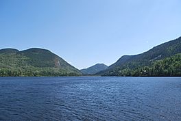
Surroundings of the lake
|
|
| Lua error in Module:Location_map at line 420: attempt to index field 'wikibase' (a nil value). | |
| Location | Saguenay / Lac-Ministuk / Larouche / Hébertville, Saguenay–Lac-Saint-Jean, Quebec |
| Primary inflows | Outlet of lake Michta, outlet of petit lac Ha! Ha!, Ha! Ha! River, outlet of lake Légal, Pierre River (Ha! Ha! River) |
| Primary outflows | Ha! Ha! River |
| Basin countries | Canada |
| Max. length | 7.0 km (4.3 mi) |
| Max. width | 1.4 km (0.87 mi) |
| Surface elevation | 379 m (1,243 ft) |
| Settlements | Ferland-et-Boilleau, Quebec |
Lake Ha! Ha! is a beautiful lake in Quebec, Canada. It's located in the Saguenay River valley. This lake is a source for the Ha! Ha! River.
A road called Route 381 runs near the lake. It even separates Lake Ha! Ha! from a smaller lake nearby, called petit lac Ha! Ha!. The area around the lake is very scenic, with mountains all around. Many people who love nature enjoy visiting this spot.
The main activity here is forestry, which means managing forests and cutting trees. Tourism, like people visiting for fun, is also important.
Lake Ha! Ha! usually freezes over in late November. It stays frozen until early April. You can safely walk or play on the ice from mid-December to late March.
About the Lake's Location
Lake Ha! Ha! is surrounded by several other rivers and lakes. These are like its neighbors in the water system.
- To the north, you'll find Huard Lake and parts of the Ha! Ha! River.
- To the east, there's John Creek and the Malbaie River.
- To the south, you'll see the Ha! Ha! River again, and the Pierre River.
- To the west, there's more of the Pierre River.
Lake Ha! Ha! is about 7.0 kilometres (4.3 mi) long. It has a unique crescent shape, like a moon, that opens towards the northeast. At its widest, it's about 1.4 kilometres (0.87 mi) across. The lake sits at an elevation of 379 metres (1,243 ft) above sea level.
The Ha! Ha! River flows through the lake for about 6.6 kilometres (4.1 mi). The Pierre River also flows into the lake from the west for about 3.2 kilometres (2.0 mi).
Water Flow and Journey
Lake Ha! Ha! gets its water from several places. Water flows in from Huard Lake, and from a few smaller streams. The Ha! Ha! River also flows into it from the southeast.
At the end of Lake Ha! Ha! there is a dam. This dam is located:
- About 2.7 kilometres (1.7 mi) south of the village of Boileau, Quebec.
- About 28.1 kilometres (17.5 mi) southeast of where the Ha! Ha! River meets the Baies des Ha! Ha! (Saguenay-Lac-Saint-Jean).
- About 43.2 kilometres (26.8 mi) southeast of downtown Saguenay, Quebec.
From this dam, the water flows down the Ha! Ha! River for about 34.8 kilometres (21.6 mi). Then, it enters the Baie des Ha! Ha! (Saguenay-Lac-Saint-Jean) for about 10.7 kilometres (6.6 mi). Finally, the water joins the mighty Saguenay River and travels about 87 kilometres (54 mi) east to Tadoussac. At Tadoussac, the Saguenay River flows into the huge St. Lawrence River.
Why the Name "Ha! Ha!"?
The name "Ha! Ha!" for the lake might sound funny, like someone laughing. But it actually has a different meaning!
Historians believe the name comes from an old French word, "haha." This word describes a hidden ditch or obstacle in a path. Imagine a ditch at the end of a garden path that stops you from going further – that's a "haha." It was also used in military terms for a ditch that blocked the entrance to a fort.
Another interesting idea comes from an old dictionary of the Huron language, published in 1632. In that dictionary, the word "Háhattey" meant "road" or "path."
The official name Lake Ha! Ha! was made formal on December 5, 1968, by the Commission de toponymie du Québec, which is like the official naming board for places in Quebec.
 | Toni Morrison |
 | Barack Obama |
 | Martin Luther King Jr. |
 | Ralph Bunche |


