Ha! Ha! River (Saguenay River tributary) facts for kids
Quick facts for kids Ha! Ha! River |
|
|---|---|
 |
|
 |
|
| Country | Canada |
| Province | Quebec |
| Region | Saguenay–Lac-Saint-Jean |
| Regional County Municipality | Le Fjord-du-Saguenay Regional County Municipality |
| City and protected area | Laurentides Wildlife Reserve, Ferland-et-Boilleau, Quebec, Saguenay, Quebec |
| Physical characteristics | |
| Main source | Montain and Forest streams Laurentides Wildlife Reserve 780 m (2,560 ft) 47°51′19″N 70°51′07″W / 47.85528°N 70.85194°W |
| River mouth | Saguenay River (via Baie des Ha! Ha!) Saguenay, Quebec, a city 4 m (13 ft) 48°19′04″N 70°51′35″W / 48.31778°N 70.85972°W |
| Length | 80.5 km (50.0 mi) |
| Basin features | |
| Tributaries |
|
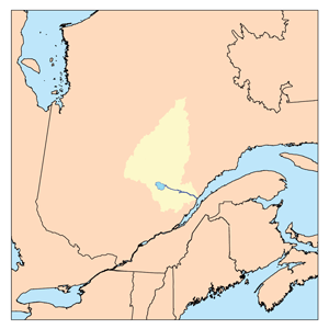
The Ha! Ha! River is a river located in Quebec, Canada. It flows through the Saguenay–Lac-Saint-Jean region. This river is special because of its unique name!
The river runs entirely within the Saguenay-Lac-Saint-Jean area. It passes through the town of Ferland-et-Boilleau, Quebec and the city of Saguenay, Quebec. The river was greatly affected by the Saguenay Flood, a big flood that happened in the region.
A road called Quebec Route 381 follows part of the river. It goes near Petit lac Ha! Ha! and Lake Ha! Ha!. This road helps people get around the river valley.
The main activity in the area is forestry, which means cutting down trees for wood. Tourism is also important, with people visiting for fun activities. Farming happens closer to the city areas along the river.
The Ha! Ha! River usually freezes over in winter. This happens from early December to late March. It's generally safe to walk on the ice from mid-December to mid-March.
Contents
Exploring the Ha! Ha! River's Path
The Ha! Ha! River is about 80.5 kilometers (50 miles) long. It starts high up in the mountains and flows down to the Saguenay River.
Where the River Begins
The Ha! Ha! River starts in the Laurentides Wildlife Reserve. It begins where several small forest streams meet. This spot is very high up, about 780 meters (2,560 feet) above sea level.
Rivers and Lakes Nearby
Many other rivers and lakes are close to the Ha! Ha! River.
- To the north, you'll find the Baie des Ha! Ha! and the big Saguenay River.
- To the east, there are lakes like Huard Lake and Éternité Lake.
- To the south, you'll see the Chemin des Canots River.
- To the west, there's the rivière à Pierre and rivière à Mars.
The River's Journey Downstream
From its source, the Ha! Ha! River flows mostly north.
- It starts by winding through a steep valley.
- It collects water from many smaller streams and lakes along the way.
- A big part of its journey includes flowing through Lake Ha! Ha!. This lake is about 7 kilometers (4.3 miles) long.
- After leaving Lake Ha! Ha!, the river continues its path. It passes through the villages of Ferland and Boileau.
- It also flows past the Huard River and the rivière des Cèdres, which are other rivers joining it.
- The river even has some waterfalls, like the falls at Gamelin.
- Finally, the Ha! Ha! River reaches its end. It flows into the Baie des Ha! Ha!. This bay is part of the larger Saguenay River system. The river's mouth is in the city of Saguenay, Quebec.
What's in a Name? The Ha! Ha! Mystery
The name Ha! Ha! for the river might make you think of laughing. But it actually comes from an old French word, ha-ha.
The Meaning of "Ha-ha"
In French, a "ha-ha" means an unexpected obstacle on a path. Imagine walking along and suddenly there's a ditch or a wall you didn't see coming. That's a "ha-ha"! It's a surprise. This name likely describes how the river or its surroundings might have surprised early explorers or travelers.
Other Places with "Ha! Ha!"
The Ha! Ha! name is used for other places in the Saguenay-Lac-Saint-Jean region too:
- Baie des Ha! Ha! (the bay where the river ends)
- Lake Ha! Ha! (a lake the river flows through)
- Petit lac Ha! Ha! (a smaller lake nearby)
 | Mary Eliza Mahoney |
 | Susie King Taylor |
 | Ida Gray |
 | Eliza Ann Grier |

