Rivière des Cèdres (Ha! Ha! River tributary) facts for kids
Quick facts for kids Rivière des Cèdres |
|
|---|---|
 |
|
| Country | Canada |
| Province | Quebec |
| Region | Saguenay–Lac-Saint-Jean |
| Regional County Municipality | Le Fjord-du-Saguenay Regional County Municipality |
| Municipality | Ferland-et-Boilleau |
| Physical characteristics | |
| Main source | Lac des Cèdres Ferland-et-Boilleau 232 m (761 ft) 48°02′11″N 70°46′21″W / 48.03647°N 70.77247°W |
| River mouth | Ha! Ha! River Ferland-et-Boilleau 168 m (551 ft) 48°07′43″N 70°48′55″E / 48.12861°N 70.81528°E |
| Length | 4.1 km (2.5 mi) |
| Basin features | |
| Tributaries |
|
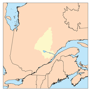
The Rivière des Cèdres is a small river in Quebec, Canada. It flows into the Ha! Ha! River. This river is located in the area of Ferland-et-Boilleau. It is part of the Saguenay–Lac-Saint-Jean region.
The valley around the Rivière des Cèdres is important for local activities. A main road, Route 381, helps people get to the area. This road follows the Ha! Ha! River and Lake Ha! Ha!. People use this area for cutting trees (forestry), farming, and fun outdoor activities. Smaller forest roads also help access the valley.
Forestry, which is harvesting trees, is the main way people make a living here. Tourism, like visiting for fun, is the second most important activity.
During winter, the Rivière des Cèdres usually freezes over. This happens from early December until the end of March. It is generally safe to walk or travel on the ice from mid-December to mid-March.
Contents
Where is the Rivière des Cèdres Located?
The Rivière des Cèdres is surrounded by several other important bodies of water. Knowing these helps understand its location.
Neighboring Waterways
- To the north: Crève-Cheval lake, "La Filée des Trois Petits Lacs", Thomas lake, and the large Saguenay River.
- To the east: "Lac de la Quenouille", "Lac des Pins", "Lac des Îlets", Brébeuf Lake, and Papinachois stream.
- To the south: The Ha! Ha! River, Lake Ha! Ha!, Lac Grand-Père, Huard River, Huard Lake, and Charny Lake.
- To the west: The Ha! Ha! River, rivière à Mars, Bras d'Hamel, and Bras Rocheux (Rocky arm).
The River's Journey
The Rivière des Cèdres begins at the mouth of Lac des Cèdres. This lake is about 6.4 kilometers (4 miles) long and 2.0 kilometers (1.2 miles) wide. It sits at an altitude of 232 meters (761 feet) above sea level.
The source of the river is located:
- About 1.5 kilometers (0.9 miles) south of Lac Crève-Cheval.
- About 3.3 kilometers (2.0 miles) northeast of where the Rivière des Cèdres joins the Ha! Ha! River.
From Lac des Cèdres, the Rivière des Cèdres flows for about 4.1 kilometers (2.5 miles). Here's how its journey goes:
- It flows southwest for 0.5 kilometers (0.3 miles) to a bay in "Lac à Doré".
- It then crosses "Lac à Doré" for 1.0 kilometer (0.6 miles). This lake is 2.0 kilometers (1.2 miles) long. It bends southeast to go around a mountain.
- Finally, it flows southwest for 2.6 kilometers (1.6 miles) through a deep valley until it reaches its mouth.
Where the River Ends
The Rivière des Cèdres flows into the Ha! Ha! River. This meeting point is on the east bank of the Ha! Ha! River.
This mouth is located:
- About 1.1 kilometers (0.7 miles) upstream from a dike on the Ha! Ha! River.
- About 6.5 kilometers (4.0 miles) south of the village of Ferland.
- About 9.2 kilometers (5.7 miles) southeast of where the Ha! Ha! River meets Baie des Ha! Ha!.
- About 27.6 kilometers (17.1 miles) southeast of downtown Saguenay.
From this point, the water flows along the Ha! Ha! River for about 13.3 kilometers (8.3 miles). It then crosses Baie des Ha! Ha! for 11.0 kilometers (6.8 miles). After that, it follows the Saguenay River for 99.5 kilometers (61.8 miles) east to Tadoussac. There, it joins the large Saint Lawrence estuary.
Why is it Called Rivière des Cèdres?
The name "Rivière des Cèdres" means "Cedar River" in French. It was officially named on December 5, 1968. This was done by the Commission de toponymie du Québec, which is a group that names places in Quebec.
 | Jewel Prestage |
 | Ella Baker |
 | Fannie Lou Hamer |

