
Saguenay Fjord National Park facts for kids
Quick facts for kids Saguenay Fjord National Park |
|
|---|---|
|
IUCN Category II (National Park)
|
|
 |
|

Saguenay Fjord National Park
Location in Quebec
|
|
| Location | Quebec, Canada |
| Nearest city | Saguenay, Quebec |
| Area | 319.3 square kilometres (123.28 sq mi) |
| Established | June 8, 1983 |
| Governing body | SEPAQ |
Saguenay Fjord National Park is a special park in Quebec, Canada. It's located along the eastern part of the Saguenay River. This park is next to the Saguenay–St. Lawrence Marine Park for more than 100 kilometers (60 miles).
The park was first called Saguenay National Park. Its name was changed on April 20, 2011. The new name helps everyone know about the amazing fjord it protects.
Contents
A Look Back: Park History
Long before Europeans arrived, Indigenous people lived in the Saguenay Fjord area. Groups like the Innus have called this place home for thousands of years.
The first European to visit was Jacques Cartier in 1535. Later, in 1608, Samuel de Champlain built a fort near what is now Quebec City. This led to many Indigenous groups, including Innu, Haudenosaunee, Huron, Algonquin, and Cree, trading along the Saguenay River. For many years, the fur trade was very important here.

In 1838, new settlers began to move into the Saguenay region. From 1840 to 1920, the area had a big lumber industry. However, by the late 1800s, many of the forests around the Saguenay River were gone. Because of this, and the tough landscape, the Saguenay area stayed mostly undeveloped for a long time.
In the 1970s, the Quebec government started buying land around the fjord. They wanted to protect this unique natural area. After public meetings in 1982, Saguenay National Park was officially created on June 8, 1983.
In 1984, the park became "twinned" with France's Cévennes National Park. This means they became partner parks. Over the years, new visitor facilities were added. On April 20, 2011, the park's name changed to Saguenay Fjord National Park. This new name highlights that it is one of the most southerly fjords in the Northern Hemisphere.
Exploring the Park's Geography
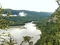
Saguenay Fjord National Park is located along the edge of its famous fjord. A fjord is a long, narrow, deep inlet of the sea between high cliffs. The Saguenay–St. Lawrence Marine Park is just to the southeast.

The Saguenay Fjord itself is about 105 kilometers (65 miles) long. It is between 2 and 4 kilometers (1 to 2.5 miles) wide. The fjord is very deep, averaging 210 meters (690 feet). Its deepest point is an amazing 270 meters (886 feet). The cliffs along the fjord are also very tall, averaging 150 meters (490 feet). Some cliffs reach a height of 350 meters (1,150 feet)!
The Saguenay Fjord flows into the St. Lawrence River. Interestingly, salt water from the St. Lawrence flows under a layer of fresh water from Lac St. Jean. This means 93% of the water in the fjord is salty.
The park has three main areas for visitors:
- Baie-Éternité: This area is in the southwest. You can reach it through the village of Rivière-Éternité. Here, you'll find the Saguenay Fjord Interpretation Centre. It has exhibits about how the fjord was formed, its rocks, and its wildlife.
- Baie-Sainte-Marguerite: This northern area is near Sacré-Cœur. It has the Beluga Interpretation Centre. In the summer, beluga whales gather in this bay.
- Baie du Moulin-à-Baude: This eastern area is around Tadoussac. The Maison des Dunes Interpretation Centre teaches about the park's sand dunes, animals, and marine life. It also offers programs for bird-watching in the fall.
How the Fjord Was Formed: Geology
The amazing geology of Saguenay Fjord National Park started a very long time ago. It began with an event called the Grenville orogeny during the Precambrian era. This was the start of the Laurentian Mountains.
About 200 million years ago, a large block of rock sank between two faults. This created a long, sunken area called the Saguenay Graben. It was 250 kilometers (155 miles) long and 50 kilometers (30 miles) wide.
During the last glacial period, huge sheets of ice covered the region. These ice sheets were two to three kilometers (1.2 to 1.8 miles) thick! They carved deep into the Saguenay graben, creating the fjord. The heavy ice also pushed the land down. When the glaciers melted about 10,000 years ago, seawater flooded the graben. As the land slowly rose back up (a process called post-glacial rebound), it shaped the fjord valleys we see today.
Amazing Animals: Fauna
The forests of Saguenay Fjord National Park are home to many animals. You might spot wolves, black bears, lynx, beavers, and moose. On the fjord's tall cliffs, peregrine falcons can be seen flying.
The park's waters are also full of life. You can find seals, brook trout, and Atlantic salmon. There are also special groups of Greenland halibut and Arctic cod.
Four types of whales visit the park's waters: the blue whale, the fin whale, the minke whale, and the beluga whale. Sadly, the beluga whale population in this area has decreased a lot. This is due to pollution in the Saguenay River. Because of this, these beluga whales are now considered an endangered species.
Fun Things to Do: Tourism
Saguenay Fjord National Park is a popular place to visit. In 2005, over 90,000 people explored the park. Most of these visitors came from outside the region.
There are many activities to enjoy in the park. You can hike on over 100 kilometers (60 miles) of trails. In winter, there are 50 kilometers (30 miles) of skiing trails. Other activities include camping, kayaking, sea kayaking, and even a boat tour of the fjord. You can also go snowshoeing and ice fishing. A very popular activity is whale-watching to see the amazing marine life.
If you want to stay overnight, the park offers cabins, huts, and campgrounds.
Gallery
-
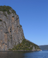
Cap Trinité -

Notre-Dame-du-Saguenay Statue -
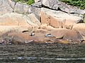
Harbor seals inside the park -
Baie Éternité


See also
- Sépaq
- Vallée-de-la-Rivière-Sainte-Marguerite Biodiversity Reserve
