Rivière aux Sables (Saguenay River tributary) facts for kids
Quick facts for kids Rivière aux Sables |
|
|---|---|

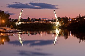
Aluminum walkway spanning the "rivière aux Sables" in Saguenay (city)
|
|
| Country | Canada |
| Province | Quebec |
| Region | Saguenay-Lac-Saint-Jean |
| Regional County Municipality | Le Fjord-du-Saguenay Regional County Municipality |
| City | Saguenay |
| Physical characteristics | |
| Main source | Kenogami Lake Saguenay 164 units? 48°19′36″N 71°22′36″E / 48.32667°N 71.37666°E |
| River mouth | Kenogami Lake Saguenay 67 m (220 ft) 48°26′34″N 71°14′49″E / 48.44278°N 71.24694°E |
| Length | 11 km (6.8 mi) |
| Basin features | |
| Tributaries |
|
The Rivière aux Sables is a cool river located in the city of Saguenay, in Quebec, Canada. This river is one of two places where water flows out of Kenogami Lake. It travels north until it joins the big Saguenay River. It's special because it's the only river that goes right through the town of Jonquière.
You can find streets like Saint-Jean-Baptiste and Saint-Dominique along its banks. Bigger roads like Boulevard du Royaume and Price Street are also nearby. The Autoroute 70 even crosses over the river in the middle.
During winter, the river usually freezes over from late November to early April. It's generally safe to walk or play on the ice from mid-December to the end of March.
Where the River Flows
The Rivière aux Sables starts at the Pibrac-Ouest dam on Kenogami Lake. This lake is about 26.9 kilometers (16.7 miles) long and sits at an elevation of 164 meters (538 feet).
The river's starting point is:
- About 7.3 kilometers (4.5 miles) northwest of the Portage-des-Roches dam.
- About 6.5 kilometers (4 miles) north of where the Cyriac River meets Kenogami Lake.
- About 8.6 kilometers (5.3 miles) south of downtown Kénogami.
- About 9.5 kilometers (5.9 miles) south of where the Rivière aux Sables joins the Saguenay River.
From its start, the Rivière aux Sables flows for about 10.1 kilometers (6.3 miles). It drops about 159 meters (522 feet) in height as it goes, mostly through city areas. Here's how it flows:
- It goes northwest for 1.7 kilometers (1.1 miles) to the bridge on Saint-Dominique street.
- Then, it flows north for 2.3 kilometers (1.4 miles), making big zigzags. It picks up the Desgagné stream and passes under the Autoroute 70 bridge.
- Next, it travels 3.7 kilometers (2.3 miles) north, collecting the Chasseurs stream. It goes under a railway bridge, past a dam, and under the Boulevard du Royaume bridge (Route 170).
- Finally, it flows 2.4 kilometers (1.5 miles) north, crossing another dam and going under the Chute-à-Caron street bridge, before reaching its end.
The Rivière aux Sables empties into the south side of the Saguenay River. This meeting point is:
- About 1.0 kilometer (0.6 miles) southeast of the Chute-à-Caron dam on the Saguenay River.
- About 1.6 kilometers (1 mile) northwest of downtown Kénogami.
- About 3.1 kilometers (1.9 miles) southeast of where the Shipshaw River meets the Saguenay River.
- About 13.3 kilometers (8.3 miles) southwest of downtown Chicoutimi (part of Saguenay city).
- About 28.9 kilometers (17.9 miles) west of the Baie des Ha! Ha!.
From where the Rivière aux Sables joins the Saguenay River, the water then flows for about 142.7 kilometers (88.7 miles) east to Tadoussac. There, it mixes with the huge Saint Lawrence estuary. The mouth of the Rivière aux Sables is about 14.5 kilometers (9 miles) upstream from where the Chicoutimi River joins the Saguenay.
Bridges You Can Cross
Many bridges go over the Rivière aux Sables, letting people and cars get from one side to the other. Here are some of them, listed from south to north:
- The Pibrac bridge on St-Dominique street, heading towards Lac-Kénogami.
- CEPAL walkways, which are just for people walking.
- The Autoroute 70 bridge.
- The aluminum walkway, another bridge just for pedestrians.
- An old bridge near the Rivière-aux-Sables park.
- The railway bridge, where trains cross.
- Harvey Boulevard Bridge.
- Nelson Bridge (Route 170).
- The old Price Bridge.
- The rue Chute bridge in Caron.
Fun Things to Do
In the Jonquière area, the Rivière aux Sables is calm and peaceful. This makes it a great spot for lots of activities! In the summer, you can go fishing or enjoy the water in a pedal boat or canoe.
A fun event called the "duck race" used to happen on the river. It was organized by the Jonquière hospital to raise money for a good cause. Thousands of little yellow rubber ducks were released into the river. They would float downstream, and the first one to reach the finish line would win a prize for its "owner." This event now takes place at the end of summer.
River's Name
The name "Rivière aux Sables" was officially recognized on December 5, 1968. This was done by the Place Names Bank of the Commission de toponymie du Québec, which is like a special group that names places in Quebec.
Related Places
- Kenogami Lake, a large body of water
- Saguenay River, a major river
- Kénogami (city)
- Saguenay (city)
- List of rivers of Quebec
 | Kyle Baker |
 | Joseph Yoakum |
 | Laura Wheeler Waring |
 | Henry Ossawa Tanner |


