Lake Nemiscau facts for kids
Quick facts for kids Lake Nemiscau |
|
|---|---|

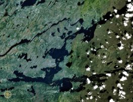
Satellite view of Nemiscau Lake
|
|
| Location | Baie-James, Jamésie Territory, Quebec |
| Coordinates | 51°25′40″N 76°43′12″W / 51.42778°N 76.72000°W |
| Primary inflows | Rupert River, Nemiscau River |
| Primary outflows | Rupert River |
| Basin countries | Canada |
Lake Nemiscau (called Lac Nemiscau in French) is a freshwater lake in Quebec, Canada. It's located in the large region of Nord-du-Québec, in the area known as Eeyou Istchee James Bay. The important Rupert River flows right through Lake Nemiscau.
On the north side of the lake, there's a place called Nemiscau. This used to be an abandoned settlement. However, in recent years, the Cree people have started using Nemiscau again as a summer home. The closest village to Lake Nemiscau is Nemaska, which is about 60 kilometres (37 mi) (37 miles) to the northeast.
Where is Lake Nemiscau?
Lake Nemiscau is a key part of the Rupert River system. The Rupert River flows into the lake from the south. Another river, the Nemiscau River, also feeds into the lake from the east. After passing through Lake Nemiscau, the Rupert River continues its journey.
The Name of the Lake
The name "Nemiscau" has been used for this lake for a very long time.
- An old map from 1685, called "Partie de la Nouvelle-France" (Part of New France), shows the lake as "Nimisco Lake".
- Another map from 1703, by Guillaume Delisle, calls it "Lake Nemisko".
- In 1715, a map titled "A New and Exact map of the Dominions of the King of great Britain on the continent of North America" used the spelling "Nemisco L.". This map was updated around 1732.
The official name, Lake Nemiscau, was formally recognized on December 2, 1982. This was done by the Commission de toponymie du Québec, which is the official board in Quebec that names places.
 | John T. Biggers |
 | Thomas Blackshear |
 | Mark Bradford |
 | Beverly Buchanan |


