Île d'Orléans, Louisiana facts for kids
Île d'Orléans (pronounced "Eel dor-lay-AHN"), which means "Isle of Orleans" in French, was the historic name for the area around New Orleans in what is now Louisiana, U.S.A.. It was a special piece of land with an interesting history, especially during a time when different European countries were trying to control parts of North America.
Contents
What Was the Isle of Orleans?
The Isle of Orleans was a specific area of land that included the important city of New Orleans. It was defined during a time when France and Great Britain were fighting over land in North America.
How It Became Spanish
In 1762, France was expecting to lose a big war called the French and Indian War (also known as the Seven Years' War in Europe). To prevent Great Britain from taking all of its land in Louisiana, France secretly gave a large part of it to Spain. This was done through a deal called the Treaty of Fontainebleau.
The Secret Deal
This secret deal transferred all of Louisiana west of the Mississippi River to Spain. It also included a newly defined area east of the Mississippi, which was named the Isle of Orleans. This special area included the city of New Orleans.
What Happened After the War?
As France had expected, Great Britain did take a lot of land after the war. In the Treaty of Paris (1763), Great Britain took all of Louisiana east of the Mississippi River. However, the Isle of Orleans was an exception.
British and Spanish Control
The British added their new land to their colony of West Florida, with its capital at Pensacola. The Treaty of Paris also officially confirmed that Spain owned Louisiana west of the Mississippi River and the Isle of Orleans. So, even though it was east of the river, the Isle of Orleans remained under Spanish control.
Where Was It Located?
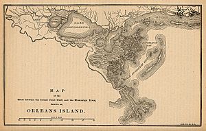
The Isle of Orleans was bordered by several natural features. It was surrounded by the Mississippi River and the Gulf of Mexico.
Natural Borders
Other borders included Lake Pontchartrain, Lake Maurepas, the Amite River, and a waterway called Bayou Manchac. Bayou Manchac was previously known as the Iberville River. These natural boundaries helped define this unique piece of land.
The Louisiana Purchase
The Isle of Orleans was an important part of the huge land deal known as the Louisiana Purchase in 1803. This is when the United States bought a massive amount of land from France.
A Short-Lived Republic
A few years later, the Isle of Orleans formed the southern border of a very short-lived country called the Republic of West Florida. This republic existed for only a brief time before becoming part of the United States.
 | John T. Biggers |
 | Thomas Blackshear |
 | Mark Bradford |
 | Beverly Buchanan |


