Lake Maurepas facts for kids
Quick facts for kids Lake Maurepas |
|
|---|---|
| Lac Maurepas | |

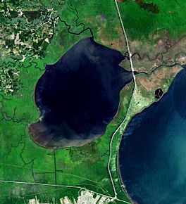
Landsat view of the lake bordered at right by Lake Pontchartrain
|
|
| Location | Louisiana: Livingston Parish St. John the Baptist Parish Tangipahoa Parish |
| Coordinates | 30°15′29″N 90°29′55″W / 30.258029°N 90.498676°W |
| Type | it is a round-shaped, shallow, Brackish water tidal estuarine system |
| Basin countries | United States |
| Surface area | 240 km2 (93 sq mi) |
| Average depth | 3.0 m (9.8 ft) |
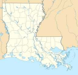
Lake Maurepas is a large lake in southeastern Louisiana. It's located about halfway between the cities of New Orleans and Baton Rouge. You can find it directly west of Lake Pontchartrain, another well-known lake in the area.
Contents
How Lake Maurepas Got Its Name
Lake Maurepas was named after a French statesman (a very important government official) named Jean-Frédéric Phélypeaux. He was a chief advisor to King Louis XVI of France in the 1700s.
Interestingly, Jean-Frédéric's father, Louis Phélypeaux, was the person for whom Lake Pontchartrain is named. So, two nearby lakes in Louisiana are named after a father and son from France!
What Makes Lake Maurepas Special?
Lake Maurepas is shaped like a circle and isn't very deep. It's a "brackish" water system, which means its water is a mix of fresh water and salt water. This type of system is called an "estuary." The lake covers an area of about 240 square kilometers (about 93 square miles). Its average depth is around 3.0 meters (about 10 feet).
Water Flow and Connections
Fresh water flows into Lake Maurepas from four main rivers: the Blind River, Amite River, Tickfaw River, and the Natalbany River. These rivers and other small land sources bring fresh water into the lake.
On its northeast side, Lake Maurepas connects to Lake Pontchartrain through a channel called Pass Manchac. This pass is made up of two smaller channels, South Pass and North Pass, which meet on the eastern side of Jones Island. The amount of water that moves between Lake Maurepas and Lake Pontchartrain through Pass Manchac is a big influence on Lake Maurepas.
The Manchac Swamp Bridge, which carries Interstate 55, crosses this area between the two lakes.
Tides and Salinity
The normal tide changes in Lake Maurepas are small, about 0.15 meters (0.5 feet). However, strong winds can cause bigger tide changes in both Lake Pontchartrain and Lake Maurepas. This leads to interesting patterns of water exchange and mixing in the lake over weeks and even fortnights (two-week periods).
The amount of salt in Lake Maurepas, called "salinity," changes depending on how much water exchanges with Lake Pontchartrain. The salinity in Lake Maurepas has been measured from almost no salt to about 3 parts per thousand. Usually, the water is saltier along the eastern shore, closer to Pass Manchac.
Water Clarity
Because Lake Maurepas is shallow, even small waves can stir up the sediment (dirt and sand) from the bottom. This makes the water cloudy, which is called "turbidity." High turbidity means the water isn't very clear. This can affect how much "primary production" (like plant growth) can happen in the water and on the lake bottom.
Maurepas Swamp Wildlife Management Area
The Maurepas Swamp Wildlife Management Area (WMA) is a special protected area located about 25 miles northwest of New Orleans. It's found along the south shore and south of Lake Maurepas. This area stretches from LaPlace towards Sorrento.
The Richard King Mellon Foundation first donated a large piece of land, about 61,633 acres, to the Louisiana Department of Wildlife and Fisheries (LDWF) for this WMA. Later, more land was bought or donated, bringing the total size to 122,098 acres.
The swamp in this area would benefit from projects that bring fresh water back into it. These projects are designed to help the swamp become healthy again. Also, controlling "invasive plant species" (plants that are not native and can take over) is important. These plants have grown too much in parts of this beautiful and important swamp.
See also
 In Spanish: Lago Maurepas para niños
 | Ernest Everett Just |
 | Mary Jackson |
 | Emmett Chappelle |
 | Marie Maynard Daly |


