
LaPlace, Louisiana facts for kids
Quick facts for kids
LaPlace, Louisiana
|
|
|---|---|

U.S. Highway 61 (Airline Highway) at U.S. Highway 51 intersection in LaPlace
|
|

LaPlace, Louisiana
Location in Louisiana
|
|
| Country | United States |
| State | Louisiana |
| Parish | St. John the Baptist |
| Area | |
| • Total | 22.05 sq mi (57.11 km2) |
| • Land | 20.89 sq mi (54.12 km2) |
| • Water | 1.16 sq mi (2.99 km2) |
| Elevation | 10 ft (3 m) |
| Population
(2020)
|
|
| • Total | 28,841 |
| • Density | 1,380.28/sq mi (532.92/km2) |
| Time zone | UTC-6 (CST) |
| • Summer (DST) | UTC-5 (CDT) |
| ZIP code |
70068
|
| Area code(s) | 985 |
| FIPS code | 22-42030 |
LaPlace (/ləˈplɑːs/ LƏ-plahss) is a community in St. John the Baptist Parish, Louisiana. It is located along the east bank of the Mississippi River. LaPlace is part of the New Orleans metropolitan area. In 2020, about 28,841 people lived there.
LaPlace is an important meeting point for major highways. Interstate 55 and US 51 both end here, connecting with Interstate 10 and US 61. The town is about 25 miles (40 km) west of New Orleans.
Contents
History of LaPlace
Early Inhabitants
The Chitimacha people lived in this area before Europeans arrived. Their lands once covered a huge region, from the Atchafalaya Basin to the Gulf of Mexico. Today, the Chitimacha tribe lives on a reservation in St. Mary Parish.
European Settlement

In the early 1700s, German immigrants settled what is now LaPlace. This was during the time when France controlled Louisiana. Their settlement was called Karlstein. It was part of a larger area known as the "German Coast" (la Côte des Allemands). This name came from the many German-speaking people who moved there starting in 1721.
Over time, French and Acadians (French-speaking people from Canada) married the German settlers. The area then became known as Bonnet Carré. This French name means "square bonnet." It was inspired by a sharp, right-angle turn in the Mississippi River nearby, which looked like a square bonnet.
The 1811 Slave Revolt
In 1793, a plantation called Woodland was built by Manual Andry. Enslaved people were forced to work there, growing sugarcane. They faced very harsh conditions.

In January 1811, enslaved people from Woodland and nearby plantations started the 1811 German Coast Uprising. A large group, possibly 200 to 500 people, armed themselves. They marched from LaPlace, hoping to reach and take over New Orleans to gain their freedom.
However, local white groups quickly stopped the rebellion within three days. Many enslaved people were killed during the fighting or hunted down afterward. Others were executed after quick trials. This event is considered one of the largest slave rebellions in U.S. history.
How LaPlace Got Its Name
After the American Civil War, in 1879, a man named Basile Laplace moved to Bonnet Carré from New Orleans. He was a pharmacist and also owned a large plantation.
In 1883, he allowed a new railroad to build tracks across his land. The railroad station built there was named after him. Soon, the local post office and then the entire town became known as LaPlace.
In the 1920s, the Montegut family bought Woodland Plantation. A famous musician, Kid Ory, was born in an outbuilding on this plantation. He later became a successful jazz band leader in New Orleans.
Major Weather Events
LaPlace has experienced several serious weather events.
- Between 1850 and 1883, the levee (a protective wall) on the Mississippi River's east bank flooded many times.
- In 1850, a flood caused a huge break in the levee called the Bonnet Carré Crevasse. This break was over a mile wide and led to severe flooding in New Orleans in 1871. The levee break was finally closed in 1883.
- In 1983, a powerful F4 tornado caused a lot of damage in parts of the town.
- In 1992, Hurricane Andrew brought an F3 tornado that killed two people.
- In 2012, Hurricane Isaac caused flooding that damaged about 5,000 homes in LaPlace.
- In 2016, several tornadoes hit LaPlace, damaging many buildings and causing power outages.
- On August 29, 2021, Hurricane Ida also caused significant damage to the town.
The Spelling of LaPlace
Even though the town is named after Basile Laplace, the local government decided in 1971 that the official spelling of the town should have a capital "P" in "LaPlace."
Andouille Sausage Capital

Andouille is a type of smoked pork sausage that came from France. It is very popular in LaPlace and throughout Louisiana. In the 1970s, the governor of Louisiana, Edwin Edwards, declared LaPlace the "Official Andouille Capital of the World."
Since 1972, LaPlace has hosted an Andouille Festival every October. This festival celebrates the famous sausage. TV chef Alton Brown even visited LaPlace for his show Feasting on Asphalt to try its andouille.
Local Economy
The main office for the Port of South Louisiana is located in LaPlace. This port is one of the largest in the world by cargo volume. Other big companies that employ many people in the area include Shell Chemical Company, DuPont, ADM Growmark, and ArcelorMittal.
Geography
LaPlace is located at 30°4′30″N 90°29′6″W / 30.07500°N 90.48500°W. It is about 10 feet (3 meters) above sea level.
The community covers a total area of about 22.7 square miles (58.8 km²). Most of this area, about 21.5 square miles (55.7 km²), is land. The remaining 1.2 square miles (3.1 km²) is water.
Population Information
| Historical population | |||
|---|---|---|---|
| Census | Pop. | %± | |
| 2000 | 27,684 | — | |
| 2010 | 29,872 | 7.9% | |
| 2020 | 28,841 | −3.5% | |
| U.S. Decennial Census | |||
In 2020, LaPlace had a population of 28,841 people. The community is diverse, with people from many different backgrounds living there.
In 2019, the average income for a household in LaPlace was about $53,253. The median age of people living in LaPlace was 36.3 years old.
Education
Public Schools
The St. John the Baptist Parish School Board manages the public schools in LaPlace.
- Lake Pontchartrain Elementary School (grades K-8)
- Laplace Elementary School
- John L. Ory Communications Magnet Elementary School
- Emily C. Watkins Elementary School
- St. John Special Education
Some schools with a LaPlace postal address are actually in other nearby areas:
- East St. John Preparatory Academy (grades 5-8) is in Reserve CDP.
- East St. John High School is also in Reserve CDP.
- St. John STEM Magnet Program is in Reserve.
Private Schools
LaPlace also has several private schools, including Catholic schools:
- Ascension of Our Lord School (Catholic)
- St. Joan of Arc Catholic School (Catholic)
- Saint Charles Catholic High School (Catholic)
Other private Christian schools in the nearby Reserve CDP include:
- Liberty Christian Academy
- Riverside Academy
LaPlace in Movies and TV
LaPlace has been a filming location for several movies and TV shows:
- The Academy Award-winning movie Monster's Ball, starring Halle Berry.
- The television series Memphis Beat.
- Scenes from the WWE Studios movie Knucklehead.
- The Old Airline Motors Diner in LaPlace was used as an IHOP in the movie Glory Road.
- The Jonas Brothers music video "Pom Poms" was filmed at Joe Keller Memorial Stadium in nearby Reserve, Louisiana.
Famous People From LaPlace
- Jared Butler, a basketball player for Baylor University.
- A. J. Duhe, a former linebacker for the Miami Dolphins.
- Randal Gaines, a Louisiana State Representative.
- Louis Lipps, a former wide receiver for the Pittsburgh Steelers and New Orleans Saints.
- Edward "Kid" Ory, a famous trombonist and bandleader.
Images for kids
-
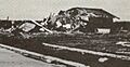
F4 tornado damage to a home in LaPlace in 1983.

See also
 In Spanish: Laplace (Luisiana) para niños
