
New Orleans metropolitan area facts for kids
Quick facts for kids
New Orleans
|
|
|---|---|
| New Orleans–Metairie | |
|
From top: New Orleans, Kenner, Metairie, showcasing Downtown New Orleans, Kenner Old Rivertown, and Metairie Central Business District
|
|

Location of the New Orleans–Metairie–Slidell CSA and its components:
New Orleans–Metairie MSA Slidell–Mandeville–Covington, MSA Bogalusa μSA Picayune μSA Louisiana Mississippi |
|
| Country | United States |
| State(s) | Louisiana |
| Largest city | New Orleans |
| Other cities | • Kenner • Gretna |
| Area | |
| • Total | 3,755.2 sq mi (9,726 km2) |
| Highest elevation | 371 ft (113 m) |
| Lowest elevation | -7 ft (-2 m) |
| Population
(2020)
|
|
| • Total | 1,270,530 |
| • Rank | 45th |
| • Density | 311/sq mi (120/km2) |
| GDP | |
| • MSA | $94.031 billion (2022) |
| Time zone | UTC-6 (CST) |
| • Summer (DST) | UTC-5 (CDT) |
| Area code(s) | 504, 985 |


The New Orleans metropolitan area, also known as Greater New Orleans, is a large urban region in Louisiana, USA. It includes the famous city of New Orleans and several surrounding areas. This region is officially called the New Orleans–Metairie metropolitan statistical area.
It is made up of seven special areas called parishes, which are like counties in other states. In 2020, about 1.27 million people lived in Greater New Orleans. This makes it the most populated metropolitan area in Louisiana. It is also the 45th most populated in the entire United States.
In 2005, Hurricane Katrina caused a lot of damage to the New Orleans area. The storm was a Category 3 hurricane when it hit. Many levees and flood walls broke, causing widespread flooding. The city of New Orleans lost many residents after the hurricane. However, by 2020, a good number of people had moved back.
Greater New Orleans has the biggest economy in Louisiana. It is also close to the second largest economic area, Greater Baton Rouge. Many large companies operate here, including Entergy, Globalstar, AT&T, and GE Capital. The Port of New Orleans is also a very important part of the economy. Tourists love to visit this area, spending over $10 billion in 2019.
Contents
- Discovering the Geography of New Orleans
- Main Cities and Towns in Greater New Orleans
- Understanding the Population of New Orleans
- The Larger New Orleans Combined Statistical Area
- The Economy of Greater New Orleans
- Sports Teams in New Orleans
- Getting Around: Transportation in New Orleans
- Protecting New Orleans from Floods
- Images for kids
- See also
Discovering the Geography of New Orleans
For official purposes, the New Orleans–Metairie metropolitan area includes seven parishes. These are Jefferson, Orleans (which is the city of New Orleans itself), Plaquemines, St. Bernard, St. Charles, St. James, and St. John the Baptist.
Some other parishes, like St. Tammany, Tangipahoa, and Washington, are often considered part of the region. They are located across Lake Ponchartrain from New Orleans.
The New Orleans region has a large workforce of over 650,000 people. More than 65,000 students attend the nine universities and eight colleges in the area. Most of the land in the New Orleans metropolitan area is very low, close to sea level. However, closer to the Mississippi border, the land rises to about 371 feet (113 meters) above sea level.
Main Cities and Towns in Greater New Orleans
The Heart of the Region: New Orleans
- New Orleans is the main and largest city in the metropolitan area.
Big Cities with Over 50,000 People
Towns with 10,000 to 50,000 Residents
Smaller Communities with Fewer Than 10,000 People
Understanding the Population of New Orleans
| Historical populations - Greater New Orleans | |||
|---|---|---|---|
| Census | Pop. | %± | |
| 1950 | 685,405 | — | |
| 1960 | 868,480 | 26.7% | |
| 1970 | 1,045,809 | 20.4% | |
| 1980 | 1,187,073 | 13.5% | |
| 1990 | 1,238,816 | 4.4% | |
| 2000 | 1,337,726 | 8.0% | |
| 2010 | 1,189,166 | −11.1% | |
| 2020 | 1,271,845 | 7.0% | |
| U.S. Decennial Census2017 estimate | |||
The New Orleans metropolitan area was first defined in 1950. Back then, it included three parishes: Orleans, Jefferson, and St. Bernard. Its population was about 685,405 people. By 1960, the population had grown to 868,480.
Over the years, more parishes were added to the metropolitan area. In 1963, St. Tammany Parish joined. By 1983, St. Charles and St. John the Baptist parishes were included. In 1993, Plaquemines and St. James parishes also became part of the area.
In 2010, the population of the metropolitan area was 1,189,166. The population is diverse, with many different racial and ethnic groups. In 2020, the population grew to 1,271,845. There were about 485,267 households, with an average of 2.6 people per home.
Most people in Greater New Orleans speak English. Spanish is the next most common language. The average age of people living here is 39. About 8% of the population was born in other countries, mostly from Latin America and Asia.
The Larger New Orleans Combined Statistical Area
The New Orleans–Metairie–Slidell combined statistical area (CSA) is an even larger region. It includes nine parishes in Louisiana and one county in Mississippi. This bigger area combines two larger metropolitan areas and two smaller micropolitan areas.
Parts of the Combined Statistical Area
- Metropolitan statistical areas (MSAs)
- New Orleans–Metairie MSA: This includes Jefferson, Orleans, Plaquemines, St. Bernard, St. Charles, St. James, and St. John the Baptist parishes.
- Slidell–Mandeville–Covington MSA: This area includes St. Tammany Parish.
- Micropolitan statistical areas (μSAs)
In 2022, the combined statistical area had an estimated population of 1,485,510 people. The population is very diverse, with many different backgrounds.
The Economy of Greater New Orleans

Greater New Orleans is home to one of the busiest ports in the world. The Port of New Orleans and the nearby Port of South Louisiana handle a huge amount of goods. This makes them very important for trade.
One of the biggest companies based here is Entergy. Other major companies include Globalstar, Textron, and Intralox. Many other large businesses, like DXC Technology, Folgers, AT&T, and GE Capital, also have big operations in the area.
The region is a major center for oil and gas production. About 88% of the nation's oil rigs off the coast are in this area. New Orleans also has growing industries in film, technology, and healthcare. For example, a new University Medical Center and a Veterans Affairs Medical Center were built recently.
The Louis Armstrong New Orleans International Airport is a busy airport. It connects to many cities across the U.S. and some international destinations. These strong industries and transportation links help the economy grow.
Sports Teams in New Orleans
New Orleans is home to several professional sports teams. Fans love to cheer them on!
| Club | Sport | League | Venue (capacity) | Founded | Titles | Record attendance |
|---|---|---|---|---|---|---|
| New Orleans Saints | American football | NFL | Caesars Superdome (73,208) | 1967 | 1 | 73,373 |
| New Orleans Pelicans | Basketball | NBA | Smoothie King Center (16,867) | 2002 | 0 | 18,444 |
| New Orleans Jesters | Soccer | NPSL | Pan American Stadium (5,000) | 2003 | 0 | 5,000 |
| New Orleans Gold | Rugby union | MLR | Gold Mine (10,000) | 2017 | 0 | 1,900 |
Getting Around: Transportation in New Orleans

The main airport for the area is Louis Armstrong New Orleans International Airport. It is located in the city of Kenner, west of downtown New Orleans. Many airlines fly from this airport to cities all over the U.S. and to some international places like London and Toronto.
Major highways like Interstate 10, Interstate 12, and Interstate 55 connect the New Orleans area. The Lake Pontchartrain Causeway is a very long bridge, about 24 miles (39 km) long. It connects Metairie on the south shore to Mandeville on the North Shore. It is the world's longest bridge over water!
If a big hurricane threatens the area, the Louisiana State Police can use a special plan. They can reverse traffic lanes on highways to help people evacuate faster. This is called a contraflow lane reversal program.
The New Orleans area is also served by major freight railroads. Passenger train service is available through Amtrak on routes like the Crescent and City of New Orleans.
Protecting New Orleans from Floods

The U.S. Army Corps of Engineers is in charge of designing and building the flood protection system for Greater New Orleans. This system helps protect the area from floods. In 2007, Louisiana voters created a new group called the Southeast Louisiana Flood Protection Authority. This group works with the Corps of Engineers on flood protection.
One important part of the flood control system is the Bonnet Carré Spillway. This structure helps control the water levels of the Mississippi River.
Images for kids
-
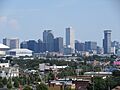
Downtown New Orleans
-
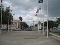
Kenner Old Rivertown
-

Metairie Central Business District
-
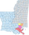
Map of Greater New Orleans
-

University Medical Center New Orleans
-

Delta SkyClub at Louis Armstrong New Orleans International Airport
-
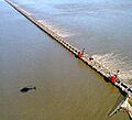
Opening of the Bonnet Carré Spillway on 1997-03-17. The spillway was operational from March 17 to April 18, 1997 – operating at a maximum flow of 243,000 cubic feet per second.
See also
 In Spanish: Área metropolitana de Nueva Orleans para niños
