Lake Pontchartrain Causeway facts for kids
Quick facts for kids Lake Pontchartrain Causeway |
|
|---|---|
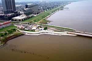
The southern end of the causeway at Metairie, Louisiana, in 1998
|
|
| Carries | 4 lanes of Causeway Blvd. |
| Crosses | Lake Pontchartrain |
| Locale | Metairie and Mandeville, Louisiana, U.S. |
| Maintained by | Causeway Commission |
| Characteristics | |
| Design | Low-level trestle with mid-span bascule |
| Total length | 23.8755555 mi (38.442 km) |
| Clearance above | 15 ft |
| History | |
| Opened | August 30, 1956 (southbound) May 10, 1969 (northbound) |
| Statistics | |
| Daily traffic | 43,000 |
| Toll | $5.00 (southbound) |
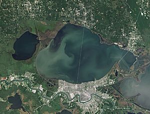
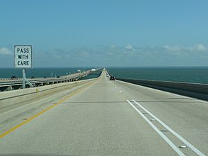
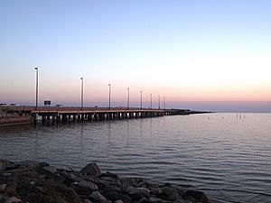
The Lake Pontchartrain Causeway, often called The Causeway, is a very long bridge in Louisiana, United States. It is made of two parallel bridges that cross Lake Pontchartrain. The longer of these two bridges stretches about 38.35 kilometers (23.83 miles).
The southern end of the causeway is in Metairie, Louisiana. This is a town near New Orleans. The northern end is in Mandeville, Louisiana.
For many years, starting in 1969, the Causeway was listed by Guinness World Records as the longest bridge over water in the world. In 2011, after a longer bridge opened in China, Guinness World Records created two new categories. The Lake Pontchartrain Causeway then became the longest continuous bridge over water.
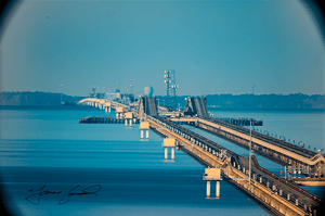
The bridges stand on 9,500 concrete poles. They also have a special section called a bascule. This part can open up to let boats pass through. It is located about 8 kilometers (5 miles) south of the north shore. About 12 million vehicles drive across this bridge every year.
Contents
Building the Causeway: A Look at Its History
The idea for a bridge over Lake Pontchartrain is very old. It goes back to the early 1800s. A man named Bernard de Marigny, who founded Mandeville, first thought of it. He even started a ferry service across the lake. This ferry ran until the mid-1930s.
In the 1920s, there was a plan to build artificial islands in the lake. These islands would then be connected by bridges. The money for this plan would come from selling homes on the islands.
The modern idea for the Causeway began in 1948. Ernest M. Loeb Jr. imagined the project. Because of his hard work, the Louisiana Legislature created the Causeway Commission. A company called the Louisiana Bridge Company was formed to build the bridge. James E. Walters Sr. was chosen to lead this big project.
The first Causeway was a two-lane bridge. It was about 38.39 kilometers (23.86 miles) long. It opened in 1956 and cost $46 million. This price included the bridge itself and the roads leading to it.
In 1964, an unfortunate accident happened. Barges hit the bridge, causing a section to break. A bus then went into the lake.
A second, parallel bridge was built next to the first one. It was just a little bit longer. This new two-lane bridge opened on May 10, 1969. It cost $30 million to build.
Paying to Cross: Tolls and Traffic
Since it was built, the Causeway has been a toll bridge. This means drivers pay a fee to cross it. Until 1999, tolls were collected from cars going in both directions. To help with traffic jams on the south side, tolls for northbound traffic were stopped.
In May 1999, the toll for cars changed. Instead of paying $1.50 in each direction, drivers paid a $3 toll only when going southbound. In 2017, the toll was raised again. This was to help pay for safety improvements on the bridge. The cash toll became $5.00, and if you used a special toll tag, it was $3.00.
Connecting Communities: The Causeway's Impact
The opening of the Causeway greatly helped the small towns on the North Shore. It cut down the driving time to New Orleans by as much as 50 minutes. This made the North Shore part of the New Orleans metropolitan area.
Before the Causeway, people from St. Tammany Parish had to use other bridges. These included the Maestri Bridge or the Rigolets Bridge near Slidell, Louisiana. Or they would drive west through Manchac, Louisiana.
Surviving Storms: The Causeway and Hurricanes
After Hurricane Katrina hit on August 29, 2005, there was some damage to the bridge. However, the storm surge (the rise in water level) was not as high under the Causeway as it was near the I-10 Twin Span Bridge. Most of the damage was to the turnaround sections. About 17 sections of the bridge were lost. But the main foundations of the bridge stayed strong.
The Causeway has been very strong against hurricanes and other natural events. This is quite rare for such a long bridge. The fiber optic cables on the bridge were blown out of their trays but remained working.
Because the nearby I-10 Twin Span Bridge was badly damaged, the Causeway became a very important route. It helped recovery teams get into New Orleans from the north. The Causeway reopened for emergency traffic first. Then it opened to the public on September 19, 2005, with no tolls for a while. Tolls were put back in place by mid-October that year.
Other Long Bridges in Louisiana
The Lake Pontchartrain Causeway is one of seven highway bridges in Louisiana that are 8 kilometers (5 miles) or longer. The others are:
- The Manchac Swamp bridge on I-55
- The Atchafalaya Basin Bridge on I-10
- The Louisiana Highway 1 Bridge
- The Bonnet Carré Spillway Bridge on I-10
- The Chacahoula Swamp Bridge on U.S. 90
- The Lake Pontchartrain Twin Spans on I-10
- The LaBranche Wetlands Bridge on I-310
The Maestri Bridge is almost 8 kilometers long, but it is a bit shorter. Louisiana also has the Norfolk Southern Lake Pontchartrain Bridge. This is a railway bridge that is about 9.3 kilometers (5.8 miles) long. It is one of the longest railway bridges in the United States.
Some of these bridges are actually connected. For example, the southern end of the Manchac Swamp Bridge connects to the western end of the I-10 Bonnet Carré Spillway Bridge. And the northern end of the LaBranche Wetlands Bridge is the eastern end of the I-10 Bonnet Carré Spillway Bridge. This means these three bridges are actually one very long, continuous elevated road. The total driving distance on this continuous elevated roadway is over 61 kilometers (38 miles).
In 2013, the Lake Pontchartrain Causeway was named a National Historic Civil Engineering Landmark. This was done by the American Society of Civil Engineers.
See also
 In Spanish: Calzada del lago Pontchartrain para niños
 | Roy Wilkins |
 | John Lewis |
 | Linda Carol Brown |


