
Metairie, Louisiana facts for kids
Quick facts for kids
Metairie
|
||
|---|---|---|

Metairie Central Business District along Causeway Blvd
|
||
|
||

Metairie
Location in Louisiana

Metairie
Location in the United States
|
||
| Country | ||
| State | ||
| Parish | Jefferson | |
| Area | ||
| • Total | 23.30 sq mi (60.35 km2) | |
| • Land | 23.26 sq mi (60.24 km2) | |
| • Water | 0.04 sq mi (0.11 km2) | |
| Elevation | 3 ft (0.9 m) | |
| Population
(2020)
|
||
| • Total | 143,507 | |
| • Density | 6,169.96/sq mi (2,382.27/km2) | |
| Time zone | UTC−6 (CST) | |
| • Summer (DST) | UTC−5 (CDT) | |
| ZIP Codes |
70001–70006, 70009–70011, 70033, 70055, 70060
|
|
| Area code(s) | 504 | |
| GNIS feature ID | 555301 | |

Metairie (pronounced MET-ər-ee) is a large community in Jefferson Parish, Louisiana, United States. It is part of the New Orleans metropolitan area. In 2020, Metairie had a population of 143,507 people. This makes it the biggest community in Jefferson Parish. If it were a city, it would be Louisiana's fourth-largest.
Contents
What's in a Name?
The name Métairie comes from a French word. It means a small farm where the farmer paid the owner with a share of the crops. This practice is called sharecropping. Many early French farmers in the 1760s were tenant farmers. After the American Civil War, most people in Metairie were sharecroppers. The area started to become more urban in the 1910s.
A Look Back in Time
In the 1720s, French settlers were the first Europeans to live in Metairie. They settled on Metairie Ridge, a natural raised area. This ridge was formed by an old branch of the Mississippi River. Native Americans, like the Acolapissa, used this ridge as a road. It is the oldest road in the New Orleans area. Today, it is called Metairie Road.
An electric streetcar line was built along Metairie Road in the late 1910s. This helped the area grow a lot. Fancy houses were built nearby in the 1920s. This part is now known as "Old Metairie." The areas north and northwest of Metairie Road developed after World War II. The land between Metairie Ridge and Lake Pontchartrain used to be swamps. These areas were drained using a special pump. Because land was cheaper and taxes were lower, many people moved to Metairie. Its population grew quickly in the 1940s.
Hurricanes and Growth
Metairie has faced several strong storms. In 1947, a hurricane with very strong winds hit Metairie directly. Much of the community was under 6 feet of water. Hurricane Betsy hit in 1965, causing a lot of wind damage and some flooding. In 1995, a huge flood happened when 20 inches of rain fell in just twelve hours. This flooded parts of Metairie and nearby towns.
On August 29, 2005, Hurricane Katrina caused many people to move to Metairie. Their homes in New Orleans were destroyed by flooding. This led to Metairie becoming more diverse.
Modern Metairie
Today, Veterans Boulevard is a major shopping area. It was built next to a drainage canal. The main business area of Metairie is on Causeway Boulevard. Metairie also has Lakeside Shopping Center, one of the busiest malls in the New Orleans area. In the 1970s and 1980s, an area called "Fat City" became popular for its bars and nightclubs. Now, it's a very diverse area with many different restaurants. Metairie also has a big Mardi Gras celebration. Many people think it's more family-friendly than the one in New Orleans.
Where is Metairie?
Metairie is in eastern Jefferson Parish, Louisiana. It is next to New Orleans on the east and Kenner on the west. Lake Pontchartrain is to the north. The 17th Street Canal forms the border between Metairie and New Orleans. Metairie covers about 23.3 square miles (60.2 square kilometers) of land.
Metairie's Weather
Metairie has a humid subtropical climate. This means it has short, mild winters and hot, humid summers. On average, it gets about 62.5 inches of rain each year. The summer months are the wettest. It rarely gets very cold or extremely hot.
| Climate data for Metairie, Louisiana | |||||||||||||
|---|---|---|---|---|---|---|---|---|---|---|---|---|---|
| Month | Jan | Feb | Mar | Apr | May | Jun | Jul | Aug | Sep | Oct | Nov | Dec | Year |
| Record high °F (°C) | 82 (28) |
85 (29) |
88 (31) |
93 (34) |
96 (36) |
99 (37) |
101 (38) |
103 (39) |
101 (38) |
97 (36) |
87 (31) |
84 (29) |
103 (39) |
| Mean daily maximum °F (°C) | 63 (17) |
66 (19) |
73 (23) |
79 (26) |
85 (29) |
90 (32) |
92 (33) |
92 (33) |
88 (31) |
81 (27) |
72 (22) |
65 (18) |
79 (26) |
| Mean daily minimum °F (°C) | 45 (7) |
48 (9) |
55 (13) |
60 (16) |
68 (20) |
73 (23) |
75 (24) |
75 (24) |
72 (22) |
62 (17) |
54 (12) |
48 (9) |
61 (16) |
| Record low °F (°C) | 16 (−9) |
20 (−7) |
28 (−2) |
37 (3) |
51 (11) |
54 (12) |
64 (18) |
64 (18) |
— | — | — | — | 16 (−9) |
Tallest Buildings

Metairie has several tall buildings. The tallest is Three Lakeway Center. It stands at 403 feet (123 meters) tall.
| Rank | Name | Height ft (m) |
Floors | Year | Notes |
|---|---|---|---|---|---|
| 1 | Three Lakeway Center | 403 (123) | 34 | 1987 | Tallest building in Louisiana outside of New Orleans and Baton Rouge. |
| 2 | The Galleria | 269 (82) | 21 | 1986 | |
| 3 | Two Lakeway Center | 259 (79) | 19 | 1983 | |
| 4 | Heritage Plaza | 245 (75) | 18 | 1983 | |
| 5 | Executive Tower One | 204 (62) | 14 | 1972 | |
| 6 | One Lakeway Center | 193 (59) | 14 | 1982 |
People of Metairie
| Historical population | |||
|---|---|---|---|
| Census | Pop. | %± | |
| 1970 | 136,477 | — | |
| 1980 | 164,160 | 20.3% | |
| 1990 | 149,428 | −9.0% | |
| 2000 | 146,136 | −2.2% | |
| 2010 | 138,481 | −5.2% | |
| 2020 | 143,507 | 3.6% | |
| source:[1] | |||
In 2020, Metairie had a population of 143,507 people. The community has become more diverse over the years. In 2000, most residents were non-Hispanic white. By 2020, the number of people from various backgrounds, including Hispanic or Latino, Black, and Asian, had grown significantly.
Most households in Metairie have about 2 to 3 people. Many are married couples. The median income for a household was about $60,404 in 2019.
Religions in Metairie
About half of Metairie's residents identify with a religion. Because of its French and Spanish history, many people are Catholic. There are also many Baptist, Pentecostal, and other Christian groups. Metairie also has communities of Muslims, people who follow Eastern religions like Hinduism and Buddhism, and Jewish people. It is home to two synagogues, including Congregation Beth Israel, which is the oldest Orthodox Jewish group in the New Orleans area.
What Metairie Makes
Metairie is home to the headquarters of Rawbar Inc. This company runs Acme Oyster House, a popular restaurant chain.
Fun and Culture
Public Libraries


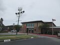
The Jefferson Parish Library system has several libraries in Metairie. The main library, the East Bank Regional Library, is located here. Other libraries include the Lakeshore Library, the Old Metairie Library, and the Wagner Library.
Sports in Metairie

Metairie used to be home to the New Orleans Baby Cakes baseball team. They played at Shrine on Airline from 1997 to 2019.
The training centers for the NFL team New Orleans Saints and the NBA team New Orleans Pelicans are in Metairie. This means many professional athletes live in the area. The New Orleans Gold rugby team also plays its home games in Metairie.
Parks and Play

Jefferson Parish has many parks in Metairie. These parks often have sports leagues for kids, like football, baseball, and basketball. Some also offer programs like piano lessons.
Here are some of the parks in Metairie:
- Cleary Playground
- Delta Playground
- Doe Playground
- Girard Playground
- Jim O'Ryan Playground
- Johnny Bright Playground
- Lafreniere Park
- Lakeshore Playground
- LaSalle Park
- Mike Miley Playground
- Pontiff Playground
Learning in Metairie
Public schools in Metairie are run by the Jefferson Parish Public School System.
The main public high school in Metairie is East Jefferson High School. Some students also go to Alfred Bonnabel High School in Kenner or Riverdale High School in Jefferson.
Metairie also has a special public school called Haynes Academy for Advanced Studies.
There are many private schools in Metairie, such as:
- Archbishop Chapelle High School
- Archbishop Rummel High School
- Crescent City Christian School
- Ecole Classique
- Lutheran High School
- Metairie Park Country Day School
- Ridgewood Preparatory School
- St. Martin's Episcopal School
Getting Around Metairie
Transportation

Most people in Metairie get around by car. There is a public bus system called "JeT" (Jefferson Transit). However, it does not run on Sundays, holidays, or late at night.
Interstate 10 is a major highway that goes through Metairie.
Important roads that run east-west include West Esplanade Avenue, Veterans Memorial Boulevard, Metairie Road, and Airline Drive. Many of these roads have large drainage canals in the middle. These canals are a unique feature of Metairie.

The Lake Pontchartrain Causeway, a very long bridge, starts in Metairie.
Images for kids
-
Another photo of the Eastbank Regional Library
-
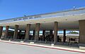
Grace King Senior High School (now closed)
-
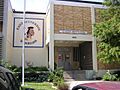
East Jefferson High School
-
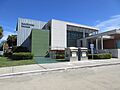
Lakeshore Library


See also
 In Spanish: Metairie para niños
