
Hurricane Katrina facts for kids

Katrina at peak intensity in the Gulf of Mexico on August 28
|
|
| Meteorological history | |
|---|---|
| Formed | August 23, 2005 |
| Extratropical | August 30, 2005 |
| Dissipated | August 31, 2005 |
| Category 5 tropical cyclone | |
| 1-minute sustained (SSHWS/NWS) | |
| Highest winds | 175 mph (280 km/h) |
| Lowest pressure | 902 mbar (hPa); 26.64 inHg |
| Overall effects | |
| Fatalities | 1,392 |
| Missing | 652 |
| Damage | $125 billion (2005 USD) (Costliest tropical cyclone on record when adjusted for inflation) |
| Areas affected |
|
|
Part of the 2005 Atlantic hurricane season |
|
| Hurricane Katrina |
|
 |
|
|
General Other wikis |
|
Hurricane Katrina was an extremely powerful and destructive tropical cyclone that struck the Southeastern United States in late August 2005. The massive storm caused catastrophic damage, especially in the historic city of New Orleans and along the coast of Mississippi. With damage costs reaching $125 billion, Katrina became the costliest tropical cyclone in United States history. Katrina was also one of the deadliest storms to hit the country, taking the lives of 1,392 people. It was the eleventh-named storm, the fifth hurricane, and the second Category 5 hurricane of the record-breaking 2005 Atlantic hurricane season.
The storm began on August 23 near the Bahamas when a tropical wave merged with an older weather system. After crossing southern Florida as a Category 1 storm, it entered the warm waters of the Gulf of Mexico. There, Katrina underwent rapid intensification, quickly growing into an enormous major hurricane. Its sustained winds reached a ferocious 175 miles per hour, and its barometric pressure dropped to historic lows. On August 29, Katrina made landfall near Buras-Triumph, Louisiana, and then struck the Mississippi coastline. Along with howling winds, Katrina pushed an enormous wall of ocean water called a storm surge onto land.
In New Orleans, the storm surge proved disastrous. Heavy waves pushed water over protective barriers and caused over fifty separate breaks in the city's levee system. Floodwaters covered eighty percent of the city, stranding thousands of residents on rooftops and inside emergency shelters like the Superdome. The catastrophe led to one of the largest rescue missions in American history, involving the United States Coast Guard, local heroes, and volunteers from across the nation. Due to the terrible destruction, weather scientists retired the name Katrina forever.
Contents
How Hurricane Katrina Formed and Grew
Katrina's life began over the warm tropical waters of the Atlantic Ocean. Hurricanes need warm ocean water and moist air to grow, acting like giant heat engines that gain strength from the sea.
From a Tropical Wave to a Florida Storm

On August 19, 2005, meteorologists noticed a swirling tropical wave near the Lesser Antilles. This wave interacted with the leftover clouds of Tropical Depression Ten and an upper atmospheric disturbance. By August 23, the system organized into a tropical depression over the southeastern Bahamas. As it fed on warm ocean moisture, its winds sped up, earning it the name Tropical Storm Katrina on August 24.
Katrina moved westward toward the southern peninsula of Florida. Just two hours before reaching land on August 25, Katrina grew into a Category 1 hurricane. It made its first landfall between Hallandale Beach and Aventura. Passing over land usually weakens a storm because it loses its fuel source of warm water. Although its winds slowed slightly, Katrina crossed the state in just a few hours.
Explosive Growth Over the Gulf of Mexico
Katrina moved into the Gulf of Mexico on August 26 and regained hurricane strength in less than an hour. The Gulf contained an area of unusually deep, warm water known as the Loop Current. This warm water acted like high-octane fuel for the storm, causing rapid intensification.
On August 27, Katrina became a Category 3 storm on the Saffir–Simpson hurricane wind scale, making it a major hurricane. The storm experienced an eyewall replacement cycle, which briefly paused its wind speed growth but caused the storm's wind field to nearly double in size. Katrina jumped from a Category 3 to a Category 5 hurricane in only nine hours.
Peak Strength and Path Toward the Coast
Early on Sunday, August 28, Katrina reached its maximum power. Its winds raged at 175 miles per hour, with central atmospheric pressure falling to 902 millibars. At the time, this made Katrina the strongest hurricane ever recorded in the Gulf of Mexico. Its hurricane-force winds reached out 120 miles from the center, meaning the storm covered thousands of square miles.
As Katrina turned north toward the coast, another eyewall cycle and cooler coastal waters weakened its top winds. When Katrina made its second landfall on August 29 near Buras-Triumph, Louisiana, it had winds of 125 miles per hour, making it a high-end Category 3 hurricane. It moved across Breton Sound and made a third landfall near the mouth of the Pearl River at the Louisiana–Mississippi border.
Moving Inland and Dissipating
Even over land, Katrina stayed dangerous. It maintained hurricane strength for more than 150 miles inland, finally weakening near Meridian, Mississippi. The storm dropped down to a tropical depression near Clarksville, Tennessee.
Katrina's swirling clouds triggered a widespread tornado outbreak across several states. On August 31, a passing cold front absorbed Katrina's center over the eastern Great Lakes and Ohio. The leftover moisture raced across eastern Canada before fading away over the North Atlantic.
Preparing for the Monster Storm
Forecasting Katrina's path was critical for saving lives. Scientists and government officials worked around the clock to track the storm and warn residents.
Forecast Warnings from Meteorologists

The National Hurricane Center (NHC) closely watched Katrina's every move, issuing 31 official bulletins. On Friday, August 26, supercomputer models made a dramatic shift to the west. Forecasters realized the storm was no longer aiming for Florida, but directly toward New Orleans and Mississippi. Meteorologists called this one of the most stunning forecast shifts in history.
On August 28, the National Weather Service office in Slidell issued a chilling urgent bulletin. The bulletin warned that Katrina was a storm of unprecedented strength. It warned that buildings could lose roofs, windows would blow out, and areas could be uninhabitable for weeks. Director Max Mayfield held video conferences with local leaders, warning that water could top the barriers protecting New Orleans.
Government Emergency Actions
As Katrina approached, leaders took emergency steps:
- President George W. Bush declared a federal state of emergency for Louisiana, Alabama, and Mississippi.
- Florida Governor Jeb Bush activated the State Emergency Operations Center in Tallahassee.
- Alabama Governor Bob Riley mobilized soldiers from the National Guard to assist coastal communities.
- Mississippi set up 57 public shelters and prepared dozens more in schools and community centers.
- Major rail networks like Amtrak stopped trains heading into the coastal hazard zone.
The Massive Evacuation of New Orleans

New Orleans presented a unique danger because much of the city sits below sea level, cupped between the Mississippi River and Lake Pontchartrain. Louisiana used an evacuation system called contraflow lane reversal. Officials turned all inbound highway lanes on Interstate 10 into outbound lanes, allowing cars to flee using all lanes of the road.
About 1.2 million people evacuated along the northern Gulf Coast. Over eighty percent of the New Orleans population escaped before the storm arrived. However, around 97,000 residents remained in the city. Many had no cars, lacked money for hotels, or were too elderly or sick to travel. New Orleans Mayor Ray Nagin designated the giant domed stadium, the Louisiana Superdome, as a "refuge of last resort." The Louisiana National Guard delivered truckloads of bottled water and pre-packaged military meals known as MREs to the stadium.
Katrina Strikes: Impact Across the Gulf Coast
Katrina hit the coastline with incredible fury on the morning of August 29, 2005. Its giant waves, record surge, and whipping winds caused widespread ruin.
Florida and the Caribbean Islands
Katrina first struck southeast Florida, bringing heavy rains that peaked at over 16 inches in Perrine. Flooding damaged roughly 100 homes across Miami-Dade County. Strong winds knocked down power lines, leaving 1.45 million customers in the dark. A tornado touched down in Marathon in the Florida Keys, damaging an airport hangar. The storm also caused high waves and wind damage in the Florida Panhandle, particularly near Pensacola.
Katrina also affected neighboring island nations. It swept past the Bahamas with gusty winds and heavy rain showers. In western Cuba, the outer bands dropped eight inches of rain, flooding coastal towns like Surgidero de Batabanó and cutting telephone services in Pinar del Río Province.
Devastation Along the Mississippi Coastline

Mississippi took a direct hit from the storm's most violent winds and highest water. Because the hurricane rotated counterclockwise, its eastern side pushed a colossal 28-foot wall of water into the coastline. This storm surge was the highest ever measured in North America.
Water surged up to six miles inland, completely flattening beachfront neighborhoods:
- In Hancock County, coastal towns like Clermont Harbor, Waveland, and Bay St. Louis were almost wiped off the map.
- In Harrison County, the surge washed over the entire town of Pass Christian and battered Long Beach and Gulfport.
- In Biloxi, historic homes, commercial piers, and massive floating barge casinos were lifted by waves and carried across highways.
- In Jackson County, ninety percent of the city of Pascagoula was submerged underwater.
- Major transportation links, including the coastal U.S. Route 90 bridge, collapsed into the ocean.
Alabama Coastal Damage
Even though Alabama was east of the hurricane's center, it endured severe coastal flooding. A surge of twelve to sixteen feet surged into Mobile Bay. High water climbed the courthouse steps in downtown Mobile, Alabama.
Strong winds broke an enormous oil platform loose from its moorings in the Mobile River. The floating metal rig drifted inland and struck the Cochrane Bridge. On Dauphin Island, waves carved a brand-new channel through the sand, wrecking beachfront vacation homes. Over 600,000 residents across Alabama lost electrical service.
The Catastrophe in New Orleans
The greatest disaster unfolded in New Orleans, where floodwaters overwhelmed defenses and turned the city into a lake.
Why New Orleans Flooded: The Levee Failures

New Orleans relies on an extensive network of protective dirt mounds called levees and concrete walls called floodwalls. These structures were built under the Lake Pontchartrain Hurricane Protection Project to keep out lake and river water.
When Katrina struck, the storm surge pushed tons of water into drainage canals. The walls could not withstand the immense pressure:
- A massive collapse opened at the 17th Street Canal floodwall, pouring water into residential neighborhoods.
- Walls failed along the London Avenue Canal, pushing sand and water into homes.
- A catastrophic breach occurred at the Industrial Canal, washing away entire streets in the Lower Ninth Ward.
More than fifty breaches opened throughout the system. Within hours, eighty percent of New Orleans lay under water, reaching depths of up to twenty feet in low-lying neighborhoods.
Trapped in the Floodwaters

For the thousands of residents who had stayed behind, the rising water created a desperate emergency. Families had to climb into attics and chop holes through roofs with axes to escape the rising tide. The summer heat climbed past ninety degrees, and clean drinking water was scarce.
Important landmarks became crowded emergency shelters:
- Inside the Superdome, strong winds peeled off sections of the roof membrane, allowing rain to pour inside. Over 20,000 people took shelter in the stadium without electricity or working plumbing.
- Thousands more gathered at the Ernest N. Morial Convention Center, waiting for buses to take them to safety.
- Doctors and nurses worked tirelessly in flooded hospitals like Charity Hospital and Memorial Medical Center, caring for fragile patients despite losing electrical generators.
The Heroic Rescue Mission
Despite catastrophic challenges, rescue workers performed heroic tasks. The United States Coast Guard launched an all-out effort, deploying helicopters and small rescue boats into flooded neighborhoods. Coast Guard crews pulled more than 33,500 people from rooftops, balconies, and attics.
Everyday citizens formed the "Cajun Navy," bringing personal fishing boats into the flooded streets to rescue neighbors, elderly residents, and stranded family pets. Local police and firefighters worked without sleep to save lives, while the AmeriCorps organization and charity groups sent volunteers to hand out food and care packages.
Aftermath and Long-Term Consequences
The destruction left by Katrina affected the nation for years, changing science, government policies, and everyday lives.
The Human and Community Cost

Hurricane Katrina changed the lives of millions. More than one million people were displaced from their homes, scattering across all fifty states in the largest displacement in modern American history. Cities like Houston, Texas, opened sports arenas to shelter thousands of evacuees. Other cities like Baton Rouge, Louisiana, and Mobile, Alabama, saw their populations swell almost overnight.
It took months for floodwaters to be pumped out of New Orleans and into Lake Pontchartrain. When residents returned, they found their belongings ruined by mold and silt. Many schools, libraries, and businesses were forced to rebuild completely from scratch.
Economic and Environmental Damage
Katrina caused immense damage to the natural and built environment:
- Thirty offshore oil platforms were damaged or destroyed, and nine refineries shut down, briefly raising gasoline prices nationwide.
- Mississippi's timber industry lost over 1.3 million acres of valuable forest land.
- Barrier islands like the Chandeleur Islands lost massive amounts of sand, shrinking valuable nesting grounds for brown pelicans and sea turtles.
- Coastal wetlands and bayou areas were transformed into open water, reducing natural storm buffers.
- Pumping contaminated floodwaters out of the city washed chemicals, oil, and garden runoff into Lake Pontchartrain, threatening local fish populations.
Engineering Lessons and Rebuilding
Following the storm, teams from the American Society of Civil Engineers investigated why the flood protections failed. Engineers discovered that the steel pilings supporting the concrete floodwalls were driven too shallow into soft soil, which allowed water pressure to push the walls over.
The federal government invested over $14 billion to construct a new, world-class flood barrier system around New Orleans. Engineers built massive surge gates, replaced weak "I-walls" with stronger horizontal "T-walls," and installed the largest water pumping stations on the planet. These modern defenses were tested by later storms and successfully kept the city safe.
Images for kids
-

High winds damaged mobile homes and uprooted trees in Florida.
-

Deep floodwaters submerged roads, cars, and homes in Venice, Louisiana.
-

A fallen municipal water tower in Buras-Triumph, Louisiana, near landfall.
-
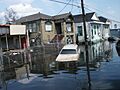
Streets across New Orleans filled with water after floodwalls broke.
-
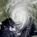
Satellite view of Katrina making its final landfall on the Gulf Coast.
-
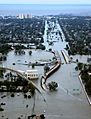
Highway interchanges were completely covered in floodwaters for weeks.
-
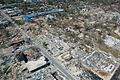
Homes and buildings in Gulfport, Mississippi, were reduced to rubble.
-

Massive storm surge swept through buildings along the Mississippi coastline.
-

Storm surge flooded downtown streets in Mobile, Alabama.
-

Large boats and fishing trawlers washed ashore in Bayou La Batre, Alabama.
-

Map showing the widespread rainfall dropped by Katrina across eastern states.
-

Satellite views showing the erosion of the Chandeleur Islands before and after the storm.
-

Soldiers walking through a New Orleans neighborhood as waters began to recede.
-

Emergency teams conducting door-to-door safety checks across the city.
-

A neighborhood in New Orleans submerged under several feet of water.
-

Journalists were honored with awards for covering the crisis and helping victims.


See also
 In Spanish: Huracán Katrina para niños
- List of Category 5 Atlantic hurricanes
- List of Florida hurricanes (2000–present)
- Wetlands of Louisiana
- Crescent Rising
- Hurricanes and climate change
- Hurricane Katrina in fiction
- Hurricane on the Bayou
- Reconstruction of New Orleans
- Timeline of Hurricane Katrina
- List of conspiracy theories
- List of notable media in the field of meteorology
Other similar tropical cyclones:
- Hurricane Betsy (1965) – A strong hurricane that had a similar path in the Gulf to Katrina.
- Hurricane Camille (1969) – A very powerful Category 5 hurricane that hit similar areas to Katrina.
- Hurricane Andrew (1992) - A Category 5 hurricane that devastated similar areas.
- Hurricane Rita (2005) – Another powerful hurricane that struck the Gulf Coast just a month after Katrina.
- Hurricane Harvey (2017) – A Category 4 hurricane that caused massive flooding in Texas and is tied with Katrina as the costliest tropical cyclone.
- Hurricane Laura (2020) – A Category 4 hurricane that struck Louisiana.
- Hurricane Ida (2021) – A Category 4 hurricane that made landfall in Louisiana.
