
Chandeleur Islands facts for kids

The Chandeleur Islands are a long chain of islands in the Gulf of Mexico. They are about 50 miles (80 km) long. These islands are special because they protect the land behind them from ocean waves. They are the easternmost part of Louisiana, USA. The islands are also part of the Breton National Wildlife Refuge. Many birds stop here during their long journeys south. It's a very important place for wildlife, especially marsh and forest animals.
Contents
A Look Back: The History of the Chandeleur Islands
How the Islands Formed
These islands started forming over 2,000 years ago. They were created from the edge of the Mississippi River delta. This means they were built up by sand and mud carried by the river.
How the Islands Got Their Name
The islands were named by an explorer named Pierre Le Moyne d'Iberville. He was sailing along the Gulf Coast looking for the mouth of the Mississippi River. He named the islands on February 1, 1700. This was the day before a Christian holiday called Fête de la Chandeleur, also known as Candlemas.
Protecting Wildlife: The Breton National Wildlife Refuge
The Breton National Wildlife Refuge was created in 1904. It includes all of the Chandeleur Islands. This refuge is one of the oldest wildlife refuges in the entire National Wildlife Refuge System. It helps protect the animals and plants that live on and around the islands.
Life on the Islands Long Ago
Before a big hurricane hit in 1915, people lived on the islands. There was a small fishing village there. Even earlier, some people tried farming on the islands. A special building called the Chandeleur Island Light was built in 1895. This lighthouse helped sailors and pilots find their way in the Gulf of Mexico.
The Islands and Powerful Storms
How Islands Change Over Time
The Chandeleur Islands are always changing. Ocean waves slowly wear them away. But the biggest changes happen after strong storms called hurricanes. These storms bring huge waves and water surges.
Since the late 1800s, the islands have been getting smaller. They have also been moving closer to the mainland. In the 1980s, experts thought the islands would last for about 300 more years. Before 1996, the islands lost about 20 to 30 feet (6 to 9 meters) of land each year. New land usually formed at the back of the islands.
Big Hurricanes and Big Changes
From 1996 to 2004, the islands started losing land much faster. They lost about 300 feet (91 meters) each year. In 1998, Hurricane Georges hit the islands hard. It damaged them so much that the lighthouse ended up in the middle of the ocean. The islands were just starting to recover when Hurricane Katrina struck on August 29, 2005.

The powerful storms Hurricane Dennis and Hurricane Katrina in 2005 caused huge damage. They turned much of the islands into underwater sandbars. The Chandeleur Island Light also fell over. Strong storms can cause changes that would normally take many years to happen.
A study in 2006 showed that the islands were not rebuilding as they used to. Normally, sand and mud would help them recover after storms. But after Katrina, this did not happen. There is also proof of big underwater landslides. These landslides could let stronger waves reach the islands. This would cause even more erosion. Some experts believe the islands could be mostly underwater in a few decades. This is due to rising sea levels and other issues.
Images for kids
-
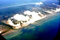
This aerial photo shows oil from the Deepwater Horizon oil spill around the Chandeleur Islands.

