Breton National Wildlife Refuge facts for kids
Quick facts for kids Breton National Wildlife Refuge |
|
|---|---|
|
IUCN Category IV (Habitat/Species Management Area)
|
|
 |
|
| Location | St. Bernard / Plaquemines parishes, Louisiana, United States |
| Nearest city | New Orleans, Louisiana |
| Area | 13,000 acres (53 km2) |
| Established | 1904 |
| Governing body | U.S. Fish and Wildlife Service |
| Website | Breton National Wildlife Refuge |
Breton National Wildlife Refuge is a special place in southeastern Louisiana. It's made up of the Breton Islands and Chandeleur Islands, which are located in the Gulf of Mexico. You can only reach this refuge by boat. President Theodore Roosevelt created it in 1904. This makes it the second-oldest wildlife refuge in the entire National Wildlife Refuge System.
Contents
History of Breton Wildlife Refuge
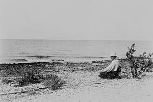
In 1904, President Theodore Roosevelt learned that birds and their eggs were being harmed on the Chandeleur Islands and Breton Islands. Soon after, he created the Breton National Wildlife Refuge (NWR). He even visited the refuge in June 1915, after his time as president had ended. This was the only National Wildlife Refuge Roosevelt ever visited himself.
Over the years, the islands have had a lighthouse, a health checkpoint, a small fishing village, and even an oil production site. However, nature has destroyed these man-made structures. Now, only the birds remain. People like fishermen, birdwatchers, and artists such as Walter Inglis Anderson still enjoy visiting the islands.
In 1915, some families and a school were located on Breton Island. Before a big hurricane hit that year, everyone on the island was moved to safety. The hurricane destroyed the settlement, and it was never rebuilt.
Most of the land in Breton NWR became part of the National Wilderness Preservation System on January 3, 1975. This means it's a protected area where nature is allowed to thrive without much human interference. North Breton Island was not included because an oil facility was located there. The Breton Wilderness is also listed as a Class I Prevention of Significant Deterioration Area under the Clean Air Act. This means the air quality there is highly protected. The only major structure within the wilderness was the Chandeleur Lighthouse, built before the 1900s.
Storm and Hurricane Damage
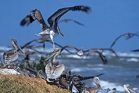
The year 2005 was very tough for the brown pelicans at Breton NWR. In June, Tropical Storm Arlene moved through the Gulf of Mexico. This storm washed over the islands when many young pelicans couldn't fly yet. Many eggs were still in their nests. To make things worse, an oil spill reached the nesting areas, covering many young pelicans in oil. Some pelicans were saved and cleaned, but many more did not survive.
A direct hit from Hurricane Katrina caused a lot of damage to the islands. Large areas of beach and marsh were washed away. Much of the plants that hold the islands together and provide homes for pelicans and other animals were pulled out or damaged. The Chandeleur Island Lighthouse was also destroyed by the hurricane.
Oil Spill Impact
On April 30, 2010, an oil spill from the Deepwater Horizon oil rig reached the wildlife refuge. To protect the nesting seabirds and allow cleanup crews to work, the refuge was closed on May 7, 2010.
Restoration Efforts
The U.S. Fish and Wildlife Service is working with partners to fix the problems caused by the damage to the islands. It would take many years for the islands to heal naturally, if ever. So, they are working to rebuild and plant new vegetation on the islands.
They are also watching the brown pelicans and other birds that come back to nest. They want to see how the storms and oil spill have affected these birds in the long run.
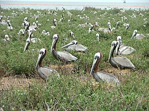
Good news is that wildlife seems to be recovering. In 2007, as many as 2,000 brown pelican nests were reported on the refuge. The pelican nests, eggs, and chicks are still at risk during hurricane season. They are vulnerable until they can fly and find food on their own.
Currently, efforts are underway to rebuild Breton Island. This project will add 53 acres of new nesting habitat for birds.
Geography of the Islands
Breton NWR includes Breton Island in Plaquemines Parish and all of the Chandeleur Islands in St. Bernard Parish, Louisiana. These islands are what's left of the Mississippi River's old St. Bernard Delta. This delta was active about 2,000 years ago.
These islands are always changing. Their sizes and shapes are constantly altered by tropical storms, wind, and the movement of tides. The area above the average high tide is about 6,923 acres (28.02 km2). The highest points on Breton NWR are about 19 ft (5.8 m) above sea level. Older writings about Breton and the Chandeleur Islands mention trees and higher land than what exists today.
Animals of Breton NWR (Fauna)
Breton NWR is home to large groups of nesting wading birds and seabirds. It also hosts shorebirds and waterfowl during the winter. Twenty-three different types of seabirds and shorebirds often use the refuge. Thirteen species actually build their nests on the various islands.
The most common birds that nest here are brown pelicans, laughing gulls, and different kinds of terns like royal, Caspian, and Sandwich terns. Waterfowl spend their winters near the refuge islands. They use the shallow waters, marshes, and sounds to find food and stay safe during bad weather. Redheads and lesser scaup are the most common waterfowl. Other animals found on the refuge include coypu, rabbits, raccoons, and loggerhead sea turtles.
Plants of Breton NWR (Flora)
The main plants found on Breton NWR are black mangrove (Avicennia germinans), groundsel bush (Baccharis halimifolia), and wax myrtle (Myrica cerifera). The shallow bay waters around the islands have beds of different types of seagrass. These include manatee grass (Cymodocea filiformis), shoal grass (Halodule wrightii), turtle grass (Thalassia testudinum), and widgeon grass (Ruppia maritima).
 | Sharif Bey |
 | Hale Woodruff |
 | Richmond Barthé |
 | Purvis Young |


