
Bayou La Batre, Alabama facts for kids
Quick facts for kids
Bayou La Batre, Alabama
|
|||
|---|---|---|---|
|
|||

Location of in Mobile County, Alabama
|
|||
| Country | United States | ||
| State | Alabama | ||
| County | Mobile | ||
| Area | |||
| • Total | 7.63 sq mi (19.77 km2) | ||
| • Land | 7.49 sq mi (19.40 km2) | ||
| • Water | 0.14 sq mi (0.37 km2) | ||
| Elevation | 10 ft (3 m) | ||
| Population
(2020)
|
|||
| • Total | 2,204 | ||
| • Density | 294.26/sq mi (113.62/km2) | ||
| Time zone | UTC-6 (Central (CST)) | ||
| • Summer (DST) | UTC-5 (CDT) | ||
| ZIP code |
36509
|
||
| Area code(s) | 251 | ||
| FIPS code | 01-04684 | ||
| GNIS feature ID | 2403828 | ||


Bayou La Batre is a city in Mobile County, Alabama, United States. It is part of the Mobile metropolitan area. As of the 2020 census, 2,204 people lived there. This was a decrease from 2,558 people in 2010.
Bayou La Batre is a fishing town. It has a harbor where seafood is processed from many fishing boats and shrimp boats. The local business group calls the city the "Seafood Capitol of Alabama." This is because so much seafood is packaged there.
The city was founded in 1786. A French-born man named Joseph Bouzage was given a large piece of land. The modern city of Bayou La Batre became official in 1955.
On August 29, 2005, Hurricane Katrina hit the area hard. It caused the biggest storm surge ever recorded there, nearly 16 feet high. Many shrimp boats and a cargo ship were pushed onto the land.
Contents
History of Bayou La Batre
The bayou was first called "Riviere D'Erbane" by the French settlers. It got its current name from a French artillery battery (a group of cannons) on the west bank. So, "Bayou La Batre" means "bayou of the battery."
Bayou La Batre was the first lasting settlement in southern Mobile County. It was started in 1786. Joseph Bouzage moved to the area and received a large Spanish land grant. This land was on the west bank of the bayou.
Joseph Bouzage was born in Poitiers, France. He came to the Gulf Coast around 1760. He married Catherine Louise Baudreau in 1762. They had seven children together.
Hurricane Katrina's Impact

On August 29, 2005, Hurricane Katrina caused a lot of damage. The storm surge was almost 16 feet high. This pushed more than 23 shrimp boats and the cargo ship M/V Caribbean Clipper onto the shore. The ship's captain stayed on the 179-foot cargo ship during the storm. The ship was returned to the sea six months later using a huge crane.
The Bayou La Batre Public Library was destroyed by the hurricane. Students from Alba Middle School took photos of the damage. These photos were shown in Alabama and Illinois. They were also published in a book called Eyes of the Storm: A Community Survives after Katrina.
After the hurricane, high school students from Truckee, California, helped Bayou La Batre. They sent money, supplies, and 15 students to help rebuild homes. They also set up a pen pal program with students in Bayou La Batre.
In October 2005, the city of Santa Monica, California also helped. They loaned Bayou La Batre 18 vehicles. These included pickup trucks, trucks with cranes, and street sweepers. This equipment helped remove debris and fishing boats from the city.
Shipbuilding in Bayou La Batre
Bayou La Batre is a major place for shipbuilding. Many shipyards there are owned by local families. Some of these include Steiner Ship Yard and Master Boat Builders.
People from all over the world come to Bayou La Batre to have boats built. In 2005, Steiner Ship Yard built a pirate ship for Walt Disney Studios. This ship, the Black Pearl, was a large wooden prop. It was built on top of a modern steel utility boat. Crews sailed it to the Caribbean for filming the "Pirates of the Caribbean" movies.
Another famous ship, the FV Cornelia Marie, was built here in 1989. This ship is known from the TV show "Deadliest Catch."
Geography and Climate
Bayou La Batre is in southern Mobile County. The waterway called Bayou La Batre runs through the city. It leads southwest about 2 miles to Portersville Bay. This bay is part of Mississippi Sound in the Gulf of Mexico.
The city is about 27 miles south of Mobile. It is also about 12 miles east of the Mississippi border. The city covers about 7.6 square miles. Most of this area is land, with a small part being water.
Local Climate
The weather in this area has hot, humid summers. Winters are usually mild to cool. Bayou La Batre has a humid subtropical climate. This means it gets a lot of rain and has warm temperatures for most of the year.
| Climate data for Bayou La Batre, Alabama | |||||||||||||
|---|---|---|---|---|---|---|---|---|---|---|---|---|---|
| Month | Jan | Feb | Mar | Apr | May | Jun | Jul | Aug | Sep | Oct | Nov | Dec | Year |
| Mean daily maximum °C (°F) | 16 (61) |
17 (63) |
21 (70) |
25 (77) |
28 (83) |
31 (88) |
32 (90) |
32 (89) |
31 (87) |
26 (79) |
22 (71) |
17 (63) |
25 (77) |
| Mean daily minimum °C (°F) | 4 (39) |
6 (42) |
9 (48) |
13 (56) |
17 (63) |
21 (69) |
22 (72) |
22 (72) |
20 (68) |
14 (57) |
8 (47) |
6 (42) |
13 (56) |
| Average precipitation mm (inches) | 140 (5.5) |
140 (5.4) |
150 (5.8) |
120 (4.7) |
120 (4.6) |
140 (5.4) |
190 (7.4) |
180 (7) |
160 (6.2) |
97 (3.8) |
100 (4.1) |
120 (4.7) |
1,640 (64.7) |
| Source: Weatherbase | |||||||||||||
Population Facts
| Historical population | |||
|---|---|---|---|
| Census | Pop. | %± | |
| 1950 | 2,196 | — | |
| 1960 | 2,572 | 17.1% | |
| 1970 | 2,664 | 3.6% | |
| 1980 | 2,005 | −24.7% | |
| 1990 | 2,456 | 22.5% | |
| 2000 | 2,313 | −5.8% | |
| 2010 | 2,558 | 10.6% | |
| 2020 | 2,204 | −13.8% | |
| U.S. Decennial Census 2013 Estimate |
|||
A census is an official count of the population. It helps us understand how many people live in a place and what groups they belong to.
2020 Census Details
| Race | Num. | Perc. |
|---|---|---|
| White (non-Hispanic) | 1,306 | 59.26% |
| Black or African American (non-Hispanic) | 273 | 12.39% |
| Native American | 4 | 0.18% |
| Asian | 420 | 19.06% |
| Pacific Islander | 1 | 0.05% |
| Other/Mixed | 101 | 4.58% |
| Hispanic or Latino | 99 | 4.49% |
In 2020, there were 2,204 people living in Bayou La Batre. There were 837 households and 638 families.
2010 Census Details
In 2010, Bayou La Batre had 2,558 people. The population was made up of different groups:
- 60.3% White
- 12.3% Black or African American
- 0.4% Native American
- 22.8% Asian
- 0.1% Pacific Islander
- 1.0% from some other race
- 3.2% from two or more races
- 2.8% were Hispanic or Latino (of any race)
Education in the City
The Mobile County Public School System serves Bayou La Batre. The city has Booth Elementary School and Alba Middle School. All high school students attend Alma Bryant High School. A few children also go to Dixon Elementary in Irvington.
Alma Bryant High and Booth Elementary are on the northern edge of the city. Bryant High was built in 1998. Booth Elementary was built in 2006. Both schools are located on Hurricane Boulevard.
In December 2007, a new library opened. It helps the area's Asian-American community. The library is in the Bayou La Batre office of Boat People SOS. This is a group that helps Vietnamese-Americans. The library helps older immigrants learn computer skills. Children can practice Vietnamese after school. Day laborers can use the internet after work.
Famous People from Bayou La Batre
- Regina Benjamin, who used to be the top doctor for the United States (the United States Surgeon General)
- Antwan Odom, an American football player for the NFL team, the Cincinnati Bengals
Images for kids
-
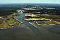
An aerial view of Bayou La Batre from the harbor entrance on the Gulf of Mexico.
-
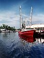
A fishing boat docked in Bayou La Batre.


See also
 In Spanish: Bayou La Batre para niños
