
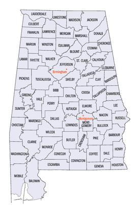
List of counties in Alabama facts for kids
Quick facts for kids Counties of Alabama |
|
|---|---|
| Location | State of Alabama |
| Number | 67 |
| Populations | Greatest: 662,895 (Jefferson) Least: 7,341 (Greene) Average: 76,246 (2023) |
| Areas | Largest: 1,590 sq mi (4,100 km2) (Baldwin) Smallest: 535 sq mi (1,390 km2) (Etowah) Average: 782 sq mi (2,030 km2) |
| Government | County government |
| Subdivisions | cities, towns, unincorporated communities, census designated place |
The U.S. state of Alabama has 67 counties. Each county acts like a local government area within its own borders. The land that makes up Alabama today joined the United States over time. After the American Revolutionary War, some parts were given to Spain, while most became the Mississippi Territory and later the Alabama Territory.
The first county, Washington County, was created on June 4, 1800. In 1814, a special agreement called the Treaty of Fort Jackson opened up more land for American settlers. This led to many new counties being formed quickly. Alabama officially became the 22nd state in 1819.
More counties were added as new settlers moved into areas that were once Native American lands. By 1820, Alabama had 29 counties. This number grew to 36 by 1830, 49 by 1840, 52 by 1850, and 65 by 1870. The last county, Houston County, was created on February 9, 1903, bringing the total to 67.
Contents
Understanding Alabama's Counties
According to information from 2023, the average population for an Alabama county is about 76,246 people. Jefferson County is the largest with 662,895 people. The smallest is Greene County with only 7,341 people.
When it comes to size, the average land area for a county is about 756 square miles (1,958 square kilometers). Baldwin County is the biggest, covering 1,590 square miles (4,118 square kilometers). Etowah County is the smallest at 535 square miles (1,386 square kilometers).
Alabama's state rules say that any new county must be at least 600 square miles (1,554 square kilometers) in size. This rule makes it hard to create new counties today.
How Counties Get Their Names
Many counties in Alabama are named after important people or places. Some are named after famous American leaders, like presidents or generals. Others are named after Native American tribes or local rivers and landmarks. For example:
- Baldwin County is named after Abraham Baldwin, a U.S. legislator from Georgia.
- Cherokee County is named after the Cherokee people, who lived on those lands.
- Jefferson County is named after Thomas Jefferson, the 3rd U.S. President.
- Mobile County is named after Mobile Bay, which got its name from the Maubila Native American tribe.
License Plates and County Numbers
When you see a car in Alabama, its license plate has a special number that tells you which county the vehicle is registered in. This number is usually one or two digits. The counties with the most people historically get the first few numbers (1, 2, 3). After that, the numbers are given out in alphabetical order based on the county name.
For example, Jefferson County (the most populated) has the number 1. Mobile County has number 2, and Montgomery County has number 3.
What is a FIPS Code?
The U.S. government uses something called a Federal Information Processing Standard (FIPS) code to give each county a unique number. This helps keep track of information about counties across the country. Alabama's state FIPS code is 01. Each county then has its own unique three-digit number that follows the state code.
List of Alabama Counties
Here is a list of all 67 counties in Alabama, along with their county seats (the main town where the county government is located), when they were created, and what they were named after.
| County |
FIPS code | County seat | License # |
Est. | Formed from | Etymology | Density |
Population (2023) | Land Area | Map |
|---|---|---|---|---|---|---|---|---|---|---|
| Autauga County | 001 | Prattville | 4 | 1818 | Montgomery County | The Autauga or Atagi people, Native Americans who were a sub-group of the Alibamu | 101.5 | 60,342 | 594.44 sq mi (1,540 km2) |
 |
| Baldwin County | 003 | Bay Minette | 5 | 1809 | Washington County and West Florida | Abraham Baldwin (1754–1807), U.S. legislator from Georgia | 159.5 | 253,507 | 1,589.78 sq mi (4,118 km2) |
 |
| Barbour County | 005 | Clayton | 6 | 1832 | Pike County | James Barbour (1775–1842), Governor of Virginia and U.S. Senator | 27.8 | 24,585 | 884.88 sq mi (2,292 km2) |
 |
| Bibb County | 007 | Centreville | 7 | 1818 | Montgomery County (as Cahawba County) | William Wyatt Bibb (1781–1820), 1st Governor of Alabama | 35.1 | 21,868 | 622.58 sq mi (1,612 km2) |
 |
| Blount County | 009 | Oneonta | 8 | 1818 | Montgomery County and Creek territories | Willie Blount (1768–1835), Governor of Tennessee | 92.8 | 59,816 | 644.78 sq mi (1,670 km2) |
 |
| Bullock County | 011 | Union Springs | 9 | 1866 | Barbour, Macon, Montgomery, and Pike counties | Edward Bullock (1822–1861), colonel in the Confederate States Army | 15.9 | 9,897 | 622.80 sq mi (1,613 km2) |
 |
| Butler County | 013 | Greenville | 10 | 1819 | Conecuh and Monroe counties | William Butler (1759–1818), captain in Creek War | 23.7 | 18,382 | 776.83 sq mi (2,012 km2) |
 |
| Calhoun County | 015 | Anniston | 11 | 1832 | St. Clair County (as Benton County) | John C. Calhoun (1782–1850), 7th U.S. Vice President | 192.2 | 116,429 | 605.87 sq mi (1,569 km2) |
 |
| Chambers County | 017 | LaFayette | 12 | 1832 | Montgomery County | Henry H. Chambers (1790–1826), U.S. Senator | 57.1 | 34,079 | 596.53 sq mi (1,545 km2) |
 |
| Cherokee County | 019 | Centre | 13 | 1836 | Cherokee territory | Cherokee people, whose lands included Northeast Alabama | 46.4 | 25,666 | 553.70 sq mi (1,434 km2) |
 |
| Chilton County | 021 | Clanton | 14 | 1868 | Autauga, Bibb, Perry, and Shelby counties (as Baker County) | William Parish Chilton (1810–1871), Alabama Supreme Court Justice and Confederate congressman | 67.0 | 46,431 | 692.85 sq mi (1,794 km2) |
 |
| Choctaw County | 023 | Butler | 15 | 1847 | Sumter and Washington counties | Choctaw people, whose lands included Alabama | 13.4 | 12,252 | 913.50 sq mi (2,366 km2) |
 |
| Clarke County | 025 | Grove Hill | 16 | 1812 | Washington County | John Clarke (1766–1832), general from Georgia | 18.0 | 22,337 | 1,238.46 sq mi (3,208 km2) |
 |
| Clay County | 027 | Ashland | 17 | 1866 | Randolph and Talladega counties | Henry Clay (1777–1852), U.S. legislator from Kentucky | 23.4 | 14,111 | 603.96 sq mi (1,564 km2) |
 |
| Cleburne County | 029 | Heflin | 18 | 1866 | Calhoun, Randolph, and Talladega counties | Patrick Cleburne (1828–1864), Major General in Confederate States Army | 27.9 | 15,639 | 560.10 sq mi (1,451 km2) |
 |
| Coffee County | 031 | Elba and Enterprise | 19 | 1841 | Dale County | John Coffee (1772–1833), military leader in War of 1812 and Creek War | 82.0 | 55,643 | 678.97 sq mi (1,759 km2) |
 |
| Colbert County | 033 | Tuscumbia | 20 | 1867 | Franklin County | George Colbert (1764–1839) and Levi Colbert (1759–1834), Chickasaw chiefs | 98.5 | 58,361 | 592.62 sq mi (1,535 km2) |
 |
| Conecuh County | 035 | Evergreen | 21 | 1818 | Monroe County | The Conecuh River, which flows through the county | 13.1 | 11,174 | 850.16 sq mi (2,202 km2) |
 |
| Coosa County | 037 | Rockford | 22 | 1832 | Montgomery County | The Coosa River, which flows through the county, and is itself named after a Native American village | 15.8 | 10,268 | 650.93 sq mi (1,686 km2) |
 |
| Covington County | 039 | Andalusia | 23 | 1821 | Henry County | Leonard Covington (1768–1813), Brigadier General in War of 1812 and U.S. Congressman | 36.8 | 37,952 | 1,030.46 sq mi (2,669 km2) |
 |
| Crenshaw County | 041 | Luverne | 24 | 1866 | Butler, Coffee, Covington, Lowndes, and Pike Counties | Anderson Crenshaw (1783–1847), Alabama Supreme Court justice and early settler | 21.5 | 13,101 | 608.84 sq mi (1,577 km2) |
 |
| Cullman County | 043 | Cullman | 25 | 1877 | Blount, Morgan, and Winston counties | Colonel John G. Cullmann (1823–1895), founder of county seat | 125.2 | 92,016 | 734.84 sq mi (1,903 km2) |
 |
| Dale County | 045 | Ozark | 26 | 1824 | Covington and Henry counties | Samuel Dale (1772–1841), Brigadier General and state legislator | 88.9 | 49,871 | 561.15 sq mi (1,453 km2) |
 |
| Dallas County | 047 | Selma | 27 | 1818 | Monroe and Montgomery counties | Alexander James Dallas (1759–1817), U.S. Secretary of Treasury | 37.0 | 36,165 | 978.69 sq mi (2,535 km2) |
 |
| DeKalb County | 049 | Fort Payne | 28 | 1836 | Cherokee territory | Johann de Kalb (1721–1780), major general in American Revolutionary War | 93.4 | 72,569 | 777.09 sq mi (2,013 km2) |
 |
| Elmore County | 051 | Wetumpka | 29 | 1866 | Autauga, Coosa, Montgomery, and Tallapoosa counties | John Archer Elmore (1762–1834), Revolutionary War veteran | 146.2 | 90,441 | 618.48 sq mi (1,602 km2) |
 |
| Escambia County | 053 | Brewton | 30 | 1868 | Baldwin and Conecuh counties | Escambia Creek, a tributary of the Conecuh River | 38.7 | 36,558 | 945.08 sq mi (2,448 km2) |
 |
| Etowah County | 055 | Gadsden | 31 | 1866 | Blount, Calhoun, Cherokee, DeKalb, Marshall, and St. Clair counties (as Baine County) | Etowah Indian Mounds | 193.0 | 103,241 | 534.99 sq mi (1,386 km2) |
 |
| Fayette County | 057 | Fayette | 32 | 1824 | Marion, Pickens, Tuscaloosa, and Walker counties | Gilbert du Motier, marquis de La Fayette (1757–1834), Revolutionary War commander | 25.4 | 15,967 | 627.66 sq mi (1,626 km2) |
 |
| Franklin County | 059 | Russellville | 33 | 1818 | Cherokee territory | Benjamin Franklin (1706–1790), politician, diplomat, inventor, and publisher | 50.2 | 31,802 | 633.82 sq mi (1,642 km2) |
 |
| Geneva County | 061 | Geneva | 34 | 1868 | Coffee, Dale, and Henry counties | Named after Geneva, New York, the origin of several early settlers | 47.0 | 26,988 | 574.41 sq mi (1,488 km2) |
 |
| Greene County | 063 | Eutaw | 35 | 1819 | Marengo and Tuscaloosa counties | Nathanael Greene (1742–1786), Revolutionary War general | 11.3 | 7,341 | 647.11 sq mi (1,676 km2) |
 |
| Hale County | 065 | Greensboro | 36 | 1867 | Greene, Marengo, Perry, and Tuscaloosa counties | Stephen F. Hale (1816–1862), lieutenant colonel in Confederate States Army | 23.1 | 14,888 | 643.94 sq mi (1,668 km2) |
 |
| Henry County | 067 | Abbeville | 37 | 1819 | Conecuh County | Patrick Henry (1736–1799), Revolutionary War patriot and Governor of Virginia | 31.9 | 17,899 | 561.75 sq mi (1,455 km2) |
 |
| Houston County | 069 | Dothan | 38 | 1903 | Dale, Geneva, and Henry counties | George S. Houston (1811–1879), 24th Governor of Alabama and U.S. Congressman | 187.1 | 108,462 | 579.82 sq mi (1,502 km2) |
 |
| Jackson County | 071 | Scottsboro | 39 | 1819 | Cherokee territory | Andrew Jackson (1767–1845), 7th U.S. President | 49.6 | 53,467 | 1,077.87 sq mi (2,792 km2) |
 |
| Jefferson County | 073 | Birmingham | 1 | 1819 | Blount County | Thomas Jefferson (1743–1826), 3rd U.S. President | 596.5 | 662,895 | 1,111.28 sq mi (2,878 km2) |
 |
| Lamar County | 075 | Vernon | 40 | 1867 | Fayette and Marion counties (as Jones County) | Lucius Q. C. Lamar (1825–1893), U.S. Supreme Court justice | 22.6 | 13,661 | 604.85 sq mi (1,567 km2) |
 |
| Lauderdale County | 077 | Florence | 41 | 1818 | Cherokee and Chickasaw territories | James Lauderdale (1780–1814), Colonel in War of 1812 | 145.0 | 96,814 | 667.70 sq mi (1,729 km2) |
 |
| Lawrence County | 079 | Moulton | 42 | 1818 | Cherokee territory | James Lawrence (1781–1813), naval officer in War of 1812 | 48.5 | 33,502 | 690.68 sq mi (1,789 km2) |
 |
| Lee County | 081 | Opelika | 43 | 1866 | Chambers, Macon, Russell, and Tallapoosa counties | Robert E. Lee (1807–1870), Commander of the Confederate States Army | 301.6 | 183,215 | 607.54 sq mi (1,574 km2) |
 |
| Limestone County | 083 | Athens | 44 | 1818 | Elk and Madison counties | Limestone Creek, named for local geological deposits | 204.8 | 114,654 | 559.94 sq mi (1,450 km2) |
 |
| Lowndes County | 085 | Hayneville | 45 | 1830 | Butler, Dallas, and Montgomery counties | William Lowndes (1782–1822), U.S. Congressman from South Carolina | 13.6 | 9,717 | 715.91 sq mi (1,854 km2) |
 |
| Macon County | 087 | Tuskegee | 46 | 1832 | Montgomery County | Nathaniel Macon (1758–1837), U.S. legislator from North Carolina | 30.2 | 18,370 | 608.89 sq mi (1,577 km2) |
 |
| Madison County | 089 | Huntsville | 47 | 1808 | Cherokee and Chickasaw territories | James Madison (1751–1836), 4th U.S. President | 514.7 | 412,600 | 801.59 sq mi (2,076 km2) |
 |
| Marengo County | 091 | Linden | 48 | 1818 | Choctaw territory | Battle of Marengo | 19.1 | 18,684 | 976.88 sq mi (2,530 km2) |
 |
| Marion County | 093 | Hamilton | 49 | 1818 | Tuscaloosa County | Francis Marion (1732–1795), military leader in American Revolutionary War | 39.4 | 29,244 | 742.29 sq mi (1,923 km2) |
 |
| Marshall County | 095 | Guntersville | 50 | 1836 | Blount and Jackson counties and Cherokee territory | John Marshall (1755–1835), Chief Justice of the United States 1801–1835 | 178.1 | 100,756 | 565.84 sq mi (1,466 km2) |
 |
| Mobile County | 097 | Mobile | 2 | 1812 | Mobile District of West Florida after annexation into Mississippi Territory | Mobile Bay, on which county is located, and which is itself named after the Maubila tribe of Native Americans | 334.8 | 411,640 | 1,229.44 sq mi (3,184 km2) |
 |
| Monroe County | 099 | Monroeville | 51 | 1815 | Creek territory | James Monroe (1758–1831), 5th U.S. President | 18.7 | 19,229 | 1,025.67 sq mi (2,656 km2) |
 |
| Montgomery County | 101 | Montgomery | 3 | 1816 | Monroe County | Lemuel P. Montgomery (1786–1814), Major in Creek War | 286.9 | 224,980 | 784.25 sq mi (2,031 km2) |
 |
| Morgan County | 103 | Decatur | 52 | 1818 | Cherokee territory (as Cotaco County) | Daniel Morgan (1736–1802), U.S. Congressman | 216.0 | 125,133 | 579.34 sq mi (1,500 km2) |
 |
| Perry County | 105 | Marion | 53 | 1819 | Cahawba, Dallas, Marengo, and Tuscaloosa counties | Oliver Hazard Perry (1795–1819), naval officer in War of 1812 | 10.8 | 7,738 | 719.66 sq mi (1,864 km2) |
 |
| Pickens County | 107 | Carrollton | 54 | 1820 | Tuscaloosa County | Andrew Pickens (1739–1817), General in the Revolutionary War | 21.2 | 18,688 | 881.41 sq mi (2,283 km2) |
 |
| Pike County | 109 | Troy | 55 | 1821 | Henry and Montgomery counties | Zebulon Pike (1779–1813), explorer and officer in War of 1812 | 49.3 | 33,137 | 672.09 sq mi (1,741 km2) |
 |
| Randolph County | 111 | Wedowee | 56 | 1832 | St. Clair and Shelby counties | John Randolph (1773–1833), U.S. Senator from Virginia | 39.2 | 22,786 | 580.55 sq mi (1,504 km2) |
 |
| Russell County | 113 | Phenix City | 57 | 1832 | Barbour, Bullock, Lee and Macon counties | Gilbert C. Russell (1782–1861), officer in Creek War | 91.6 | 58,744 | 641.14 sq mi (1,661 km2) |
 |
| St. Clair County | 115 | Ashville and Pell City | 59 | 1818 | Shelby County | Arthur St. Clair (1736–1818), President of Continental Congress | 151.2 | 95,552 | 631.90 sq mi (1,637 km2) |
 |
| Shelby County | 117 | Columbiana | 58 | 1818 | Montgomery County | Isaac Shelby (1750–1826), Governor of Kentucky | 296.8 | 233,000 | 784.93 sq mi (2,033 km2) |
 |
| Sumter County | 119 | Livingston | 60 | 1832 | Choctaw territory | Thomas Sumter (1734–1832), U.S. Congressman from South Carolina | 13.0 | 11,727 | 903.89 sq mi (2,341 km2) |
 |
| Talladega County | 121 | Talladega | 61 | 1832 | St. Clair and Shelby counties | Talatigi, Creek Indian name for the county seat, meaning "border town" | 110.1 | 81,132 | 736.78 sq mi (1,908 km2) |
 |
| Tallapoosa County | 123 | Dadeville | 62 | 1832 | Montgomery and Shelby counties | Tallapoosa River | 56.8 | 40,677 | 716.52 sq mi (1,856 km2) |
 |
| Tuscaloosa County | 125 | Tuscaloosa | 63 | 1818 | Montgomery County and Choctaw territory | Iroquoian name for the Black Warrior River | 179.6 | 237,373 | 1,321.75 sq mi (3,423 km2) |
 |
| Walker County | 127 | Jasper | 64 | 1823 | Blount, Jefferson, and Tuscaloosa counties | John Williams Walker (1783–1823), U.S. Senator from Alabama | 81.8 | 64,728 | 791.19 sq mi (2,049 km2) |
 |
| Washington County | 129 | Chatom | 65 | 1800 | Adams and Pickering counties of Mississippi Territory | George Washington (1732–1799), 1st U.S. President | 13.9 | 15,022 | 1,080.21 sq mi (2,798 km2) |
 |
| Wilcox County | 131 | Camden | 66 | 1819 | Dallas and Monroe counties | Joseph M. Wilcox (1790–1814), lieutenant in Creek War | 11.2 | 9,944 | 888.50 sq mi (2,301 km2) |
 |
| Winston County | 133 | Double Springs | 67 | 1850 | Walker County (as Hancock County) | John A. Winston (1812–1871), 15th Governor of Alabama | 38.5 | 23,611 | 612.98 sq mi (1,588 km2) |
 |
Former County Names and Counties
Over time, some counties in Alabama have changed their names, and a few counties that once existed are no longer around. This often happened as the state grew and new areas were settled.
Counties with Changed Names
Some counties were originally named something else before their current names. Here are a few examples:
| Original Name | Named for | Changed to |
|---|---|---|
| Baine County | David W. Baine, a Colonel in the Civil War | Etowah County in 1868 |
| Baker County | Alfred Baker, a local landowner | Chilton County in 1874 |
| Benton County | Thomas Hart Benton, a U.S. Senator | Calhoun County in 1858, named after Benton's rival John C. Calhoun |
| Cahawba County | The former state capital of Cahawba | Bibb County in 1820 |
Counties That No Longer Exist
A couple of counties were created but later dissolved, meaning their land was split up and added to other existing counties.
| County | Established | Dissolved | Named for | Notes |
|---|---|---|---|---|
| Decatur County | December 7, 1821 | December 28, 1825 | Commodore Stephen Decatur of the United States Navy. | This county was created in 1822 but was later divided between Madison County and Jackson County. |
| Elk County | May 9, 1817 | January 26, 1818 | Elk River | This county was formed before Alabama became a state and was dissolved before statehood. |
See also
 In Spanish: Anexo:Condados de Alabama para niños
