Dale County, Alabama facts for kids
Quick facts for kids
Dale County
|
||
|---|---|---|

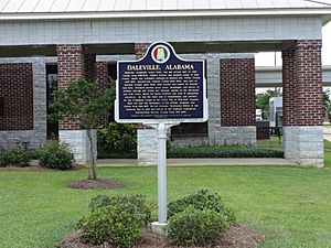
Daleville historical marker
|
||
|
||

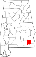
Location within the U.S. state of Alabama
|
||
 Alabama's location within the U.S. |
||
| Country | ||
| State | ||
| Founded | December 22, 1824 | |
| Named for | Samuel Dale | |
| Seat | Ozark | |
| Largest city | Ozark | |
| Area | ||
| • Total | 563 sq mi (1,460 km2) | |
| • Land | 561 sq mi (1,450 km2) | |
| • Water | 1.6 sq mi (4 km2) 0.3% | |
| Population
(2020)
|
||
| • Total | 49,326 | |
| • Estimate
(2023)
|
49,871 |
|
| • Density | 87.61/sq mi (33.827/km2) | |
| Time zone | UTC−6 (Central) | |
| • Summer (DST) | UTC−5 (CDT) | |
| Congressional district | 2nd | |
|
||
Dale County is a county located in the southeastern part of Alabama, a state in the United States. A county is like a smaller area within a state, often with its own local government. In 2020, about 49,326 people lived here. The main city and where the county government is located is Ozark. The county is named after General Samuel Dale, a famous soldier.
Dale County is part of the Ozark, AL Micropolitan Statistical Area. This means it's a smaller urban area that is connected to the bigger Dothan area. A large military base, Fort Novosel (which used to be called Fort Rucker), is mostly located in Dale County.
Contents
History of Dale County
The land that is now Dale County was first home to the Creek Indian nation. They lived throughout southeastern Alabama for a long time. From 1764 to 1783, this area was controlled by the British colony of British West Florida.
The land became part of the United States in 1814 after the Treaty of Fort Jackson. This treaty ended the Creek War. Around 1820, soldiers who fought in the war started to settle in the area.
Dale County was officially created on December 22, 1824. It was much larger back then, including parts of what are now Coffee County and Geneva County. The first county seat was a town called Dale's Court House, which is now Daleville.
Over time, the county's borders changed. When Coffee County became its own county in 1841, the county seat moved to Newton. After a courthouse fire in 1869 and the creation of Geneva County, the county seat moved again in 1870 to Ozark, where it is today. In 1903, a small part of Dale County joined the new Houston County.
Dale County in the Civil War
During the U.S. Civil War, many soldiers from Dale County joined the fight. Parts of the 15th Regiment of Alabama Infantry were from Dale County. This group was very brave and fought in many important battles.
One of their most famous moments was at the Battle of Gettysburg on July 2, 1863. They fought bravely against the 20th Maine regiment on a hill called Little Round Top. Even though they attacked many times, they couldn't win the hill and had to retreat. This battle was shown in the 1993 movie Gettysburg. The 15th Regiment continued fighting until the end of the war in 1865.
Another group, the 33rd Alabama Regiment, also had many soldiers from Dale County. They fought bravely in the Army of Tennessee. They were even thanked by the Confederate Congress for their actions at Ringgold Gap. This regiment faced very tough battles, like Perryville and Franklin. Only a few soldiers from this group returned home after the war.
Geography
Dale County covers about 563 square miles. Most of this area, about 561 square miles, is land, and a small part is water. The county is located in the Wiregrass Region of southeastern Alabama.
It is one of the smaller counties in Alabama.
Main Roads
Neighboring Counties
- Pike County (northwest)
- Barbour County (north)
- Henry County (east)
- Houston County (southeast)
- Geneva County (southwest)
- Coffee County (west)
People of Dale County (Demographics)
| Historical population | |||
|---|---|---|---|
| Census | Pop. | %± | |
| 1830 | 2,031 | — | |
| 1840 | 7,397 | 264.2% | |
| 1850 | 6,382 | −13.7% | |
| 1860 | 12,197 | 91.1% | |
| 1870 | 11,325 | −7.1% | |
| 1880 | 12,677 | 11.9% | |
| 1890 | 17,225 | 35.9% | |
| 1900 | 21,189 | 23.0% | |
| 1910 | 21,608 | 2.0% | |
| 1920 | 22,711 | 5.1% | |
| 1930 | 23,175 | 2.0% | |
| 1940 | 22,685 | −2.1% | |
| 1950 | 20,828 | −8.2% | |
| 1960 | 31,066 | 49.2% | |
| 1970 | 52,995 | 70.6% | |
| 1980 | 47,821 | −9.8% | |
| 1990 | 49,633 | 3.8% | |
| 2000 | 49,129 | −1.0% | |
| 2010 | 50,251 | 2.3% | |
| 2020 | 49,326 | −1.8% | |
| 2023 (est.) | 49,871 | −0.8% | |
| U.S. Decennial Census 1790–1960 1900–1990 1990–2000 2010–2020 |
|||
2020 Census Information
| Race / Ethnicity (NH = Non-Hispanic) | Pop 2000 | Pop 2010 | Pop 2020 | % 2000 | % 2010 | % 2020 |
|---|---|---|---|---|---|---|
| White alone (NH) | 35,771 | 35,705 | 32,602 | 72.81% | 71.05% | 66.09% |
| Black or African American alone (NH) | 9,902 | 9,546 | 10,100 | 20.16% | 19.00% | 20.48% |
| Native American or Alaska Native alone (NH) | 285 | 337 | 217 | 0.58% | 0.67% | 0.44% |
| Asian alone (NH) | 518 | 527 | 648 | 1.05% | 1.05% | 1.31% |
| Pacific Islander alone (NH) | 67 | 42 | 42 | 0.14% | 0.08% | 0.09% |
| Other race alone (NH) | 65 | 66 | 164 | 0.13% | 0.13% | 0.33% |
| Mixed race or Multiracial (NH) | 879 | 1,207 | 2,299 | 1.79% | 2.40% | 4.66% |
| Hispanic or Latino (any race) | 1,642 | 2,821 | 3,254 | 3.34% | 5.61% | 6.60% |
| Total | 49,129 | 50,251 | 49,326 | 100.00% | 100.00% | 100.00% |
In 2020, there were 49,326 people living in Dale County. There were 18,806 households (groups of people living together) and 12,515 families.
2010 Census Information
In 2010, Dale County had 50,251 people. About 74.1% of the people were White, 19.3% were Black or African American, and 5.6% were Hispanic or Latino (who can be of any race).
About 30.1% of households had children under 18. The average household had 2.46 people. The median age was 36.1 years old. This means half the people were younger than 36.1 and half were older.
The median income for a household was $43,353. This is the middle income for all households. About 14.8% of the people in the county lived below the poverty line.
Education
Most students in Dale County go to schools run by the Dale County School District. However, some towns have their own school districts. These include Daleville City School District, Dothan City School District, Enterprise City School District, and Ozark City School District.
Children living on the Fort Novosel military base go to elementary schools run by the Department of Defense Education Activity (DoDEA). For middle and high school, students from Fort Novosel can choose to attend schools in Daleville City, Enterprise City, or Ozark City.
Communities
Cities
- Daleville
- Dothan (partly in Houston County and Henry County)
- Enterprise (partly in Coffee County)
- Level Plains
- Ozark (county seat)
Towns
Census-designated place
- Fort Novosel (U.S. Army base)
Unincorporated communities
Notable people
- Nolan Williams (1941-2022), an Alabama state representative.
See also
 In Spanish: Condado de Dale para niños
 | Isaac Myers |
 | D. Hamilton Jackson |
 | A. Philip Randolph |


