
Coffee County, Alabama facts for kids
Quick facts for kids
Coffee County
|
||
|---|---|---|

Original Coffee County Courthouse (Elba)
|
||
|
||

Location within the U.S. state of Alabama
|
||
 Alabama's location within the U.S. |
||
| Country | ||
| State | ||
| Founded | December 29, 1841 | |
| Named for | John Coffee | |
| Seat | Elba (de facto) Enterprise (annex) |
|
| Largest city | Enterprise | |
| Area | ||
| • Total | 680 sq mi (1,800 km2) | |
| • Land | 679 sq mi (1,760 km2) | |
| • Water | 1.5 sq mi (4 km2) 0.2% | |
| Population
(2020)
|
||
| • Total | 53,465 | |
| • Estimate
(2023)
|
55,643 |
|
| • Density | 78.6/sq mi (30.36/km2) | |
| Time zone | UTC−6 (Central) | |
| • Summer (DST) | UTC−5 (CDT) | |
| Congressional district | 2nd | |
|
||

Coffee County is a county in the southeastern part of Alabama. In 2020, about 53,465 people lived here. The county is named after General John Coffee, a famous soldier.
Coffee County is part of the Enterprise area. This area is sometimes called a "Micropolitan Statistical Area." This just means it's a group of towns that are connected. It's also part of the Wiregrass region of Alabama. This region shares a lot of history and culture. Coffee County is also home to United States Army base, Fort Novosel. The main county seat is Elba, but Enterprise also has a county courthouse.
Contents
History of Coffee County
The land that is now Coffee County was first part of Dale County. Dale County was created in 1824. Coffee County was formed from the western part of Dale County. This happened on December 29, 1841.
The county was named after John R. Coffee. He was a brave soldier in the Creek War of 1813–1814. The first county seat was a place called Wellborn. But in 1851, the courthouse burned down. After that, the county seat was moved to Elba.
Geography and Location
Coffee County covers about 680 square miles. Most of this area is land, with only a small amount of water. The county is located in the Wiregrass region of southeast Alabama.
Main Roads in Coffee County
These are the most important roads that go through Coffee County:
 U.S. Highway 84
 U.S. Highway 231
 State Route 27
 State Route 51
 State Route 87
 State Route 88
 State Route 92
 State Route 134
 State Route 189
 State Route 192

Neighboring Counties
Coffee County shares borders with these other counties:
- Pike County (to the north)
- Dale County (to the east)
- Geneva County (to the south)
- Covington County (to the west)
- Crenshaw County (to the northwest)
People Living in Coffee County
The number of people living in Coffee County has changed over the years.
| Historical population | |||
|---|---|---|---|
| Census | Pop. | %± | |
| 1850 | 5,940 | — | |
| 1860 | 9,623 | 62.0% | |
| 1870 | 6,171 | −35.9% | |
| 1880 | 8,119 | 31.6% | |
| 1890 | 12,170 | 49.9% | |
| 1900 | 20,972 | 72.3% | |
| 1910 | 26,119 | 24.5% | |
| 1920 | 30,070 | 15.1% | |
| 1930 | 32,556 | 8.3% | |
| 1940 | 31,987 | −1.7% | |
| 1950 | 30,720 | −4.0% | |
| 1960 | 30,583 | −0.4% | |
| 1970 | 34,872 | 14.0% | |
| 1980 | 38,533 | 10.5% | |
| 1990 | 40,240 | 4.4% | |
| 2000 | 43,615 | 8.4% | |
| 2010 | 49,948 | 14.5% | |
| 2020 | 53,465 | 7.0% | |
| 2023 (est.) | 55,643 | 11.4% | |
| U.S. Decennial Census 1790–1960 1900–1990 1990–2000 2010–2020 |
|||
Population in 2020
In 2020, the U.S. Census counted 53,465 people in Coffee County. There were about 19,924 households. A household is a group of people living in the same home. About 13,747 of these were families.
The table below shows the different groups of people living in Coffee County.
| Race / Ethnicity (NH = Non-Hispanic) | Pop 2000 | Pop 2010 | Pop 2020 | % 2000 | % 2010 | % 2020 |
|---|---|---|---|---|---|---|
| White alone (NH) | 32,971 | 36,134 | 35,759 | 75.60% | 72.34% | 66.88% |
| Black or African American alone (NH) | 7,950 | 8,257 | 8,643 | 18.23% | 16.53% | 16.17% |
| Native American or Alaska Native alone (NH) | 386 | 602 | 405 | 0.89% | 1.21% | 0.76% |
| Asian alone (NH) | 409 | 629 | 892 | 0.94% | 1.26% | 1.67% |
| Pacific Islander alone (NH) | 40 | 51 | 57 | 0.09% | 0.10% | 0.11% |
| Other race alone (NH) | 58 | 52 | 195 | 0.13% | 0.10% | 0.36% |
| Mixed race or Multiracial (NH) | 618 | 1,043 | 2,627 | 1.42% | 2.09% | 4.91% |
| Hispanic or Latino (any race) | 1,183 | 3,180 | 4,887 | 2.71% | 6.37% | 9.14% |
| Total | 43,615 | 49,948 | 53,465 | 100.00% | 100.00% | 100.00% |
Population in 2010
In 2010, there were 49,948 people living in Coffee County. The population density was about 74 people per square mile. Most people were White (74.7%). About 16.7% were Black or African American. Other groups included Native American, Asian, Pacific Islander, and people of two or more races. About 6.4% of the population was Hispanic or Latino.
The average age of people in the county was 37.6 years old. About 24.2% of the people were under 18 years old.
Towns and Cities in Coffee County
Coffee County has several communities. These include cities, towns, and smaller unincorporated areas.
Cities in Coffee County
- Elba (This is the main county seat)
- Enterprise (Part of this city is also in Dale County)
Towns in Coffee County
Smaller Communities
These are smaller places in Coffee County that are not officially cities or towns:
Schools in Coffee County
There are several school districts that serve the students in Coffee County:
- Coffee County School District
- Elba City School District
- Enterprise City School District
Children living on Fort Novosel attend elementary school through the Department of Defense Education Activity (DoDEA). For middle and high school, students can choose to attend schools in Enterprise City, Daleville City School System, or Ozark City Schools.
Famous People from Coffee County
Coffee County has been home to some notable people:
- Katie Britt: She is a current Senator for Alabama.
- Jim Folsom: He was the governor of Alabama from 1947 to 1951 and again from 1955 to 1959. He was born in Coffee County.
- Coffee County is also known for "The Dancing Ghost" of Grancer Harrison. This story is in the book 13 Alabama Ghosts and Jeffrey.
- Alex Ríos: A professional Major League Baseball player who was born in Coffee County.
- Zig Ziglar: A well-known Christian motivational speaker. He was born in Coffee County in 1926.
Images for kids
-
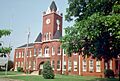
Original Coffee County Courthouse (Elba)
See also
 In Spanish: Condado de Coffee (Alabama) para niños
