Crenshaw County, Alabama facts for kids
Quick facts for kids
Crenshaw County
|
|
|---|---|

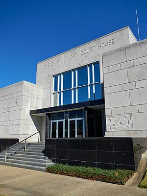
Crenshaw County courthouse in Luverne
|
|

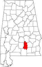
Location within the U.S. state of Alabama
|
|
 Alabama's location within the U.S. |
|
| Country | |
| State | |
| Founded | November 30, 1866 |
| Named for | Anderson Crenshaw |
| Seat | Luverne |
| Largest city | Luverne |
| Area | |
| • Total | 611 sq mi (1,580 km2) |
| • Land | 609 sq mi (1,580 km2) |
| • Water | 2.1 sq mi (5 km2) 0.3% |
| Population
(2020)
|
|
| • Total | 13,194 |
| • Estimate
(2023)
|
13,101 |
| • Density | 21.594/sq mi (8.338/km2) |
| Time zone | UTC−6 (Central) |
| • Summer (DST) | UTC−5 (CDT) |
| Congressional district | 2nd |
|
|
Crenshaw County is a county located in the south-central part of Alabama, a state in the United States. It is just south of the big city area of Montgomery. In 2020, about 13,194 people lived there. The main town and county seat is Luverne. The county is named after a famous Alabama judge, Anderson Crenshaw.
Contents
History of Crenshaw County
Crenshaw County was officially created after the American Civil War. This happened on November 30, 1866, by the state's government at that time. The county was formed using land from parts of five other counties: Butler, Coffee, Covington, Pike, and Lowndes.
Even though it was near the coast, the soil in Crenshaw County wasn't very good for growing crops like cotton. Because of this, people living there used enslaved African Americans to do all the hard farm work. Many descendants of these families still live in the area today. About one-quarter of the county's population is African American.
Crenshaw County later became important for cutting down trees, also known as timbering. This was especially true in the Piney Wood region. In 1886, a railroad line was built through the county. This railroad, called the Montgomery and Florida Railroad, made it easy to transport timber to markets. It connected to Sprague Junction in Montgomery County, Alabama.
Geography of Crenshaw County
Crenshaw County covers about 611 square miles (1,582 square kilometers). Most of this area, about 609 square miles (1,577 square kilometers), is land. Only a small part, about 2.1 square miles (5.4 square kilometers), is water.
The county is located in a flat, low-lying area of Alabama called the Gulf Coastal Plain. A lot of the land is covered by forests. These forests are used for logging, which means cutting down trees for wood.
Major Roads in Crenshaw County
These are the main highways that run through Crenshaw County:
 U.S. Highway 29
 U.S. Highway 331
 State Route 10
 State Route 97
 State Route 106
 State Route 141
 State Route 189
Neighboring Counties
Crenshaw County shares borders with these other counties:
- Montgomery County (to the north)
- Pike County (to the east)
- Coffee County (to the southeast)
- Covington County (to the south)
- Butler County (to the west)
- Lowndes County (to the northwest)
People of Crenshaw County (Demographics)
| Historical population | |||
|---|---|---|---|
| Census | Pop. | %± | |
| 1870 | 11,156 | — | |
| 1880 | 11,726 | 5.1% | |
| 1890 | 15,425 | 31.5% | |
| 1900 | 19,668 | 27.5% | |
| 1910 | 23,313 | 18.5% | |
| 1920 | 23,017 | −1.3% | |
| 1930 | 23,656 | 2.8% | |
| 1940 | 23,631 | −0.1% | |
| 1950 | 18,981 | −19.7% | |
| 1960 | 14,909 | −21.5% | |
| 1970 | 13,188 | −11.5% | |
| 1980 | 14,110 | 7.0% | |
| 1990 | 13,635 | −3.4% | |
| 2000 | 13,665 | 0.2% | |
| 2010 | 13,906 | 1.8% | |
| 2020 | 13,194 | −5.1% | |
| 2023 (est.) | 13,101 | −5.8% | |
| U.S. Decennial Census 1790–1960 1900–1990 1990–2000 2010–2020 |
|||
2020 Census Information
According to the 2020 United States census, there were 13,194 people living in Crenshaw County. These people lived in 4,943 households, and 3,384 of these were families.
Most people in the county were White (about 70.7%). About 23.4% were Black or African American. Other groups, like Native American, Asian, Pacific Islander, and people of two or more races, made up smaller parts of the population. About 1.4% of the population identified as Hispanic or Latino.
2010 Census Information
In 2010, there were 13,906 people living in the county. The population density was about 23 people for every square mile.
There were 5,652 households. About 27% of these households had children under 18 living with them. Nearly half (48.7%) were married couples. About 15.6% were households led by a woman with no husband present.
The average age of people in the county was 40.7 years old. About 23.8% of the population was under 18. About 15.9% were 65 years old or older.
The average income for a household in the county was about $35,140 per year. For families, the average income was about $47,685 per year.
Communities in Crenshaw County
Crenshaw County has one city, several towns, and many smaller unincorporated communities.
City
- Luverne (This is the county seat, meaning it's where the main county government offices are located.)
Towns
Unincorporated Communities
These are smaller places that are not officially organized as cities or towns.
- Fullers Crossroads
- Highland Home
- Honoraville
- Lapine (partly in Montgomery County)
- Moodys Crossroads
- Mulberry
- Panola
- Theba
- Weedville
See also
 In Spanish: Condado de Crenshaw para niños
 | Selma Burke |
 | Pauline Powell Burns |
 | Frederick J. Brown |
 | Robert Blackburn |

