Clayhatchee, Alabama facts for kids
Quick facts for kids
Clayhatchee, Alabama
|
|
|---|---|

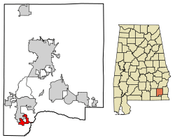
Location of Clayhatchee in Dale County, Alabama.
|
|
| Country | United States |
| State | Alabama |
| County | Dale |
| Area | |
| • Total | 2.72 sq mi (7.04 km2) |
| • Land | 2.72 sq mi (7.04 km2) |
| • Water | 0.00 sq mi (0.00 km2) |
| Elevation | 194 ft (59 m) |
| Population
(2020)
|
|
| • Total | 466 |
| • Density | 171.45/sq mi (66.20/km2) |
| Time zone | UTC-6 (Central (CST)) |
| • Summer (DST) | UTC-5 (CDT) |
| ZIP code |
36322
|
| Area code(s) | 334 |
| FIPS code | 01-15304 |
| GNIS feature ID | 0116204 |
Clayhatchee is a small town located in Dale County, Alabama, in the United States. It became an official town in April 1967. In 2020, about 466 people lived there.
Where is Clayhatchee?
Clayhatchee is found in the southwestern part of Dale County. It's nestled between Claybank Creek to the west and the Choctawhatchee River to the east.
You can get to Clayhatchee using Alabama State Route 92. This road goes east about 20 miles to Dothan and northwest about 10 miles to Enterprise. Another road, Alabama State Route 85, goes north from Clayhatchee about 5 miles to Daleville and southwest about 17 miles to Geneva.
The town covers a total area of about 2.72 square miles (7.04 square kilometers). All of this area is land, with no large bodies of water inside the town limits.
Who Lives in Clayhatchee?
The number of people living in Clayhatchee has changed over the years. Here's how the population has looked:
| Historical population | |||
|---|---|---|---|
| Census | Pop. | %± | |
| 1970 | 505 | — | |
| 1980 | 560 | 10.9% | |
| 1990 | 411 | −26.6% | |
| 2000 | 501 | 21.9% | |
| 2010 | 589 | 17.6% | |
| 2020 | 466 | −20.9% | |
| U.S. Decennial Census 2013 Estimate |
|||
In 2000, there were 501 people living in Clayhatchee. These people made up 222 households, with 152 of them being families. About 23% of the households had children under 18 living with them. Many households were married couples living together.
The people in Clayhatchee are of different ages. In 2000, about 21% of the population was under 18 years old. About 16.8% were 65 years old or older. The average age of people in the town was 42 years.
What's the Climate Like?
The weather in Clayhatchee is known for its hot and humid summers. Winters are generally mild to cool. This type of weather is called a humid subtropical climate. On climate maps, you might see it labeled as "Cfa."
Here's a quick look at the average temperatures and rainfall:
| Climate data for Clayhatchee, Alabama | |||||||||||||
|---|---|---|---|---|---|---|---|---|---|---|---|---|---|
| Month | Jan | Feb | Mar | Apr | May | Jun | Jul | Aug | Sep | Oct | Nov | Dec | Year |
| Mean daily maximum °C (°F) | 14 (57) |
16 (60) |
20 (68) |
25 (77) |
29 (84) |
31 (87) |
32 (89) |
31 (87) |
29 (84) |
25 (77) |
20 (68) |
16 (60) |
24 (75) |
| Mean daily minimum °C (°F) | 3 (37) |
5 (41) |
8 (46) |
13 (55) |
17 (62) |
20 (68) |
21 (69) |
21 (69) |
19 (66) |
13 (55) |
7 (44) |
4 (39) |
12 (53) |
| Average precipitation mm (inches) | 100 (4.1) |
140 (5.5) |
130 (5) |
120 (4.6) |
79 (3.1) |
110 (4.5) |
130 (5) |
110 (4.5) |
120 (4.8) |
86 (3.4) |
36 (1.4) |
110 (4.5) |
1,280 (50.2) |
| Source: Weatherbase | |||||||||||||
See also
 In Spanish: Clayhatchee para niños
 | Bayard Rustin |
 | Jeannette Carter |
 | Jeremiah A. Brown |

