Houston County, Alabama facts for kids
Quick facts for kids
Houston County
|
|
|---|---|
|
County
|
|

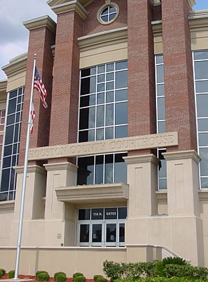
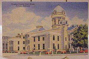
Houston County courthouse in Dothan
|
|

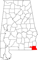
Location within the U.S. state of Alabama
|
|
 Alabama's location within the U.S. |
|
| Country | |
| State | |
| Founded | February 9, 1903 |
| Named for | George S. Houston |
| Seat | Dothan |
| Largest city | Dothan |
| Area | |
| • Total | 582 sq mi (1,510 km2) |
| • Land | 580 sq mi (1,500 km2) |
| • Water | 1.8 sq mi (5 km2) 0.3% |
| Population
(2020)
|
|
| • Total | 107,202 |
| • Estimate
(2023)
|
108,462 |
| • Density | 184.20/sq mi (71.12/km2) |
| Time zone | UTC−6 (Central) |
| • Summer (DST) | UTC−5 (CDT) |
| Congressional district | 2nd |
|
|
Houston County is a county located in the southeastern part of Alabama. In 2020, about 107,202 people lived there. The main city, called the county seat, is Dothan. Dothan is partly in Houston County and partly in Henry County.
Houston County is part of the larger Dothan, Alabama metropolitan area.
Contents
A Look Back: Houston County's History
Houston County was created on February 9, 1903. It was formed from parts of Dale, Geneva, and Henry counties. The county was named after George Smith Houston. He was the 24th Governor of Alabama.
This area of Alabama was important for its pine trees and the turpentine industry. It also had large farms that grew cotton. Many people were forced to work on these farms.
For a long time, most people living here were African American. But in the early 1900s, many moved to cities in the North and Midwest. They were looking for better jobs and to escape unfair rules. At that time, many laws made it very hard for African Americans to vote. Many poor white people also faced similar challenges.
Geography: Where is Houston County?
Houston County covers about 582 square miles. Most of this area is land, with only a small part being water. The county is located in the Wiregrass region of southeast Alabama.
Main Roads in Houston County
These are the most important highways that run through the county:
 US 84
US 84 US 231
 US 431
 SR 52
SR 52 SR 53
SR 53 SR 92
SR 92 SR 95
SR 95 SR 103
 SR 123
 SR 134
 SR 210
 SR 605
Neighboring Counties
Houston County shares its borders with these other counties:
- Henry County (to the north)
- Early County, Georgia (to the east)
- Seminole County, Georgia (to the southeast)
- Jackson County, Florida (to the south)
- Geneva County (to the west)
- Dale County (to the northwest)
Demographics: Who Lives Here?
| Historical population | |||
|---|---|---|---|
| Census | Pop. | %± | |
| 1910 | 32,414 | — | |
| 1920 | 37,334 | 15.2% | |
| 1930 | 45,935 | 23.0% | |
| 1940 | 45,665 | −0.6% | |
| 1950 | 46,522 | 1.9% | |
| 1960 | 50,718 | 9.0% | |
| 1970 | 56,574 | 11.5% | |
| 1980 | 74,632 | 31.9% | |
| 1990 | 81,331 | 9.0% | |
| 2000 | 88,787 | 9.2% | |
| 2010 | 101,547 | 14.4% | |
| 2020 | 107,202 | 5.6% | |
| 2023 (est.) | 108,462 | 6.8% | |
| U.S. Decennial Census 1790–1960 1900–1990 1990–2000 2010–2020 |
|||
In 2020, the county had 107,202 people. There were 39,761 households and 25,893 families.
Population in 2010
In 2010, there were 101,547 people living in Houston County. The population density was about 175 people per square mile.
The people living in the county were made up of different groups:
- 70.0% White
- 25.8% Black or African American
- 0.4% Native American
- 0.8% Asian
- 1.2% from other races
- 1.7% from two or more races
- 2.9% of the population were Hispanic or Latino (of any race).
About 29.2% of households had children under 18. About 47.9% were married couples living together. The average household had 2.44 people. The average family had 2.96 people.
The median age in the county was 38.5 years. This means half the people were younger than 38.5 and half were older.
Communities in Houston County
Houston County has one city, several towns, and many smaller, unincorporated communities.
City
- Dothan (This is the county seat. It is partly in Dale County and Henry County.)
Towns
Unincorporated Communities
These are smaller places that are not officially cities or towns.
See also
 In Spanish: Condado de Houston (Alabama) para niños
 | Emma Amos |
 | Edward Mitchell Bannister |
 | Larry D. Alexander |
 | Ernie Barnes |


