Madrid, Alabama facts for kids
Quick facts for kids
Madrid, Alabama
|
|
|---|---|

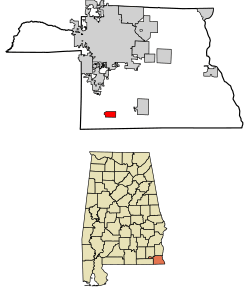
Location of Madrid in Houston County, Alabama.
|
|
| Country | United States |
| State | Alabama |
| County | Houston |
| Area | |
| • Total | 1.75 sq mi (4.52 km2) |
| • Land | 1.75 sq mi (4.52 km2) |
| • Water | 0.00 sq mi (0.00 km2) |
| Elevation | 164 ft (50 m) |
| Population
(2020)
|
|
| • Total | 265 |
| • Density | 151.69/sq mi (58.57/km2) |
| Time zone | UTC-6 (Central (CST)) |
| • Summer (DST) | UTC-5 (CDT) |
| ZIP code |
36320
|
| Area code(s) | 334 |
| FIPS code | 01-45904 |
| GNIS feature ID | 0122197 |
Madrid (pronounced MAD-rid) is a small town in Houston County, Alabama, United States. It is part of the larger Dothan area. In 2020, the town had a population of 265 people.
Contents
History of Madrid
How Madrid Began
In 1905, a railroad called the Bay Line Railroad was being built. It connected Panama City, Florida to Dothan, Alabama. Around the same time, a country road was planned to cross this new railroad.
A local resident named Ed Watford bought 180 acres of land where the road and railroad would meet. He wanted to create a town there.
Naming the Town
At the same time, two important people from Houston County, J. B. Dell and W. C. Fenn, bought 80 acres of land next to Watford's property. They quickly registered their land at the courthouse as the town of "Madrid." They named it after Madrid, Spain, but decided to pronounce it differently, with the stress on the "Mad." Because they registered first, Watford's land became known as "Watford's Addition."
Early Growth and Decline
Both Watford and Dell/Fenn divided their land into smaller lots to sell. Dell and Fenn held a big party with a barbecue and a band to attract buyers. Many people came, and both groups successfully sold most of their land.
After these sales, Madrid started to grow. It became a busy place for selling timber (wood), turpentine (a liquid from trees), and cotton. Many buildings, like stores and churches, were built. Madrid even had a mill that processed cotton.
In 1912, Mayor Ed Watford started the Bank of Madrid. This bank stayed open for 12 years before closing in 1924.
However, Madrid's population began to shrink after a while. This happened because tiny insects called boll weevils started attacking cotton crops, and the local timber supplies eventually ran out.
Geography of Madrid
Madrid is located in the southwestern part of Houston County. U.S. Route 231 runs through the western side of the town. This highway goes north about 13 miles (21 km) to Dothan and south about 18 miles (29 km) to Cottondale, Florida.
According to the U.S. Census Bureau, the town covers a total area of about 1.75 square miles (4.5 square kilometers). All of this area is land.
Population of Madrid
Population Changes Over Time
The population of Madrid has changed quite a bit over the years. Here's a look at how many people lived there during different census counts:
| Historical population | |||
|---|---|---|---|
| Census | Pop. | %± | |
| 1930 | 279 | — | |
| 1940 | 229 | −17.9% | |
| 1950 | 312 | 36.2% | |
| 1960 | 245 | −21.5% | |
| 1970 | 238 | −2.9% | |
| 1980 | 172 | −27.7% | |
| 1990 | 211 | 22.7% | |
| 2000 | 303 | 43.6% | |
| 2010 | 350 | 15.5% | |
| 2020 | 265 | −24.3% | |
| U.S. Decennial Census 2013 Estimate |
|||
2020 Census Information
The 2020 United States census counted 265 people living in Madrid. These people lived in 117 households, and 78 of those were families.
Here's a breakdown of the different groups of people living in Madrid in 2020:
| Race | Num. | Perc. |
|---|---|---|
| White (non-Hispanic) | 227 | 85.66% |
| Black or African American (non-Hispanic) | 19 | 7.17% |
| Asian | 2 | 0.75% |
| Other/Mixed | 6 | 2.26% |
| Hispanic or Latino | 11 | 4.15% |
See also
 In Spanish: Madrid (Alabama) para niños
 | Tommie Smith |
 | Simone Manuel |
 | Shani Davis |
 | Simone Biles |
 | Alice Coachman |

