
Panama City, Florida facts for kids
Quick facts for kids
Panama City, Florida
|
||
|---|---|---|
| City of Panama City | ||

Panama City's Old city hall in November 2013, prior to Hurricane Michael.
|
||
|
||

Panama City, Florida
Location in Florida

Panama City, Florida
Location in the United States
|
||
| Country | ||
| State | ||
| County | Bay | |
| Settled (Old Town-St. Andrews) | c. 1765 | |
| Settled (St. Andrews-Millville-Park Resort-Harrison-Floriopolis) | 1827 | |
| Unincorporated (Panama City) | 1906 | |
| Incorporated (City of Panama City) | 1909 | |
| Named for | Panama City, Panama | |
| Area | ||
| • City | 41.27 sq mi (106.90 km2) | |
| • Land | 35.12 sq mi (90.97 km2) | |
| • Water | 6.15 sq mi (15.93 km2) | |
| • Metro | 1,312 sq mi (3,400 km2) | |
| Elevation | 26 ft (8 m) | |
| Population
(2020)
|
||
| • City | 32,939 | |
| • Density | 937.82/sq mi (362.09/km2) | |
| • Metro | 202,236 | |
| Time zone | UTC-6 (Central (CST)) | |
| • Summer (DST) | UTC-5 (CDT) | |
| ZIP Codes |
32401–32409, 32411–32413, 32417, 32461
|
|
| Area code(s) | 850, 448 | |
| FIPS code | 12-54700 | |
| GNIS feature ID | 0288448 | |
| Website | www.pcgov.org | |

Panama City is a city in Florida, United States. It is the main city of Bay County. You can find it along U.S. Highway 98. It is the biggest city between Tallahassee and Pensacola.
Panama City is also the most populated city in the Panama City–Panama City Beach area. This larger area has about 200,534 people. In 2020, the city itself had 32,939 residents.
Contents
History of Panama City
How Panama City Got Its Name
Panama City was formed by joining several smaller communities like Floriopolis, Harrison, and St. Andrews. In 1906, this new area was named Panama City. It officially became a city in 1909.
The city's original borders were 15th Street to the north, Balboa Avenue to the west, and Bay Avenue to the east. The name "Panama City" was chosen by George Mortimer West. He wanted to attract people to the area. He noticed that a straight line from Chicago to Panama City, the capital of Panama, passed right through this Florida town. Also, Panama City was the closest developed port in the U.S. to the Caribbean entrance of the Panama Canal.
Geography and Climate
Panama City is located in the Florida Panhandle, a region known for its beautiful beaches called the Emerald Coast.
The city covers about 41.27 square miles (106.90 square kilometers). Most of this area is land, but about 6.15 square miles (15.93 square kilometers) is water.
Weather in Panama City
Panama City has a humid subtropical climate. This means it has short, mild winters and long, hot, and humid summers. In January, the average low temperature is about 42.6°F (5.9°C). In July, the average high temperature is about 91.1°F (32.8°C).
Because it is on the Gulf Coast, Panama City can be affected by tropical storms and hurricanes. For example, Hurricane Michael hit the city directly in October 2018. It was a very strong storm that caused a lot of damage. The city has also been affected by other storms and even tornadoes, like one in January 2024.
Population and People
| Historical population | |||
|---|---|---|---|
| Census | Pop. | %± | |
| 1910 | 422 | — | |
| 1920 | 1,722 | 308.1% | |
| 1930 | 5,402 | 213.7% | |
| 1940 | 11,610 | 114.9% | |
| 1950 | 25,814 | 122.3% | |
| 1960 | 33,275 | 28.9% | |
| 1970 | 32,096 | −3.5% | |
| 1980 | 33,346 | 3.9% | |
| 1990 | 34,378 | 3.1% | |
| 2000 | 36,417 | 5.9% | |
| 2010 | 36,484 | 0.2% | |
| 2020 | 32,939 | −9.7% | |
| U.S. Decennial Census | |||
In 2020, Panama City had 32,939 residents. There were about 15,733 households and 8,856 families living in the city.
In 2010, the city had 36,484 people. About 23.6% of households had children under 18. Many households were married couples, while others were single individuals or single-parent families.
The average age of people in Panama City in 2010 was about 39.7 years old. About 20.7% of the population was under 18, and 16.3% was 65 or older.
Economy and Jobs
Local Industries

The federal government is the biggest employer in Panama City, mainly because of two military bases nearby. Other important companies in the area include Eastern Shipbuilding Group, L-3 Technologies, Oceaneering, Florida Power & Light, Trane, and Jensen-Group.
Military Presence
Tyndall Air Force Base is located to the east of Panama City. After Hurricane Michael, this base is being rebuilt to become a very modern military facility. Naval Support Activity Panama City and Coast Guard Station Panama City are also close by. The Florida Army National Guard has a unit headquartered in Panama City.
Shopping Areas
Panama City has several places to shop. The Panama City Mall was a major shopping center, but it was closed after Hurricane Michael. There are plans to rebuild it into a new commercial area with shops, restaurants, and a hotel. Other popular shopping spots include Bay City Pointe, Pier Park (across the Hathaway Bridge), and various shopping strips along 15th Street and 23rd Street. Downtown Panama City and the Historic St. Andrews area also offer unique shops.
Education in Panama City
Panama City's public schools are managed by Bay District Schools. There are also several charter schools, which are public schools that operate with more freedom. These include Bay Haven and North Bay Haven.
Private schools in the city offer other choices for students. Some of these are Holy Nativity Episcopal School and St. John Catholic School.
For higher education, Panama City has several colleges and universities. Gulf Coast State College offers 4-year degrees. Florida State University has a campus here, as does Troy University. Students interested in technical skills can attend Tom P. Haney Technical College.
Local high schools in the Panama City area include Rutherford High School, Bay High School, and A. Crawford Mosley High School.
Media and News
Panama City has its own local newspaper, The News Herald. There are also several TV channels that serve the area, including WJHG (NBC), WMBB (ABC), and WPGX (Fox). Many radio stations offer different types of music and talk shows, such as WGSX (Sports Talk), WASJ (1980s/1990s/2000s hits), and WKNK (Country).
Transportation and Infrastructure
Major Roads and Highways
Two main roads run east-west through Panama City: 23rd Street and US 98. US 98 connects Panama City to Mexico Beach to the east and Panama City Beach to the west.
The main north-south roads are SR 77 (Martin Luther King Boulevard) and US 231. SR 77 leads north to Lynn Haven. US 231 heads northeast towards Dothan, Alabama.
Important Bridges
Because Panama City is located on St. Andrews Bay, bridges are very important for getting around. The three main bridges are the Bailey Bridge (north on Hwy 77), the Dupont Bridge (south on Hwy 98), and the Hathaway Bridge (west on Hwy 98). The Hathaway Bridge is the only direct link between Panama City and Panama City Beach.
Other Transportation
- Rail: The Bay Line Railroad connects Panama City north to Dothan, Alabama.
- Bus: Local bus service is provided by the Bayway, running Monday through Saturday.
- Air: The city is served by the Northwest Florida Beaches International Airport (ECP). Major airlines like Southwest, Delta, United, and American fly from here.
- Port: The Port of Panama City is an important shipping hub located on St. Andrews Bay.
Hospitals in the City
Panama City has two hospitals: Ascension Sacred Heart Bay and HCA Florida Gulf Coast Medical Center.
Notable People from Panama City
Many interesting people have connections to Panama City, including:
- Mike Campbell, a guitarist for the band Tom Petty and the Heartbreakers.
- Adam Cole, a professional wrestler.
- Clint Daniels, a country music artist.
- Dan Peek, a member of the soft rock band America.
- Blood Raw, a rapper.
- Janarius Robinson, an NFL defensive end.
- Kenny Saief, a player for the United States men's national soccer team.
Sister City
Panama City, Florida, has one sister city:
 Mérida, Yucatán, Mexico (since November 13, 2003)
Images for kids
-
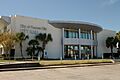
Panama City's Old city hall in November 2013, prior to Hurricane Michael.
-
Seal of Panama City, Florida.
See also
 In Spanish: Panama City (Florida) para niños
